Property Record
1900 N 200 E, Spanish Fork, UT 84660
Current Lease Availabilities
NEARBY LISTINGS FOR SALE OR LEASE
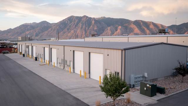
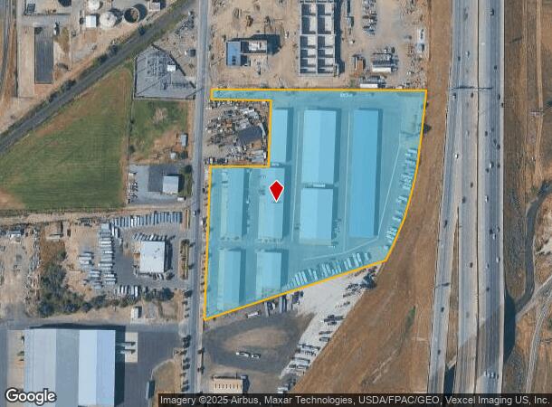
Property Detail
1900 N 200 E
Provo-Orem, UT
COM S 0 DEG 16 1 E 590.69 FT ALONG SEC. LINE & E 1364.04 FT FR W 1/4 COR. SEC. 7, T8S, R3E, SLB&M.; S 89 DEG 22 34 E 710.39 FT; ALONG A CURVE TO R (CHORD BEARS: S 6 DEG 45 54 W 256.37 FT, RADIUS = 5349.99 FT); ALONG A CURVE TO R (CHORD BEARS: S 18 DE
26-048-0113
Utah
Industrialgeneral
Utah
2024
9.01 AC
2025
Utah County
003204
Salt Lake City
89,591 SF
DEMOGRAPHICS near 1900 N 200 E
1 Mile
3 Mile
5 Mile
2024 Total Population
424
56,620
101,013
2029 Population
496
66,348
118,202
Pop Growth 2024-2029
+ 16.98%
+ 17.18%
+ 17.02%
Average Age
32
31
32
2024 Total Households
131
15,877
27,987
HH Growth 2024-2029
+ 17.56%
+ 17.48%
+ 17.33%
Median Household Inc
$71,447
$87,227
$92,133
Avg Household Size
3.20
3.50
3.60
2024 Avg HH Vehicles
2.00
2.00
3.00
Median Home Value
$330,952
$413,314
$440,500
Median Year Built
1969
2001
2000
Nearby Places
- Restaurants
- Banks
- Shops
- Fitness
- Groceries
PUBLIC TRANSPORTATION
COMMUTER RAIL
Provo Central Station (FrontRunner - Utah Transit Authority (UTA))
DRIVE
WALK
Distance
Provo Central Station (FrontRunner - Utah Transit Authority (UTA))
13 min
8.5 mi
Provo Amtrak (California Zephyr - Amtrak)
DRIVE
WALK
Distance
Provo Amtrak (California Zephyr - Amtrak)
14 min
8.5 mi
AIRPORT
Provo Municipal
DRIVE
WALK
Distance
Provo Municipal
17 min
10.5 mi
Freight Ports
Port of Stockton
DRIVE
WALK
Distance
Port of Stockton
766 min
747.1 mi
Nearby Properties
Address
Land Use
TOTAL SIZE
Lot Size
Zoning
Address
Land Use
TOTAL SIZE
Lot Size
Zoning
44,552 SF
29.78 AC
Address
Land Use
TOTAL SIZE
Lot Size
Zoning
69,236 SF
30.28 AC
Address
Land Use
TOTAL SIZE
Lot Size
Zoning
565,605 SF
20 AC
Address
Land Use
TOTAL SIZE
Lot Size
Zoning
263,859 SF
12.80 AC
Address
Land Use
TOTAL SIZE
Lot Size
Zoning
281,008 SF
16.65 AC
Address
Land Use
TOTAL SIZE
Lot Size
Zoning
281,008 SF
14.84 AC
Address
Land Use
TOTAL SIZE
Lot Size
Zoning
204,890 SF
15.28 AC
Address
Land Use
TOTAL SIZE
Lot Size
Zoning
271,536 SF
11.80 AC
Address
Land Use
TOTAL SIZE
Lot Size
Zoning
301,852 SF
20.24 AC
Address
Land Use
TOTAL SIZE
Lot Size
Zoning
170,774 SF
9.70 AC
Address
Land Use
TOTAL SIZE
Lot Size
Zoning
243,888 SF
32.23 AC
Address
Land Use
TOTAL SIZE
Lot Size
Zoning
159,679 SF
12.91 AC
Address
Land Use
TOTAL SIZE
Lot Size
Zoning
322,432 SF
29.36 AC
Address
Land Use
TOTAL SIZE
Lot Size
Zoning
210,644 SF
19.55 AC
Address
Land Use
TOTAL SIZE
Lot Size
Zoning
125,729 SF
12.84 AC
Address
Land Use
TOTAL SIZE
Lot Size
Zoning
29,819 SF
13.51 AC
Address
Land Use
TOTAL SIZE
Lot Size
Zoning
45,976 SF
39.98 AC
Address
Land Use
TOTAL SIZE
Lot Size
Zoning
184,079 SF
11.47 AC
Address
Land Use
TOTAL SIZE
Lot Size
Zoning
149,046 SF
12.10 AC
Address
Land Use
TOTAL SIZE
Lot Size
Zoning
141,566 SF
7.89 AC
Address
Land Use
TOTAL SIZE
Lot Size
Zoning
79,260 SF
5.24 AC
Address
Land Use
TOTAL SIZE
Lot Size
Zoning
134,564 SF
8.03 AC
Address
Land Use
TOTAL SIZE
Lot Size
Zoning
70.92 AC
Address
Land Use
TOTAL SIZE
Lot Size
Zoning
124,255 SF
9.87 AC
Address
Land Use
TOTAL SIZE
Lot Size
Zoning
112,094 SF
10.34 AC
Address
Land Use
TOTAL SIZE
Lot Size
Zoning
120,141 SF
7.71 AC
Address
Land Use
TOTAL SIZE
Lot Size
Zoning
41,814 SF
25.06 AC
Address
Land Use
TOTAL SIZE
Lot Size
Zoning
96,665 SF
22.25 AC
Address
Land Use
TOTAL SIZE
Lot Size
Zoning
103,642 SF
6.29 AC
Address
Land Use
TOTAL SIZE
Lot Size
Zoning
171,101 SF
11.65 AC
The World's #1 Commercial Real Estate Marketplace
Connect with us
© 2025 CoStar Group
The information above has been obtained from sources believed reliable. While we do not doubt its accuracy we have not verified it and make no guarantee, warranty or representation about it. It is your responsibility to independently confirm its accuracy and completeness. Any projections, opinions, assumptions, or estimates used are for example only and do not represent the current or future performance of the property. The value of this transaction to you depends on tax and other factors which should be evaluated by your tax, financial, and legal advisors. You and your advisors should conduct a careful, independent investigation of the property to determine to your satisfaction the suitability of the property for your needs.