Property Record
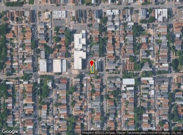
1908 W 48Th St, Chicago, IL 60609
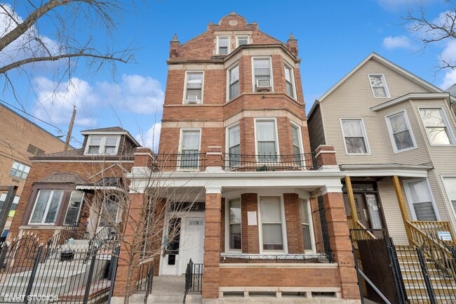

This Property Is For Sale
NEARBY LISTINGS FOR SALE OR LEASE
Property Detail
1908 W 48Th St
Chicago-Naperville-Elgin, IL-IN-WI
Stone Estate
20-07-201-026-0000
(STONE) (ESTATE) SUB OF EH OF BLK 10 OF CHICAGO UNIVE RSITY SUB OF SH OF NE & W3/4 OF SH OF NH OF NE & NW OF NW OF NE & SE OF
Apartment
Cook
X
Illinois
17031C0520J
22
2023
0.07 AC
2024
West Englewood
611400
Chicago
4,869 SF
DEMOGRAPHICS near 1908 W 48Th St
1 Mile
3 Mile
5 Mile
2024 Total Population
31,938
267,459
760,969
2029 Population
27,994
244,647
713,663
Pop Growth 2024-2029
(12.35%)
(8.53%)
(6.22%)
Average Age
35
37
37
2024 Total Households
9,456
86,623
281,911
HH Growth 2024-2029
(13.11%)
(8.83%)
(6.07%)
Median Household Inc
$35,932
$40,524
$47,808
Avg Household Size
3.20
2.90
2.50
2024 Avg HH Vehicles
1.00
1.00
1.00
Median Home Value
$173,029
$218,986
$241,396
Median Year Built
1947
1948
1952
Nearby Places
- Restaurants
- Banks
- Shops
- Fitness
- Groceries
PUBLIC TRANSPORTATION
TRANSIT/SUBWAY
Western Station (Orange Line) (Orange Line - Chicago Transit Authority "L" Trains (The "L"))
DRIVE
WALK
Distance
Western Station (Orange Line) (Orange Line - Chicago Transit Authority "L" Trains (The "L"))
2 min
19 min
1.0 mi
COMMUTER RAIL
DRIVE
WALK
Distance
9 min
4.1 mi
Western Avenue Station (BNSF) (Burlington Northern-Santa Fe Railway Line - Northeast Illinois Regional Commuter Railroad (Metra))
DRIVE
WALK
Distance
Western Avenue Station (BNSF) (Burlington Northern-Santa Fe Railway Line - Northeast Illinois Regional Commuter Railroad (Metra))
8 min
4.1 mi
AIRPORT
Chicago Midway International
DRIVE
WALK
Distance
Chicago Midway International
10 min
4.9 mi
Chicago O'Hare International
DRIVE
WALK
Distance
Chicago O'Hare International
38 min
22.7 mi
Nearby Properties
Address
Land Use
TOTAL SIZE
Lot Size
Zoning
Address
Land Use
TOTAL SIZE
Lot Size
Zoning
474,979 SF
29.67 AC
PD 553
Address
Land Use
TOTAL SIZE
Lot Size
Zoning
4.71 AC
PD 1196
Address
Land Use
TOTAL SIZE
Lot Size
Zoning
2.98 AC
PD 1196
Address
Land Use
TOTAL SIZE
Lot Size
Zoning
134,800 SF
2.53 AC
PD 1273
Address
Land Use
TOTAL SIZE
Lot Size
Zoning
0.91 AC
PD 1177
Address
Land Use
TOTAL SIZE
Lot Size
Zoning
136,720 SF
0.54 AC
PD 1
Address
Land Use
TOTAL SIZE
Lot Size
Zoning
133,354 SF
PD 1198
Address
Land Use
TOTAL SIZE
Lot Size
Zoning
169,435 SF
11.35 AC
PD 307
Address
Land Use
TOTAL SIZE
Lot Size
Zoning
307,277 SF
9.90 AC
PMD 11
Address
Land Use
TOTAL SIZE
Lot Size
Zoning
475,000 SF
14.01 AC
PMD 8
Address
Land Use
TOTAL SIZE
Lot Size
Zoning
0.84 AC
B1-3
Address
Land Use
TOTAL SIZE
Lot Size
Zoning
633,057 SF
34.96 AC
PMD 8
Address
Land Use
TOTAL SIZE
Lot Size
Zoning
72,893 SF
4.43 AC
PD 90
Address
Land Use
TOTAL SIZE
Lot Size
Zoning
1.09 AC
B2-2
Address
Land Use
TOTAL SIZE
Lot Size
Zoning
283,180 SF
1.41 AC
M2-3
Address
Land Use
TOTAL SIZE
Lot Size
Zoning
131,261 SF
7.04 AC
PD 172
Address
Land Use
TOTAL SIZE
Lot Size
Zoning
151,303 SF
0.88 AC
PD 568
Address
Land Use
TOTAL SIZE
Lot Size
Zoning
1.65 AC
B2-3
Address
Land Use
TOTAL SIZE
Lot Size
Zoning
460,333 SF
2.62 AC
C2-3
Address
Land Use
TOTAL SIZE
Lot Size
Zoning
160,487 SF
3.06 AC
PMD 11
Address
Land Use
TOTAL SIZE
Lot Size
Zoning
0.27 AC
PD 1
Address
Land Use
TOTAL SIZE
Lot Size
Zoning
9.54 AC
PD 663
Address
Land Use
TOTAL SIZE
Lot Size
Zoning
113,143 SF
PMD 8
Address
Land Use
TOTAL SIZE
Lot Size
Zoning
435,677 SF
12.37 AC
M1-2
Address
Land Use
TOTAL SIZE
Lot Size
Zoning
15.16 AC
M3-3
Address
Land Use
TOTAL SIZE
Lot Size
Zoning
85,990 SF
6.46 AC
PD 411
Address
Land Use
TOTAL SIZE
Lot Size
Zoning
352,529 SF
12.77 AC
PMD 8
Address
Land Use
TOTAL SIZE
Lot Size
Zoning
273,975 SF
7.22 AC
M1-1
Address
Land Use
TOTAL SIZE
Lot Size
Zoning
Address
Land Use
TOTAL SIZE
Lot Size
Zoning
283,228 SF
14.47 AC
PMD 8
The World's #1 Commercial Real Estate Marketplace
Connect with us
© 2025 CoStar Group
The information above has been obtained from sources believed reliable. While we do not doubt its accuracy we have not verified it and make no guarantee, warranty or representation about it. It is your responsibility to independently confirm its accuracy and completeness. Any projections, opinions, assumptions, or estimates used are for example only and do not represent the current or future performance of the property. The value of this transaction to you depends on tax and other factors which should be evaluated by your tax, financial, and legal advisors. You and your advisors should conduct a careful, independent investigation of the property to determine to your satisfaction the suitability of the property for your needs.