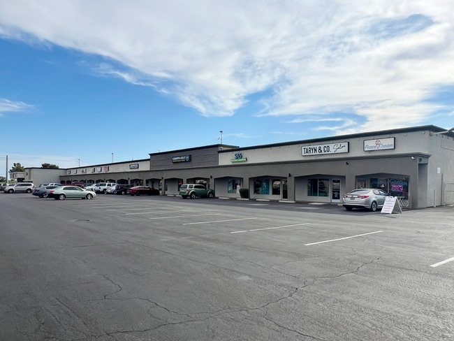
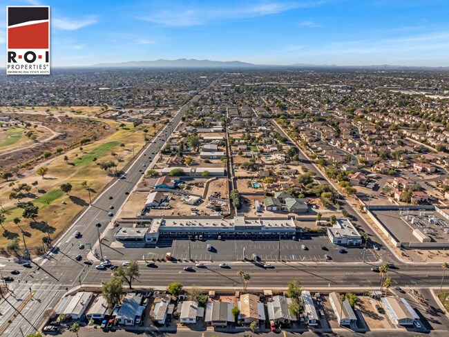
Property Record
1908 W Greenway Rd, Phoenix, AZ 85023
Current Lease Availabilities
NEARBY LISTINGS FOR SALE OR LEASE
Property Detail
1908 W Greenway Rd
Phoenix-Mesa-Chandler, AZ
Sierra Prieta Estates
208-14-011
CHINO BANDITO MCR 242-07
Storebuilding
Maricopa
X
Arizona
04013C1290M
1
2025
0.93 AC
2025
N Phoenix/I-17 Corr
103608
Phoenix
24,042 SF
DEMOGRAPHICS near 1908 W Greenway Rd
1 mile
3 mile
5 mile
2024 Total Population
15,195
148,306
380,815
2029 Population
16,718
160,111
411,018
Pop Growth 2024-2029
+ 10.02%
+ 7.96%
+ 7.93%
Average Age
36
38
38
2024 Total Households
6,267
59,512
150,111
HH Growth 2024-2029
+ 10.45%
+ 8.18%
+ 8.12%
Median Household Inc
$51,528
$61,236
$62,186
Avg Household Size
2.40
2.40
2.40
2024 Avg HH Vehicles
2.00
2.00
2.00
Median Home Value
$345,014
$312,937
$309,864
Median Year Built
1989
1981
1982
Nearby Places
Map Layers
Map Styles
 Street
 Aerial
Transit
 Traffic
 Biking
Places
Listings with unknown addresses are not visible on the map
- Restaurants
- Banks
- Shops
- Fitness
- Groceries
PUBLIC TRANSPORTATION
AIRPORT
Phoenix Sky Harbor International
Drive
Walk
Distance
Phoenix Sky Harbor International
25 min
20.3 mi
Freight Ports
Port of San Diego
Drive
Walk
Distance
Port of San Diego
1 min
299.4 mi
Nearby Properties
Address
Land Use
TOTAL SIZE
Lot Size
Zoning
Address
Land Use
TOTAL SIZE
Lot Size
Zoning
249,119 SF
15.40 AC
PUD
Address
Land Use
TOTAL SIZE
Lot Size
Zoning
10.70 AC
I-P
Address
Land Use
TOTAL SIZE
Lot Size
Zoning
98,760 SF
6.76 AC
A-1
Address
Land Use
TOTAL SIZE
Lot Size
Zoning
4.71 AC
Address
Land Use
TOTAL SIZE
Lot Size
Zoning
526,912 SF
55.64 AC
Address
Land Use
TOTAL SIZE
Lot Size
Zoning
704,521 SF
15.12 AC
C-C
Address
Land Use
TOTAL SIZE
Lot Size
Zoning
625,318 SF
15.79 AC
Address
Land Use
TOTAL SIZE
Lot Size
Zoning
1,089,213 SF
53.03 AC
R-3
Address
Land Use
TOTAL SIZE
Lot Size
Zoning
17,365 SF
1.50 AC
C-G
Address
Land Use
TOTAL SIZE
Lot Size
Zoning
2.62 AC
IND.PK.
Address
Land Use
TOTAL SIZE
Lot Size
Zoning
16,284 SF
3.77 AC
M-H
Address
Land Use
TOTAL SIZE
Lot Size
Zoning
314,839 SF
39 AC
R-18
Address
Land Use
TOTAL SIZE
Lot Size
Zoning
290,321 SF
37.97 AC
R-8
Address
Land Use
TOTAL SIZE
Lot Size
Zoning
336,529 SF
11.23 AC
R4A
Address
Land Use
TOTAL SIZE
Lot Size
Zoning
469,322 SF
22.40 AC
M-H
Address
Land Use
TOTAL SIZE
Lot Size
Zoning
229,000 SF
18.99 AC
I-P
Address
Land Use
TOTAL SIZE
Lot Size
Zoning
268,353 SF
20.45 AC
I-P
Address
Land Use
TOTAL SIZE
Lot Size
Zoning
430,038 SF
26.71 AC
M-H
Address
Land Use
TOTAL SIZE
Lot Size
Zoning
362,729 SF
21.85 AC
Address
Land Use
TOTAL SIZE
Lot Size
Zoning
145,956 SF
10.30 AC
CP/GCP
Address
Land Use
TOTAL SIZE
Lot Size
Zoning
358,670 SF
18.14 AC
M-H
Address
Land Use
TOTAL SIZE
Lot Size
Zoning
358,005 SF
8.54 AC
M-H
Address
Land Use
TOTAL SIZE
Lot Size
Zoning
120,494 SF
11.17 AC
C-C
Address
Land Use
TOTAL SIZE
Lot Size
Zoning
221,641 SF
21.60 AC
C-2
Address
Land Use
TOTAL SIZE
Lot Size
Zoning
171,751 SF
8.61 AC
C-2
Address
Land Use
TOTAL SIZE
Lot Size
Zoning
2.99 AC
C-R
Address
Land Use
TOTAL SIZE
Lot Size
Zoning
267,747 SF
8.91 AC
M-H
Address
Land Use
TOTAL SIZE
Lot Size
Zoning
229,447 SF
23.43 AC
Address
Land Use
TOTAL SIZE
Lot Size
Zoning
277,659 SF
23.52 AC
Address
Land Use
TOTAL SIZE
Lot Size
Zoning
390,668 SF
18.67 AC
M-H
The World's #1 Commercial Real Estate Marketplace
Connect with us
© 2026 CoStar Group
The information above has been obtained from sources believed reliable. While we do not doubt its accuracy we have not verified it and make no guarantee, warranty or representation about it. It is your responsibility to independently confirm its accuracy and completeness. Any projections, opinions, assumptions, or estimates used are for example only and do not represent the current or future performance of the property. The value of this transaction to you depends on tax and other factors which should be evaluated by your tax, financial, and legal advisors. You and your advisors should conduct a careful, independent investigation of the property to determine to your satisfaction the suitability of the property for your needs.