Property Record
1909 Nw Unknown Hwy, Melbourne, FL 32904
NEARBY LISTINGS FOR SALE OR LEASE
-
-
-
-
-
-
-
No Photo
-
View all Melbourne listings for sale on LoopNet.com
Property Detail
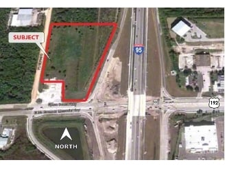
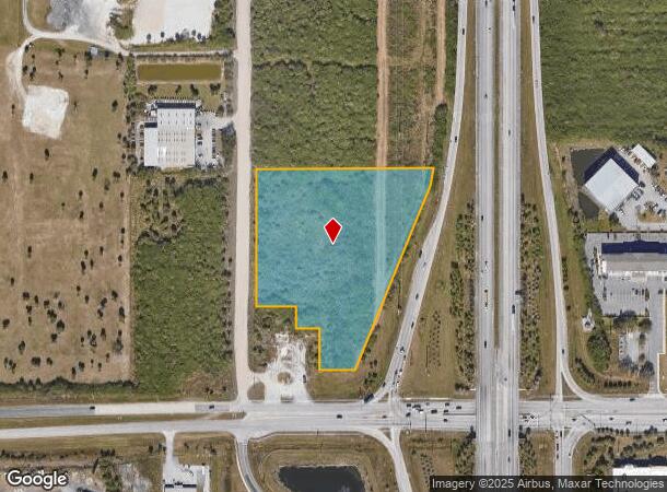
1909 Nw Unknown Hwy
Palm Bay-Melbourne-Titusville, FL
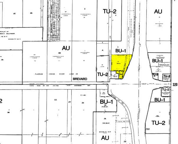
Florida Indian River Land Co
28-36-03-00-00008.1-0000.00
PART OF S 1/2 OF NE 1/4 AS DESC IN ORB 902 PG 927 & 960 PG 509 PAR 11
Commercialacreage
Brevard
AE
Florida
12009C0579G
5.62 AC
2024
Brevard County
2025
Orlando
0713012037
DEMOGRAPHICS near 1909 Nw Unknown Hwy
1 Mile
3 Mile
5 Mile
2024 Total Population
3,799
21,884
89,490
2029 Population
4,204
24,050
97,846
Pop Growth 2024-2029
+ 10.66%
+ 9.90%
+ 9.34%
Average Age
44
43
43
2024 Total Households
1,521
8,547
35,573
HH Growth 2024-2029
+ 10.45%
+ 9.58%
+ 9.19%
Median Household Inc
$74,648
$77,936
$67,929
Avg Household Size
2.40
2.50
2.40
2024 Avg HH Vehicles
2.00
2.00
2.00
Median Home Value
$287,182
$295,429
$244,137
Median Year Built
1990
1989
1987
Nearby Places
Map Layers
Map Styles
 Street
 Aerial
- Restaurants
- Banks
- Shops
- Fitness
- Groceries
PUBLIC TRANSPORTATION
AIRPORT
Melbourne Orlando International
DRIVE
WALK
Distance
Melbourne Orlando International
14 min
6.1 mi
Freight Ports
Port Canaveral
DRIVE
WALK
Distance
Port Canaveral
43 min
34.6 mi
Nearby Properties
Address
Land Use
TOTAL SIZE
Lot Size
Zoning
Address
Land Use
TOTAL SIZE
Lot Size
Zoning
433,669 SF
21.22 AC
AU
Address
Land Use
TOTAL SIZE
Lot Size
Zoning
506,643 SF
80 AC
RA
Address
Land Use
TOTAL SIZE
Lot Size
Zoning
425,167 SF
43.33 AC
Address
Land Use
TOTAL SIZE
Lot Size
Zoning
265,272 SF
21.17 AC
M1
Address
Land Use
TOTAL SIZE
Lot Size
Zoning
384,430 SF
33.07 AC
R2
Address
Land Use
TOTAL SIZE
Lot Size
Zoning
389,175 SF
12.18 AC
Address
Land Use
TOTAL SIZE
Lot Size
Zoning
261,552 SF
23.21 AC
R2
Address
Land Use
TOTAL SIZE
Lot Size
Zoning
268,487 SF
20.08 AC
RA
Address
Land Use
TOTAL SIZE
Lot Size
Zoning
196,130 SF
16 AC
Address
Land Use
TOTAL SIZE
Lot Size
Zoning
95,944 SF
17.22 AC
GU
Address
Land Use
TOTAL SIZE
Lot Size
Zoning
58,607 SF
2.79 AC
Address
Land Use
TOTAL SIZE
Lot Size
Zoning
163,449 SF
11.20 AC
M1
Address
Land Use
TOTAL SIZE
Lot Size
Zoning
130,907 SF
20 AC
M1
Address
Land Use
TOTAL SIZE
Lot Size
Zoning
193,940 SF
38.87 AC
Address
Land Use
TOTAL SIZE
Lot Size
Zoning
119,111 SF
6.88 AC
M1
Address
Land Use
TOTAL SIZE
Lot Size
Zoning
68,775 SF
7.57 AC
Address
Land Use
TOTAL SIZE
Lot Size
Zoning
52,145 SF
7.59 AC
Address
Land Use
TOTAL SIZE
Lot Size
Zoning
84,039 SF
10.30 AC
CP
Address
Land Use
TOTAL SIZE
Lot Size
Zoning
226,960 SF
21.49 AC
M1
Address
Land Use
TOTAL SIZE
Lot Size
Zoning
151,324 SF
16.12 AC
BU2
Address
Land Use
TOTAL SIZE
Lot Size
Zoning
140,826 SF
15.93 AC
M1
Address
Land Use
TOTAL SIZE
Lot Size
Zoning
68,558 SF
7.17 AC
M2
Address
Land Use
TOTAL SIZE
Lot Size
Zoning
119,767 SF
7.10 AC
M1
Address
Land Use
TOTAL SIZE
Lot Size
Zoning
49,296 SF
2.94 AC
BU-1
Address
Land Use
TOTAL SIZE
Lot Size
Zoning
55,076 SF
2.36 AC
Address
Land Use
TOTAL SIZE
Lot Size
Zoning
124,692 SF
10.47 AC
C
Address
Land Use
TOTAL SIZE
Lot Size
Zoning
96,854 SF
7.51 AC
CP
Address
Land Use
TOTAL SIZE
Lot Size
Zoning
33,726 SF
12.81 AC
BU1
Address
Land Use
TOTAL SIZE
Lot Size
Zoning
123,080 SF
10.02 AC
M1
Address
Land Use
TOTAL SIZE
Lot Size
Zoning
95,029 SF
8.53 AC
TU-2
The World's #1 Commercial Real Estate Marketplace
Connect with us
© 2026 CoStar Group
The information above has been obtained from sources believed reliable. While we do not doubt its accuracy we have not verified it and make no guarantee, warranty or representation about it. It is your responsibility to independently confirm its accuracy and completeness. Any projections, opinions, assumptions, or estimates used are for example only and do not represent the current or future performance of the property. The value of this transaction to you depends on tax and other factors which should be evaluated by your tax, financial, and legal advisors. You and your advisors should conduct a careful, independent investigation of the property to determine to your satisfaction the suitability of the property for your needs.