Property Record
1909 Old Mansfield Rd, Wooster, OH 44691


NEARBY LISTINGS FOR SALE OR LEASE
Property Detail
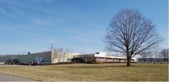
1909 Old Mansfield Rd
68-00117-000
13-15-05 NMPT SW 17.58A MP 56 CD 190
Warehouse
Wayne
AE
Ohio
39169C0211E
17.58 AC
2024
Ohio North Area
2024
Other Market Areas
000600
Wooster, OH
89,980 SF
DEMOGRAPHICS near 1909 Old Mansfield Rd
1 Mile
3 Mile
5 Mile
2024 Total Population
1,494
26,564
38,596
2029 Population
1,516
26,808
38,912
Pop Growth 2024-2029
+ 1.47%
+ 0.92%
+ 0.82%
Average Age
42
40
41
2024 Total Households
633
10,583
15,594
HH Growth 2024-2029
+ 1.26%
+ 0.87%
+ 0.75%
Median Household Inc
$54,453
$54,580
$57,062
Avg Household Size
2.20
2.20
2.20
2024 Avg HH Vehicles
2.00
2.00
2.00
Median Home Value
$183,128
$177,694
$183,892
Median Year Built
1988
1969
1975
Nearby Places
Map Layers
Map Styles
 Street
 Aerial
- Restaurants
- Banks
- Shops
- Fitness
- Groceries
PUBLIC TRANSPORTATION
AIRPORT
Akron-Canton Regional
DRIVE
WALK
Distance
Akron-Canton Regional
57 min
44.4 mi
Freight Ports
Port of Toledo
DRIVE
WALK
Distance
Port of Toledo
160 min
117.2 mi
SALE & LEASE HISTORY
LISTING DATE
SALE/LEASE

Sep 26, 2016
For Lease
Nov 08, 2016
For Sale
Mar 18, 2025
For Lease
Jun 25, 2024
For Lease
Nearby Properties
Address
Land Use
TOTAL SIZE
Lot Size
Zoning
Address
Land Use
TOTAL SIZE
Lot Size
Zoning
537,309 SF
43.72 AC
CF
Address
Land Use
TOTAL SIZE
Lot Size
Zoning
70,726 SF
9 AC
CF
Address
Land Use
TOTAL SIZE
Lot Size
Zoning
2,268 SF
106.60 AC
CF
Address
Land Use
TOTAL SIZE
Lot Size
Zoning
152,523 SF
74.14 AC
CF
Address
Land Use
TOTAL SIZE
Lot Size
Zoning
81,133 SF
41.43 AC
CF
Address
Land Use
TOTAL SIZE
Lot Size
Zoning
7.28 AC
CF
Address
Land Use
TOTAL SIZE
Lot Size
Zoning
48,096 SF
1.67 AC
C4
Address
Land Use
TOTAL SIZE
Lot Size
Zoning
50,110 SF
19.26 AC
CF
Address
Land Use
TOTAL SIZE
Lot Size
Zoning
25.14 AC
CF
Address
Land Use
TOTAL SIZE
Lot Size
Zoning
47,160 SF
3.22 AC
C4
Address
Land Use
TOTAL SIZE
Lot Size
Zoning
4,486 SF
5.57 AC
CF
Address
Land Use
TOTAL SIZE
Lot Size
Zoning
210,000 SF
20 AC
Address
Land Use
TOTAL SIZE
Lot Size
Zoning
2,536 SF
16.79 AC
R4
Address
Land Use
TOTAL SIZE
Lot Size
Zoning
62,976 SF
10.46 AC
CF
Address
Land Use
TOTAL SIZE
Lot Size
Zoning
58,600 SF
6.30 AC
CF
Address
Land Use
TOTAL SIZE
Lot Size
Zoning
81,724 SF
19.59 AC
CF
Address
Land Use
TOTAL SIZE
Lot Size
Zoning
10.68 AC
M3
Address
Land Use
TOTAL SIZE
Lot Size
Zoning
71,511 SF
9.53 AC
CF
Address
Land Use
TOTAL SIZE
Lot Size
Zoning
5,156 SF
2.68 AC
R1
Address
Land Use
TOTAL SIZE
Lot Size
Zoning
6,631 SF
7.18 AC
R4
Address
Land Use
TOTAL SIZE
Lot Size
Zoning
61,107 SF
2.77 AC
C5
Address
Land Use
TOTAL SIZE
Lot Size
Zoning
25,920 SF
42 AC
CF
Address
Land Use
TOTAL SIZE
Lot Size
Zoning
2,380 SF
10.01 AC
CF
Address
Land Use
TOTAL SIZE
Lot Size
Zoning
72,917 SF
6.96 AC
CF
Address
Land Use
TOTAL SIZE
Lot Size
Zoning
62,707 SF
21.93 AC
M2
Address
Land Use
TOTAL SIZE
Lot Size
Zoning
54,501 SF
3.96 AC
C5
Address
Land Use
TOTAL SIZE
Lot Size
Zoning
17.43 AC
M2
Address
Land Use
TOTAL SIZE
Lot Size
Zoning
29,316 SF
17.82 AC
CF
Address
Land Use
TOTAL SIZE
Lot Size
Zoning
32,797 SF
4.60 AC
C1
The World's #1 Commercial Real Estate Marketplace
Connect with us
© 2025 CoStar Group
The information above has been obtained from sources believed reliable. While we do not doubt its accuracy we have not verified it and make no guarantee, warranty or representation about it. It is your responsibility to independently confirm its accuracy and completeness. Any projections, opinions, assumptions, or estimates used are for example only and do not represent the current or future performance of the property. The value of this transaction to you depends on tax and other factors which should be evaluated by your tax, financial, and legal advisors. You and your advisors should conduct a careful, independent investigation of the property to determine to your satisfaction the suitability of the property for your needs.