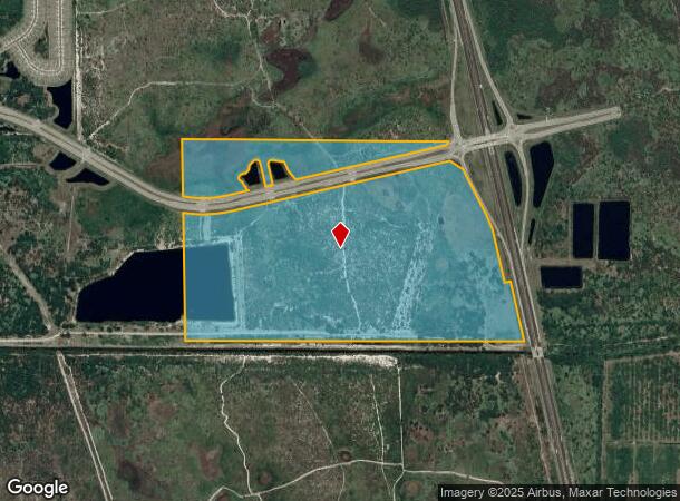
Property Record
1909 Unknown, , FL

NEARBY LISTINGS FOR SALE OR LEASE
Property Detail
1909 Unknown
Palm Bay-Melbourne-Titusville, FL
Acreage
30-37-11-00-00001.0-0000.00
N 1/2 W OF I-95 R/W EXC ORB 7532 PG 2932, 7533 PG 171 & ORB 8221 PG 641
Agriculturalland
Brevard
A
Florida
12009C0690G
204.55 AC
2024
Brevard County
2025
Orlando
065236
DEMOGRAPHICS near 1909 Unknown
1 Mile
3 Mile
5 Mile
2024 Total Population
117
5,580
29,618
2029 Population
132
6,202
32,396
Pop Growth 2024-2029
+ 12.82%
+ 11.15%
+ 9.38%
Average Age
53
44
47
2024 Total Households
50
2,066
12,005
HH Growth 2024-2029
+ 12.00%
+ 10.94%
+ 9.05%
Median Household Inc
$119,999
$103,552
$84,586
Avg Household Size
2.30
2.60
2.40
2024 Avg HH Vehicles
2.00
2.00
2.00
Median Home Value
$531,250
$419,053
$335,117
Median Year Built
2000
2005
2000
Nearby Places
Map Layers
Map Styles
 Street
 Aerial
- Restaurants
- Banks
- Shops
- Fitness
- Groceries
PUBLIC TRANSPORTATION
AIRPORT
Melbourne Orlando International
DRIVE
WALK
Distance
Melbourne Orlando International
27 min
16.6 mi
Freight Ports
Port Canaveral
DRIVE
WALK
Distance
Port Canaveral
59 min
49.7 mi
SALE & LEASE HISTORY
LISTING DATE
SALE/LEASE

Sep 16, 2025
For Lease
Nearby Properties
Address
Land Use
TOTAL SIZE
Lot Size
Zoning
Address
Land Use
TOTAL SIZE
Lot Size
Zoning
111,898 SF
25.04 AC
AU
Address
Land Use
TOTAL SIZE
Lot Size
Zoning
66,453 SF
13.89 AC
Address
Land Use
TOTAL SIZE
Lot Size
Zoning
294.44 AC
GU
Address
Land Use
TOTAL SIZE
Lot Size
Zoning
320 AC
RR1
Address
Land Use
TOTAL SIZE
Lot Size
Zoning
230.52 AC
GU
Address
Land Use
TOTAL SIZE
Lot Size
Zoning
300 AC
GU
Address
Land Use
TOTAL SIZE
Lot Size
Zoning
636 AC
GML-P
Address
Land Use
TOTAL SIZE
Lot Size
Zoning
16,147 SF
17.31 AC
AU
Address
Land Use
TOTAL SIZE
Lot Size
Zoning
123 AC
RR-1
Address
Land Use
TOTAL SIZE
Lot Size
Zoning
2.10 AC
Address
Land Use
TOTAL SIZE
Lot Size
Zoning
186.78 AC
AU
Address
Land Use
TOTAL SIZE
Lot Size
Zoning
15.25 AC
CC
Address
Land Use
TOTAL SIZE
Lot Size
Zoning
558.10 AC
GML-P
Address
Land Use
TOTAL SIZE
Lot Size
Zoning
142 AC
RR-1
Address
Land Use
TOTAL SIZE
Lot Size
Zoning
240 SF
12.27 AC
CC
Address
Land Use
TOTAL SIZE
Lot Size
Zoning
209.80 AC
GU
Address
Land Use
TOTAL SIZE
Lot Size
Zoning
397.60 AC
GML-P
Address
Land Use
TOTAL SIZE
Lot Size
Zoning
Address
Land Use
TOTAL SIZE
Lot Size
Zoning
39.34 AC
AGR
Address
Land Use
TOTAL SIZE
Lot Size
Zoning
1.12 AC
Address
Land Use
TOTAL SIZE
Lot Size
Zoning
5,560 SF
1.29 AC
IN(L)
Address
Land Use
TOTAL SIZE
Lot Size
Zoning
20.59 AC
Address
Land Use
TOTAL SIZE
Lot Size
Zoning
240 SF
32.41 AC
IU
Address
Land Use
TOTAL SIZE
Lot Size
Zoning
313.89 AC
Address
Land Use
TOTAL SIZE
Lot Size
Zoning
4,516 SF
4.08 AC
IN(L)
Address
Land Use
TOTAL SIZE
Lot Size
Zoning
5,102 SF
0.80 AC
RS2
Address
Land Use
TOTAL SIZE
Lot Size
Zoning
2,223 SF
14.86 AC
GU
Address
Land Use
TOTAL SIZE
Lot Size
Zoning
3,502 SF
13.50 AC
AU
Address
Land Use
TOTAL SIZE
Lot Size
Zoning
230.30 AC
GML-P
Address
Land Use
TOTAL SIZE
Lot Size
Zoning
530 SF
14.12 AC
RR
The World's #1 Commercial Real Estate Marketplace
Connect with us
© 2026 CoStar Group
The information above has been obtained from sources believed reliable. While we do not doubt its accuracy we have not verified it and make no guarantee, warranty or representation about it. It is your responsibility to independently confirm its accuracy and completeness. Any projections, opinions, assumptions, or estimates used are for example only and do not represent the current or future performance of the property. The value of this transaction to you depends on tax and other factors which should be evaluated by your tax, financial, and legal advisors. You and your advisors should conduct a careful, independent investigation of the property to determine to your satisfaction the suitability of the property for your needs.