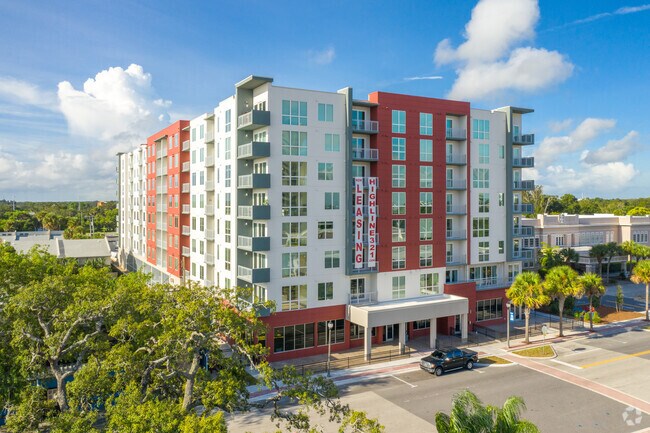
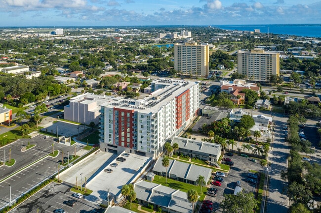
Property Record
1909 Unknown, Melbourne, FL 32901
Current Lease Availabilities
Property Detail
1909 Unknown
Palm Bay-Melbourne-Titusville, FL
FEES UNREC SUBD PART OF LOTS 5, 6 & 7 AS DESC IN IN ORB 3079 PG 4894 EXC ORB 7598 PG 604
28-37-03-75-00000.0-0006.04
BREVARD
Apartment
Florida
B and X Area of moderate flood hazard, usually the area between the limits of the 100-year and 500-year floods.
5
2024
1.27 AC
2025
Downtown Melbourne
064902
Orlando
213,482 SF
NEARBY LISTINGS FOR SALE OR LEASE
DEMOGRAPHICS near 1909 Unknown
1 mile
3 mile
5 mile
2025 Total Population
7,432
55,369
141,493
2030 Population
7,995
60,021
152,377
Pop Growth 2025-2030
+ 7.58%
+ 8.40%
+ 7.69%
Average Age
45
44
44
2025 Total Households
3,430
24,532
61,418
HH Growth 2025-2030
+ 7.41%
+ 8.18%
+ 7.48%
Median Household Inc
$35,275
$63,454
$72,743
Avg Household Size
1.90
2.10
2.20
2025 Avg HH Vehicles
1.00
2.00
2.00
Median Home Value
$312,131
$321,075
$333,848
Median Year Built
1975
1983
1984
Nearby Places
Map Layers
Map Styles
 Street
 Aerial
Transit
 Traffic
 Biking
Places
Listings with unknown addresses are not visible on the map
- Restaurants
- Banks
- Shops
- Fitness
- Groceries
PUBLIC TRANSPORTATION
AIRPORT
Melbourne Orlando International
Drive
Walk
Distance
Melbourne Orlando International
7 min
2.3 mi
Nearby Properties
Address
Land Use
TOTAL SIZE
Lot Size
Zoning
Address
Land Use
TOTAL SIZE
Lot Size
Zoning
1,105,462 SF
18.74 AC
CC1
Address
Land Use
TOTAL SIZE
Lot Size
Zoning
1,245,196 SF
110.73 AC
I1
Address
Land Use
TOTAL SIZE
Lot Size
Zoning
408,025 SF
15.72 AC
Address
Land Use
TOTAL SIZE
Lot Size
Zoning
475,791 SF
229.02 AC
M1
Address
Land Use
TOTAL SIZE
Lot Size
Zoning
332,802 SF
37.02 AC
I1
Address
Land Use
TOTAL SIZE
Lot Size
Zoning
368,326 SF
14.77 AC
C1
Address
Land Use
TOTAL SIZE
Lot Size
Zoning
387,843 SF
27.19 AC
R3
Address
Land Use
TOTAL SIZE
Lot Size
Zoning
342,276 SF
12.53 AC
LI
Address
Land Use
TOTAL SIZE
Lot Size
Zoning
197,734 SF
27.99 AC
M1
Address
Land Use
TOTAL SIZE
Lot Size
Zoning
393,147 SF
38.03 AC
RM20
Address
Land Use
TOTAL SIZE
Lot Size
Zoning
280,518 SF
13.88 AC
Address
Land Use
TOTAL SIZE
Lot Size
Zoning
24.95 AC
I1
Address
Land Use
TOTAL SIZE
Lot Size
Zoning
295,347 SF
14.61 AC
R2
Address
Land Use
TOTAL SIZE
Lot Size
Zoning
213,704 SF
0.57 AC
CC3
Address
Land Use
TOTAL SIZE
Lot Size
Zoning
542,262 SF
51.88 AC
CP
Address
Land Use
TOTAL SIZE
Lot Size
Zoning
201,017 SF
13.77 AC
RM20
Address
Land Use
TOTAL SIZE
Lot Size
Zoning
330,705 SF
25 AC
I1
Address
Land Use
TOTAL SIZE
Lot Size
Zoning
309,725 SF
14.70 AC
R2 (6)
Address
Land Use
TOTAL SIZE
Lot Size
Zoning
184,447 SF
14.06 AC
R2
Address
Land Use
TOTAL SIZE
Lot Size
Zoning
219,628 SF
29.84 AC
R2(6)
Address
Land Use
TOTAL SIZE
Lot Size
Zoning
201,325 SF
11.41 AC
Address
Land Use
TOTAL SIZE
Lot Size
Zoning
226,121 SF
17.73 AC
Address
Land Use
TOTAL SIZE
Lot Size
Zoning
560,257 SF
118.47 AC
LI
Address
Land Use
TOTAL SIZE
Lot Size
Zoning
225,020 SF
24.25 AC
Address
Land Use
TOTAL SIZE
Lot Size
Zoning
364,027 SF
22.91 AC
C2
Address
Land Use
TOTAL SIZE
Lot Size
Zoning
182,494 SF
8.53 AC
CCP
Address
Land Use
TOTAL SIZE
Lot Size
Zoning
219,361 SF
3.63 AC
CC3
Address
Land Use
TOTAL SIZE
Lot Size
Zoning
139,968 SF
23.46 AC
CRA
Address
Land Use
TOTAL SIZE
Lot Size
Zoning
205,564 SF
14.56 AC
M1
The World's #1 Commercial Real Estate Marketplace
Connect with us
© 2026 CoStar Group
The information above has been obtained from sources believed reliable. While we do not doubt its accuracy we have not verified it and make no guarantee, warranty or representation about it. It is your responsibility to independently confirm its accuracy and completeness. Any projections, opinions, assumptions, or estimates used are for example only and do not represent the current or future performance of the property. The value of this transaction to you depends on tax and other factors which should be evaluated by your tax, financial, and legal advisors. You and your advisors should conduct a careful, independent investigation of the property to determine to your satisfaction the suitability of the property for your needs.