Property Record
1909 Unknown, Melbourne, FL 32904
NEARBY LISTINGS FOR SALE OR LEASE
-
-
-
-
-
-
Minton Rd & Heritage Oaks blvd
West Melbourne, FL 32904
$600,000 - $3,500,000
0.53 - 2.28 AC Lot
Land
-
-
-
-
-
-
-
-
View all Melbourne listings for sale on LoopNet.com
Property Detail
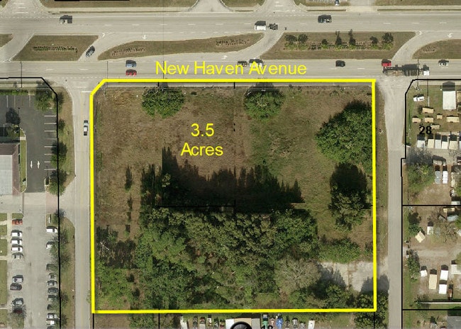
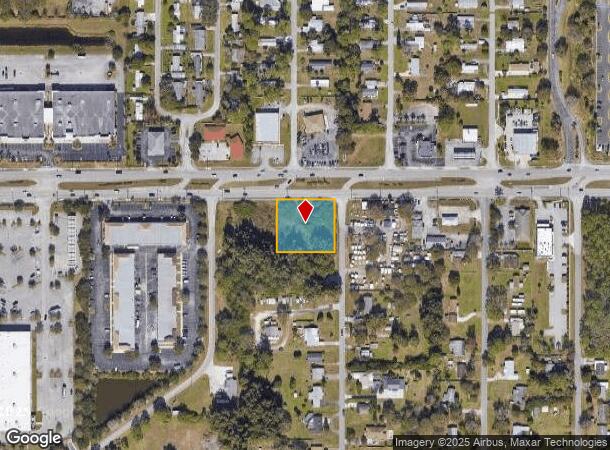
1909 Unknown
Palm Bay-Melbourne-Titusville, FL
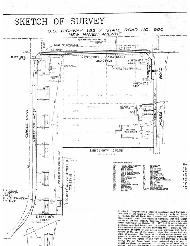
City Acres
28-36-02-75-00014.0-0024.00
CITY ACRES E 40 FT OF LOT 24 & ALL LOTS 25, 26 & 27 BLK 14 EXC HWY R/W
Commercialacreage
Brevard
X
Florida
12009C0579G
24
2024
0.81 AC
2025
Brevard County
0650011008
Orlando
DEMOGRAPHICS near 1909 Unknown
1 Mile
3 Mile
5 Mile
2024 Total Population
6,406
32,713
116,799
2029 Population
7,058
35,808
127,778
Pop Growth 2024-2029
+ 10.18%
+ 9.46%
+ 9.40%
Average Age
44
43
43
2024 Total Households
2,545
12,990
47,720
HH Growth 2024-2029
+ 9.94%
+ 9.21%
+ 9.27%
Median Household Inc
$76,987
$77,205
$62,644
Avg Household Size
2.40
2.40
2.30
2024 Avg HH Vehicles
2.00
2.00
2.00
Median Home Value
$294,160
$278,207
$237,308
Median Year Built
1988
1992
1987
Nearby Places
Map Layers
Map Styles
 Street
 Aerial
- Restaurants
- Banks
- Shops
- Fitness
- Groceries
PUBLIC TRANSPORTATION
AIRPORT
Melbourne Orlando International
DRIVE
WALK
Distance
Melbourne Orlando International
12 min
5.1 mi
Freight Ports
Port Canaveral
DRIVE
WALK
Distance
Port Canaveral
44 min
35.4 mi
SALE & LEASE HISTORY
LISTING DATE
SALE/LEASE

Sep 24, 2016
For Sale
Nearby Properties
Address
Land Use
TOTAL SIZE
Lot Size
Zoning
Address
Land Use
TOTAL SIZE
Lot Size
Zoning
433,669 SF
21.22 AC
AU
Address
Land Use
TOTAL SIZE
Lot Size
Zoning
506,643 SF
80 AC
RA
Address
Land Use
TOTAL SIZE
Lot Size
Zoning
380,944 SF
32.18 AC
RA
Address
Land Use
TOTAL SIZE
Lot Size
Zoning
425,167 SF
43.33 AC
Address
Land Use
TOTAL SIZE
Lot Size
Zoning
265,272 SF
21.17 AC
M1
Address
Land Use
TOTAL SIZE
Lot Size
Zoning
384,430 SF
33.07 AC
R2
Address
Land Use
TOTAL SIZE
Lot Size
Zoning
389,175 SF
12.18 AC
Address
Land Use
TOTAL SIZE
Lot Size
Zoning
387,843 SF
27.19 AC
R3
Address
Land Use
TOTAL SIZE
Lot Size
Zoning
197,734 SF
27.99 AC
M1
Address
Land Use
TOTAL SIZE
Lot Size
Zoning
297,886 SF
32.38 AC
C-1
Address
Land Use
TOTAL SIZE
Lot Size
Zoning
261,552 SF
23.21 AC
R2
Address
Land Use
TOTAL SIZE
Lot Size
Zoning
268,487 SF
20.08 AC
RA
Address
Land Use
TOTAL SIZE
Lot Size
Zoning
280,518 SF
13.88 AC
Address
Land Use
TOTAL SIZE
Lot Size
Zoning
542,262 SF
51.88 AC
CP
Address
Land Use
TOTAL SIZE
Lot Size
Zoning
201,325 SF
11.41 AC
Address
Land Use
TOTAL SIZE
Lot Size
Zoning
226,121 SF
17.73 AC
Address
Land Use
TOTAL SIZE
Lot Size
Zoning
225,020 SF
24.25 AC
Address
Land Use
TOTAL SIZE
Lot Size
Zoning
196,130 SF
16 AC
Address
Land Use
TOTAL SIZE
Lot Size
Zoning
205,564 SF
14.56 AC
M1
Address
Land Use
TOTAL SIZE
Lot Size
Zoning
175,610 SF
10.01 AC
CCP(15)
Address
Land Use
TOTAL SIZE
Lot Size
Zoning
248,019 SF
12.22 AC
P1
Address
Land Use
TOTAL SIZE
Lot Size
Zoning
161,528 SF
13.23 AC
CP
Address
Land Use
TOTAL SIZE
Lot Size
Zoning
95,944 SF
17.22 AC
GU
Address
Land Use
TOTAL SIZE
Lot Size
Zoning
2,128 SF
6.92 AC
P1
Address
Land Use
TOTAL SIZE
Lot Size
Zoning
239,767 SF
24.47 AC
M1
Address
Land Use
TOTAL SIZE
Lot Size
Zoning
178,657 SF
19.46 AC
M1
Address
Land Use
TOTAL SIZE
Lot Size
Zoning
58,607 SF
2.79 AC
Address
Land Use
TOTAL SIZE
Lot Size
Zoning
108,896 SF
11 AC
RA
Address
Land Use
TOTAL SIZE
Lot Size
Zoning
163,449 SF
11.20 AC
M1
Address
Land Use
TOTAL SIZE
Lot Size
Zoning
130,907 SF
20 AC
M1
The World's #1 Commercial Real Estate Marketplace
Connect with us
© 2025 CoStar Group
The information above has been obtained from sources believed reliable. While we do not doubt its accuracy we have not verified it and make no guarantee, warranty or representation about it. It is your responsibility to independently confirm its accuracy and completeness. Any projections, opinions, assumptions, or estimates used are for example only and do not represent the current or future performance of the property. The value of this transaction to you depends on tax and other factors which should be evaluated by your tax, financial, and legal advisors. You and your advisors should conduct a careful, independent investigation of the property to determine to your satisfaction the suitability of the property for your needs.