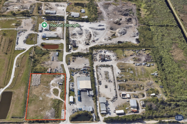
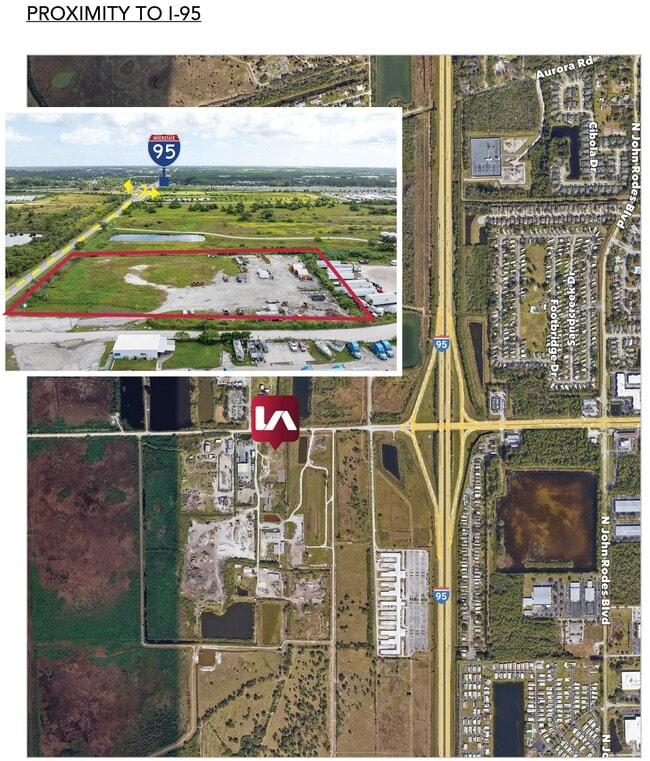
Property Record
1909 Unknown, Melbourne, FL 32934

Current Lease Availabilities
NEARBY LISTINGS FOR SALE OR LEASE
Property Detail
1909 Unknown
27-36-22-00-00752.0-0000.00
N 5 AC OF W 10 AC OF NW 1/4 OF SE 1/4 EXC RD R/W
Industrialacreage
Brevard
AE
Florida
12009C0577G
4.29 AC
2024
Brevard County
2025
Orlando
071354
Palm Bay-Melbourne-Titusville, FL
DEMOGRAPHICS near 1909 Unknown
1 Mile
3 Mile
5 Mile
2024 Total Population
2,478
22,390
76,648
2029 Population
2,923
26,533
90,865
Pop Growth 2024-2029
+ 17.96%
+ 18.50%
+ 18.55%
Average Age
44
45
43
2024 Total Households
973
9,358
32,134
HH Growth 2024-2029
+ 17.47%
+ 17.81%
+ 17.79%
Median Household Inc
$48,673
$73,515
$72,572
Avg Household Size
2.40
2.30
2.30
2024 Avg HH Vehicles
2.00
2.00
2.00
Median Home Value
$198,629
$277,871
$271,306
Median Year Built
1990
1985
1986
Nearby Places
Map Layers
Map Styles
 Street
 Aerial
- Restaurants
- Banks
- Shops
- Fitness
- Groceries
PUBLIC TRANSPORTATION
AIRPORT
Melbourne Orlando International
DRIVE
WALK
Distance
Melbourne Orlando International
15 min
7.0 mi
Freight Ports
Port Canaveral
DRIVE
WALK
Distance
Port Canaveral
40 min
32.1 mi
Nearby Properties
Address
Land Use
TOTAL SIZE
Lot Size
Zoning
Address
Land Use
TOTAL SIZE
Lot Size
Zoning
433,669 SF
21.22 AC
AU
Address
Land Use
TOTAL SIZE
Lot Size
Zoning
425,167 SF
43.33 AC
Address
Land Use
TOTAL SIZE
Lot Size
Zoning
81.17 AC
I1
Address
Land Use
TOTAL SIZE
Lot Size
Zoning
265,272 SF
21.17 AC
M1
Address
Land Use
TOTAL SIZE
Lot Size
Zoning
384,430 SF
33.07 AC
R2
Address
Land Use
TOTAL SIZE
Lot Size
Zoning
30.65 AC
I1
Address
Land Use
TOTAL SIZE
Lot Size
Zoning
389,175 SF
12.18 AC
Address
Land Use
TOTAL SIZE
Lot Size
Zoning
261,552 SF
23.21 AC
R2
Address
Land Use
TOTAL SIZE
Lot Size
Zoning
296,436 SF
28.05 AC
Address
Land Use
TOTAL SIZE
Lot Size
Zoning
196,130 SF
16 AC
Address
Land Use
TOTAL SIZE
Lot Size
Zoning
198,876 SF
64.32 AC
M1
Address
Land Use
TOTAL SIZE
Lot Size
Zoning
175,610 SF
10.01 AC
CCP(15)
Address
Land Use
TOTAL SIZE
Lot Size
Zoning
146,527 SF
42.12 AC
M-1
Address
Land Use
TOTAL SIZE
Lot Size
Zoning
196,340 SF
20.46 AC
CP
Address
Land Use
TOTAL SIZE
Lot Size
Zoning
92,119 SF
14.64 AC
I1
Address
Land Use
TOTAL SIZE
Lot Size
Zoning
111,696 SF
13.09 AC
CCP
Address
Land Use
TOTAL SIZE
Lot Size
Zoning
163,449 SF
11.20 AC
M1
Address
Land Use
TOTAL SIZE
Lot Size
Zoning
145,565 SF
15.97 AC
CP
Address
Land Use
TOTAL SIZE
Lot Size
Zoning
130,907 SF
20 AC
M1
Address
Land Use
TOTAL SIZE
Lot Size
Zoning
193,940 SF
38.87 AC
Address
Land Use
TOTAL SIZE
Lot Size
Zoning
119,111 SF
6.88 AC
M1
Address
Land Use
TOTAL SIZE
Lot Size
Zoning
74,304 SF
7.75 AC
CCP
Address
Land Use
TOTAL SIZE
Lot Size
Zoning
226,960 SF
21.49 AC
M1
Address
Land Use
TOTAL SIZE
Lot Size
Zoning
140,826 SF
15.93 AC
M1
Address
Land Use
TOTAL SIZE
Lot Size
Zoning
68,558 SF
7.17 AC
M2
Address
Land Use
TOTAL SIZE
Lot Size
Zoning
119,767 SF
7.10 AC
M1
Address
Land Use
TOTAL SIZE
Lot Size
Zoning
49,296 SF
2.94 AC
BU-1
Address
Land Use
TOTAL SIZE
Lot Size
Zoning
123,377 SF
16.21 AC
M1
Address
Land Use
TOTAL SIZE
Lot Size
Zoning
96,854 SF
7.51 AC
CP
Address
Land Use
TOTAL SIZE
Lot Size
Zoning
123,080 SF
10.02 AC
M1
The World's #1 Commercial Real Estate Marketplace
Connect with us
© 2025 CoStar Group
The information above has been obtained from sources believed reliable. While we do not doubt its accuracy we have not verified it and make no guarantee, warranty or representation about it. It is your responsibility to independently confirm its accuracy and completeness. Any projections, opinions, assumptions, or estimates used are for example only and do not represent the current or future performance of the property. The value of this transaction to you depends on tax and other factors which should be evaluated by your tax, financial, and legal advisors. You and your advisors should conduct a careful, independent investigation of the property to determine to your satisfaction the suitability of the property for your needs.