Property Record
1909 Unknown, Melbourne, FL 32940

Save to a Folder
{{folder.Name}}
{{folder.ListingIds.length}} Properties
{{folder.ListingIds.length}} Property
Create a New Folder
Property Detail
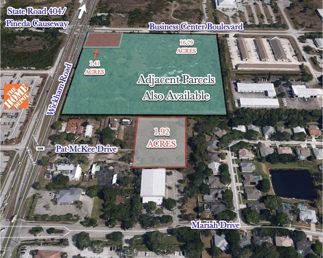
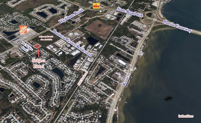
1909 Unknown
26-37-30-00-00516.0-0000.00
PART OF SW 1/4 AS DESC IN ORB 5401 PG 3144
Commercialacreage
BREVARD
C2
Florida
B and X Area of moderate flood hazard, usually the area between the limits of the 100-year and 500-year floods.
1.92 AC
2024
Brevard County
2025
Orlando
064127
Palm Bay-Melbourne-Titusville, FL
NEARBY LISTINGS FOR SALE OR LEASE
DEMOGRAPHICS near 1909 Unknown
1 mile
3 mile
5 mile
2025 Total Population
7,127
39,081
109,408
2030 Population
7,489
41,512
117,454
Pop Growth 2025-2030
+ 5.08%
+ 6.22%
+ 7.35%
Average Age
46
46
45
2025 Total Households
2,826
17,026
46,284
HH Growth 2025-2030
+ 4.78%
+ 5.91%
+ 6.88%
Median Household Inc
$116,980
$94,878
$93,011
Avg Household Size
2.50
2.30
2.30
2025 Avg HH Vehicles
2.00
2.00
2.00
Median Home Value
$441,395
$418,448
$440,465
Median Year Built
1996
1991
1989
Nearby Places
Map Layers
Map Styles
 Street
 Aerial
Layers
 Traffic
 Biking
Places
Listings with unknown addresses are not visible on the map
- Restaurants
- Banks
- Shops
- Fitness
- Groceries
PUBLIC TRANSPORTATION
AIRPORT
Melbourne Orlando International
Drive
Walk
Distance
Melbourne Orlando International
21 min
9.4 mi
Freight Ports
Port Canaveral
Drive
Walk
Distance
Port Canaveral
36 min
19.6 mi
SALE & LEASE HISTORY
LISTING DATE
SALE/LEASE

Nov 18, 2019
For Sale
Nearby Properties
Address
Land Use
TOTAL SIZE
Lot Size
Zoning
Address
Land Use
TOTAL SIZE
Lot Size
Zoning
676,548 SF
117.62 AC
I1
Address
Land Use
TOTAL SIZE
Lot Size
Zoning
438,381 SF
25.66 AC
R2
Address
Land Use
TOTAL SIZE
Lot Size
Zoning
354,864 SF
26.76 AC
PIP
Address
Land Use
TOTAL SIZE
Lot Size
Zoning
363,826 SF
25.61 AC
RA
Address
Land Use
TOTAL SIZE
Lot Size
Zoning
236,982 SF
39.26 AC
EU2
Address
Land Use
TOTAL SIZE
Lot Size
Zoning
360,921 SF
85.76 AC
R2
Address
Land Use
TOTAL SIZE
Lot Size
Zoning
269,111 SF
21.79 AC
PUD
Address
Land Use
TOTAL SIZE
Lot Size
Zoning
269,541 SF
17.80 AC
PUD
Address
Land Use
TOTAL SIZE
Lot Size
Zoning
216,446 SF
14.09 AC
R2
Address
Land Use
TOTAL SIZE
Lot Size
Zoning
222,779 SF
22.58 AC
R2
Address
Land Use
TOTAL SIZE
Lot Size
Zoning
188,093 SF
13.11 AC
R2
Address
Land Use
TOTAL SIZE
Lot Size
Zoning
227,172 SF
26.78 AC
BU1
Address
Land Use
TOTAL SIZE
Lot Size
Zoning
218,739 SF
11.23 AC
R2
Address
Land Use
TOTAL SIZE
Lot Size
Zoning
200,878 SF
16.41 AC
R2
Address
Land Use
TOTAL SIZE
Lot Size
Zoning
132,340 SF
14.58 AC
R2
Address
Land Use
TOTAL SIZE
Lot Size
Zoning
113,498 SF
37.57 AC
PUD
Address
Land Use
TOTAL SIZE
Lot Size
Zoning
142,230 SF
13.33 AC
C1
Address
Land Use
TOTAL SIZE
Lot Size
Zoning
133,137 SF
10.59 AC
PUD
Address
Land Use
TOTAL SIZE
Lot Size
Zoning
102,972 SF
18 AC
R2(6)
Address
Land Use
TOTAL SIZE
Lot Size
Zoning
162,629 SF
16.90 AC
Address
Land Use
TOTAL SIZE
Lot Size
Zoning
97,430 SF
51.89 AC
BU1
Address
Land Use
TOTAL SIZE
Lot Size
Zoning
171,773 SF
8.02 AC
R2
Address
Land Use
TOTAL SIZE
Lot Size
Zoning
184,197 SF
12 AC
R1AAA
Address
Land Use
TOTAL SIZE
Lot Size
Zoning
87,681 SF
11.53 AC
I1
Address
Land Use
TOTAL SIZE
Lot Size
Zoning
83,420 SF
5.94 AC
PUD
Address
Land Use
TOTAL SIZE
Lot Size
Zoning
91,470 SF
3.01 AC
BU1
Address
Land Use
TOTAL SIZE
Lot Size
Zoning
54,114 SF
11.48 AC
Address
Land Use
TOTAL SIZE
Lot Size
Zoning
120,600 SF
2.76 AC
Address
Land Use
TOTAL SIZE
Lot Size
Zoning
222,414 SF
13.13 AC
BU1
Address
Land Use
TOTAL SIZE
Lot Size
Zoning
82,494 SF
11.49 AC
BU1
The World's #1 Commercial Real Estate Marketplace
Connect with us
© 2026 CoStar Group
The information above has been obtained from sources believed reliable. While we do not doubt its accuracy we have not verified it and make no guarantee, warranty or representation about it. It is your responsibility to independently confirm its accuracy and completeness. Any projections, opinions, assumptions, or estimates used are for example only and do not represent the current or future performance of the property. The value of this transaction to you depends on tax and other factors which should be evaluated by your tax, financial, and legal advisors. You and your advisors should conduct a careful, independent investigation of the property to determine to your satisfaction the suitability of the property for your needs.