Property Record
1909 Unknown, Merritt Island, FL 32953
NEARBY LISTINGS FOR SALE OR LEASE
Property Detail
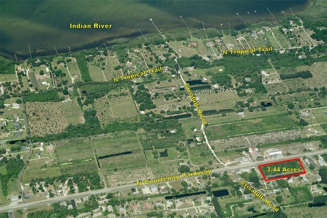
1909 Unknown
23-36-22-00-00767.0-0000.00
PART OF SE 1/4 OF SE 1/4 AS DESC IN DB 339 PG 82 EXC DB 425 PG 563, ORB 3110 PG 2480, ORB 9622 PG 2129 & RD R/W
Commercialacreage
Brevard
AE
Florida
12009C0329H
1.71 AC
2024
Brevard County
2025
Orlando
0699013206
Palm Bay-Melbourne-Titusville, FL
DEMOGRAPHICS near 1909 Unknown
1 Mile
3 Mile
5 Mile
2024 Total Population
1,457
6,785
23,939
2029 Population
1,613
7,439
26,161
Pop Growth 2024-2029
+ 10.71%
+ 9.64%
+ 9.28%
Average Age
44
47
45
2024 Total Households
560
2,733
9,900
HH Growth 2024-2029
+ 10.54%
+ 9.48%
+ 9.14%
Median Household Inc
$88,847
$106,879
$77,803
Avg Household Size
2.40
2.40
2.30
2024 Avg HH Vehicles
2.00
2.00
2.00
Median Home Value
$449,024
$440,075
$328,452
Median Year Built
1986
1993
1987
Nearby Places
Map Layers
Map Styles
 Street
 Aerial
- Restaurants
- Banks
- Shops
- Fitness
- Groceries
PUBLIC TRANSPORTATION
AIRPORT
Melbourne Orlando International
DRIVE
WALK
Distance
Melbourne Orlando International
48 min
37.5 mi
Freight Ports
Port Canaveral
DRIVE
WALK
Distance
Port Canaveral
1 min
7.3 mi
SALE & LEASE HISTORY
LISTING DATE
SALE/LEASE

Sep 24, 2016
For Sale
Nearby Properties
Address
Land Use
TOTAL SIZE
Lot Size
Zoning
Address
Land Use
TOTAL SIZE
Lot Size
Zoning
109.06 AC
EU-2
Address
Land Use
TOTAL SIZE
Lot Size
Zoning
63,106 SF
271.68 AC
INL
Address
Land Use
TOTAL SIZE
Lot Size
Zoning
15,320 SF
113.85 AC
AU
Address
Land Use
TOTAL SIZE
Lot Size
Zoning
53,465 SF
1.96 AC
PUD
Address
Land Use
TOTAL SIZE
Lot Size
Zoning
Address
Land Use
TOTAL SIZE
Lot Size
Zoning
550.47 AC
Address
Land Use
TOTAL SIZE
Lot Size
Zoning
95.81 AC
GML-H
Address
Land Use
TOTAL SIZE
Lot Size
Zoning
Address
Land Use
TOTAL SIZE
Lot Size
Zoning
24.27 AC
GML
Address
Land Use
TOTAL SIZE
Lot Size
Zoning
20,168 SF
8 AC
INL
Address
Land Use
TOTAL SIZE
Lot Size
Zoning
217.77 AC
AU
Address
Land Use
TOTAL SIZE
Lot Size
Zoning
21.59 AC
AU
Address
Land Use
TOTAL SIZE
Lot Size
Zoning
17,748 SF
21.12 AC
SR
Address
Land Use
TOTAL SIZE
Lot Size
Zoning
10,839 SF
5 AC
BU1A
Address
Land Use
TOTAL SIZE
Lot Size
Zoning
13,228 SF
11.99 AC
IN(L)
Address
Land Use
TOTAL SIZE
Lot Size
Zoning
9,582 SF
14.18 AC
AU
Address
Land Use
TOTAL SIZE
Lot Size
Zoning
12,100 SF
4.69 AC
IN(L)
Address
Land Use
TOTAL SIZE
Lot Size
Zoning
5,981 SF
4.53 AC
AU
Address
Land Use
TOTAL SIZE
Lot Size
Zoning
Address
Land Use
TOTAL SIZE
Lot Size
Zoning
9,400 SF
2 AC
Address
Land Use
TOTAL SIZE
Lot Size
Zoning
9,724 SF
1.84 AC
IN(L)
Address
Land Use
TOTAL SIZE
Lot Size
Zoning
13,600 SF
17.45 AC
IU
Address
Land Use
TOTAL SIZE
Lot Size
Zoning
62.16 AC
AU
Address
Land Use
TOTAL SIZE
Lot Size
Zoning
5,000 SF
2.98 AC
BU1
Address
Land Use
TOTAL SIZE
Lot Size
Zoning
7,276 SF
24.85 AC
AU
Address
Land Use
TOTAL SIZE
Lot Size
Zoning
6.33 AC
BU-1-A
Address
Land Use
TOTAL SIZE
Lot Size
Zoning
10,430 SF
5.61 AC
INL
Address
Land Use
TOTAL SIZE
Lot Size
Zoning
5,910 SF
2.60 AC
SR
Address
Land Use
TOTAL SIZE
Lot Size
Zoning
27,840 SF
5.86 AC
Address
Land Use
TOTAL SIZE
Lot Size
Zoning
13,616 SF
2.86 AC
BU1/BU2
The World's #1 Commercial Real Estate Marketplace
Connect with us
© 2025 CoStar Group
The information above has been obtained from sources believed reliable. While we do not doubt its accuracy we have not verified it and make no guarantee, warranty or representation about it. It is your responsibility to independently confirm its accuracy and completeness. Any projections, opinions, assumptions, or estimates used are for example only and do not represent the current or future performance of the property. The value of this transaction to you depends on tax and other factors which should be evaluated by your tax, financial, and legal advisors. You and your advisors should conduct a careful, independent investigation of the property to determine to your satisfaction the suitability of the property for your needs.