Property Record
1909 Unknown, Mims, FL 32754

Property Detail
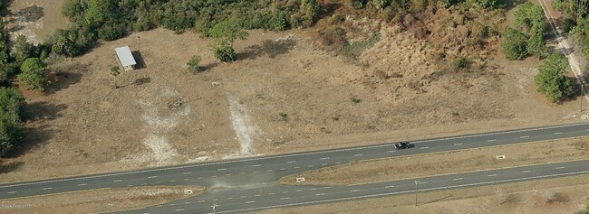
1909 Unknown
Palm Bay-Melbourne-Titusville, FL
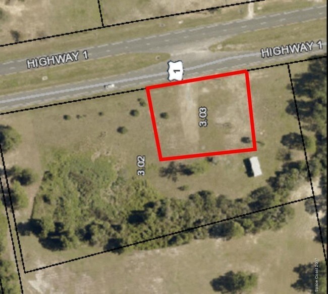
INDIAN RIVER PARK RESUBD PART OF PB 2 PG 106 DES AS TRACT 3 BLK 2 OF PB 2 PG 33 W OF US HWY 1 EX ORB 1701 PG 630
20G-35-20-MK-00000.0-0003.02
BREVARD
Commercialacreage
Florida
B and X Area of moderate flood hazard, usually the area between the limits of the 100-year and 500-year floods.
3
2024
3.36 AC
2025
Brevard County
0601011034
Orlando
NEARBY LISTINGS FOR SALE OR LEASE
-
-
View all Mims listings for sale on LoopNet.com
DEMOGRAPHICS near 1909 Unknown
1 mile
3 mile
5 mile
2025 Total Population
1,271
7,641
14,035
2030 Population
1,379
8,341
15,326
Pop Growth 2025-2030
+ 8.50%
+ 9.16%
+ 9.20%
Average Age
46
46
46
2025 Total Households
528
3,191
5,795
HH Growth 2025-2030
+ 7.95%
+ 8.90%
+ 9.01%
Median Household Inc
$76,172
$78,149
$75,085
Avg Household Size
2.40
2.30
2.40
2025 Avg HH Vehicles
2.00
2.00
2.00
Median Home Value
$393,381
$351,808
$325,465
Median Year Built
1987
1988
1988
Nearby Places
Map Layers
Map Styles
 Street
 Aerial
Transit
 Traffic
 Biking
Places
Listings with unknown addresses are not visible on the map
- Restaurants
- Banks
- Shops
- Fitness
- Groceries
SALE & LEASE HISTORY
LISTING DATE
SALE/LEASE

Jun 23, 2017
For Sale
Feb 13, 2017
For Sale
Nearby Properties
Address
Land Use
TOTAL SIZE
Lot Size
Zoning
Address
Land Use
TOTAL SIZE
Lot Size
Zoning
70,928 SF
15 AC
RU-1-9
Address
Land Use
TOTAL SIZE
Lot Size
Zoning
87.58 AC
GML
Address
Land Use
TOTAL SIZE
Lot Size
Zoning
1,800 SF
319.86 AC
AU
Address
Land Use
TOTAL SIZE
Lot Size
Zoning
36,557 SF
5.62 AC
IN(L)
Address
Land Use
TOTAL SIZE
Lot Size
Zoning
4,860 SF
10.38 AC
RVP
Address
Land Use
TOTAL SIZE
Lot Size
Zoning
4,164 SF
8.98 AC
RVP
Address
Land Use
TOTAL SIZE
Lot Size
Zoning
22,879 SF
6.48 AC
PUD
Address
Land Use
TOTAL SIZE
Lot Size
Zoning
9,100 SF
1.48 AC
BU-1
Address
Land Use
TOTAL SIZE
Lot Size
Zoning
22,155 SF
2.18 AC
BU2
Address
Land Use
TOTAL SIZE
Lot Size
Zoning
7,598 SF
3.02 AC
GML
Address
Land Use
TOTAL SIZE
Lot Size
Zoning
133.98 AC
PUD
Address
Land Use
TOTAL SIZE
Lot Size
Zoning
9,250 SF
28.63 AC
INL
Address
Land Use
TOTAL SIZE
Lot Size
Zoning
59.45 AC
RU-1-11
Address
Land Use
TOTAL SIZE
Lot Size
Zoning
9,600 SF
6.56 AC
BU-1
Address
Land Use
TOTAL SIZE
Lot Size
Zoning
163.33 AC
PUD
Address
Land Use
TOTAL SIZE
Lot Size
Zoning
9,395 SF
1.82 AC
BU-2
Address
Land Use
TOTAL SIZE
Lot Size
Zoning
5,311 SF
7.24 AC
AU
Address
Land Use
TOTAL SIZE
Lot Size
Zoning
8,016 SF
5 AC
AU
Address
Land Use
TOTAL SIZE
Lot Size
Zoning
122.24 AC
RRMH-1
Address
Land Use
TOTAL SIZE
Lot Size
Zoning
4,209 SF
39.08 AC
AU
Address
Land Use
TOTAL SIZE
Lot Size
Zoning
9,500 SF
5 AC
AU
Address
Land Use
TOTAL SIZE
Lot Size
Zoning
70.31 AC
PUD
Address
Land Use
TOTAL SIZE
Lot Size
Zoning
205.20 AC
GML(H)
Address
Land Use
TOTAL SIZE
Lot Size
Zoning
9,624 SF
5.13 AC
BU1
Address
Land Use
TOTAL SIZE
Lot Size
Zoning
3,934 SF
5.78 AC
AU
Address
Land Use
TOTAL SIZE
Lot Size
Zoning
8,534 SF
19.47 AC
AU
Address
Land Use
TOTAL SIZE
Lot Size
Zoning
7,026 SF
2.26 AC
BU-1
Address
Land Use
TOTAL SIZE
Lot Size
Zoning
60.21 AC
PUD
Address
Land Use
TOTAL SIZE
Lot Size
Zoning
4,431 SF
15 AC
RRMH-2.5
Address
Land Use
TOTAL SIZE
Lot Size
Zoning
12,818 SF
1.83 AC
BU1
The World's #1 Commercial Real Estate Marketplace
Connect with us
© 2026 CoStar Group
The information above has been obtained from sources believed reliable. While we do not doubt its accuracy we have not verified it and make no guarantee, warranty or representation about it. It is your responsibility to independently confirm its accuracy and completeness. Any projections, opinions, assumptions, or estimates used are for example only and do not represent the current or future performance of the property. The value of this transaction to you depends on tax and other factors which should be evaluated by your tax, financial, and legal advisors. You and your advisors should conduct a careful, independent investigation of the property to determine to your satisfaction the suitability of the property for your needs.