Property Record
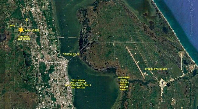
1909 Unknown, Mims, FL 32754


Property Detail
1909 Unknown
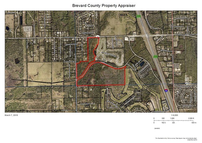
21-34-13-00-00506.0-0000.00
PART OF SW 1/4 OF SECT AS DESC IN ORB 5439 PG 860 & PART OF SW 1/4 OF SE 1/4 DESC AS PAR 2 WITHIN ORB 6177 PG 1
Livestock
BREVARD
RU-1-11
Florida
B and X Area of moderate flood hazard, usually the area between the limits of the 100-year and 500-year floods.
79.16 AC
2024
Brevard County
2025
Orlando
060201
Palm Bay-Melbourne-Titusville, FL
NEARBY LISTINGS FOR SALE OR LEASE
DEMOGRAPHICS near 1909 Unknown
1 mile
3 mile
5 mile
2025 Total Population
3,223
17,922
31,630
2030 Population
3,498
19,498
34,269
Pop Growth 2025-2030
+ 8.53%
+ 8.79%
+ 8.34%
Average Age
46
45
45
2025 Total Households
1,304
7,357
12,946
HH Growth 2025-2030
+ 8.21%
+ 8.59%
+ 8.11%
Median Household Inc
$87,442
$74,865
$73,127
Avg Household Size
2.40
2.40
2.30
2025 Avg HH Vehicles
2.00
2.00
2.00
Median Home Value
$328,823
$286,523
$291,902
Median Year Built
1987
1985
1983
Nearby Places
Map Layers
Map Styles
 Street
 Aerial
Layers
 Traffic
 Biking
Places
Listings with unknown addresses are not visible on the map
- Restaurants
- Banks
- Shops
- Fitness
- Groceries
PUBLIC TRANSPORTATION
AIRPORT
Orlando Sanford International
Drive
Walk
Distance
Orlando Sanford International
70 min
49.6 mi
Freight Ports
Port Canaveral
Drive
Walk
Distance
Port Canaveral
41 min
32.4 mi
SALE & LEASE HISTORY
LISTING DATE
SALE/LEASE

Oct 25, 2019
For Sale
Nearby Properties
Address
Land Use
TOTAL SIZE
Lot Size
Zoning
Address
Land Use
TOTAL SIZE
Lot Size
Zoning
267,207 SF
36.82 AC
P
Address
Land Use
TOTAL SIZE
Lot Size
Zoning
87,904 SF
13.16 AC
RU19
Address
Land Use
TOTAL SIZE
Lot Size
Zoning
113,576 SF
19.98 AC
P
Address
Land Use
TOTAL SIZE
Lot Size
Zoning
46.75 AC
GML
Address
Land Use
TOTAL SIZE
Lot Size
Zoning
97,463 SF
19.50 AC
P
Address
Land Use
TOTAL SIZE
Lot Size
Zoning
10,248 SF
41.06 AC
RU-1-7
Address
Land Use
TOTAL SIZE
Lot Size
Zoning
87,836 SF
8.89 AC
CC
Address
Land Use
TOTAL SIZE
Lot Size
Zoning
24,364 SF
14.08 AC
Address
Land Use
TOTAL SIZE
Lot Size
Zoning
114.31 AC
GU
Address
Land Use
TOTAL SIZE
Lot Size
Zoning
87.58 AC
GML
Address
Land Use
TOTAL SIZE
Lot Size
Zoning
9,961 SF
13.71 AC
RVP
Address
Land Use
TOTAL SIZE
Lot Size
Zoning
21,934 SF
8.05 AC
BU-1
Address
Land Use
TOTAL SIZE
Lot Size
Zoning
37,971 SF
11.86 AC
GML
Address
Land Use
TOTAL SIZE
Lot Size
Zoning
17,815 SF
2.21 AC
BU-1
Address
Land Use
TOTAL SIZE
Lot Size
Zoning
22,445 SF
16.19 AC
INL
Address
Land Use
TOTAL SIZE
Lot Size
Zoning
19,137 SF
5.91 AC
BU-1
Address
Land Use
TOTAL SIZE
Lot Size
Zoning
24,088 SF
9.50 AC
IN(L)
Address
Land Use
TOTAL SIZE
Lot Size
Zoning
17,042 SF
2.75 AC
BU2
Address
Land Use
TOTAL SIZE
Lot Size
Zoning
4,860 SF
10.38 AC
RVP
Address
Land Use
TOTAL SIZE
Lot Size
Zoning
73,022 SF
5.34 AC
IU
Address
Land Use
TOTAL SIZE
Lot Size
Zoning
4,164 SF
8.98 AC
RVP
Address
Land Use
TOTAL SIZE
Lot Size
Zoning
0.80 AC
GML
Address
Land Use
TOTAL SIZE
Lot Size
Zoning
22,879 SF
6.48 AC
PUD
Address
Land Use
TOTAL SIZE
Lot Size
Zoning
10,291 SF
10.45 AC
BU-2
Address
Land Use
TOTAL SIZE
Lot Size
Zoning
24,656 SF
6.69 AC
BU1BU2
Address
Land Use
TOTAL SIZE
Lot Size
Zoning
5,873 SF
11.67 AC
AU
Address
Land Use
TOTAL SIZE
Lot Size
Zoning
10,060 SF
5.35 AC
CC
Address
Land Use
TOTAL SIZE
Lot Size
Zoning
35,064 SF
4.64 AC
IN(L)
Address
Land Use
TOTAL SIZE
Lot Size
Zoning
19,580 SF
4.97 AC
BU2
The World's #1 Commercial Real Estate Marketplace
Connect with us
© 2026 CoStar Group
The information above has been obtained from sources believed reliable. While we do not doubt its accuracy we have not verified it and make no guarantee, warranty or representation about it. It is your responsibility to independently confirm its accuracy and completeness. Any projections, opinions, assumptions, or estimates used are for example only and do not represent the current or future performance of the property. The value of this transaction to you depends on tax and other factors which should be evaluated by your tax, financial, and legal advisors. You and your advisors should conduct a careful, independent investigation of the property to determine to your satisfaction the suitability of the property for your needs.