Property Record
1909 Unknown, Mims, FL 32754

Save to a Folder
{{folder.Name}}
{{folder.ListingIds.length}} Properties
{{folder.ListingIds.length}} Property
Create a New Folder
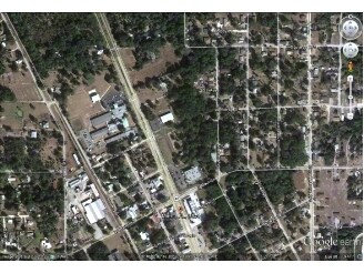
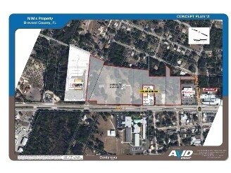
Property Detail
1909 Unknown
Palm Bay-Melbourne-Titusville, FL
PART OF NW 1/4 AS DESC IN DB 56 PG 175 EXC LAND AS DESC IN DB 335 PG 555, 328 PG 502 & RD R/W
21-35-17-00-00301.0-0000.00
BREVARD
Commercialacreage
Florida
B and X Area of moderate flood hazard, usually the area between the limits of the 100-year and 500-year floods.
1.94 AC
2025
Brevard County
2025
Orlando
060105
NEARBY LISTINGS FOR SALE OR LEASE
DEMOGRAPHICS near 1909 Unknown
1 mile
3 mile
5 mile
2025 Total Population
2,180
19,696
35,968
2030 Population
2,418
21,378
38,943
Pop Growth 2025-2030
+ 10.92%
+ 8.54%
+ 8.27%
Average Age
47
46
45
2025 Total Households
929
8,099
14,882
HH Growth 2025-2030
+ 10.98%
+ 8.36%
+ 8.02%
Median Household Inc
$51,269
$71,473
$69,217
Avg Household Size
2.30
2.40
2.30
2025 Avg HH Vehicles
2.00
2.00
2.00
Median Home Value
$238,889
$280,655
$294,640
Median Year Built
1987
1983
1983
Nearby Places
Map Layers
Map Styles
 Street
 Aerial
Layers
 Traffic
 Biking
Places
Listings with unknown addresses are not visible on the map
- Restaurants
- Banks
- Shops
- Fitness
- Groceries
SALE & LEASE HISTORY
LISTING DATE
SALE/LEASE

Apr 06, 2017
For Sale
Nearby Properties
Address
Land Use
TOTAL SIZE
Lot Size
Zoning
Address
Land Use
TOTAL SIZE
Lot Size
Zoning
172,172 SF
116.12 AC
P
Address
Land Use
TOTAL SIZE
Lot Size
Zoning
87,904 SF
13.16 AC
RU19
Address
Land Use
TOTAL SIZE
Lot Size
Zoning
54,816 SF
10.11 AC
BU-1
Address
Land Use
TOTAL SIZE
Lot Size
Zoning
113,576 SF
19.98 AC
P
Address
Land Use
TOTAL SIZE
Lot Size
Zoning
46.75 AC
GML
Address
Land Use
TOTAL SIZE
Lot Size
Zoning
70,928 SF
15 AC
RU-1-9
Address
Land Use
TOTAL SIZE
Lot Size
Zoning
97,463 SF
19.50 AC
P
Address
Land Use
TOTAL SIZE
Lot Size
Zoning
10,248 SF
41.06 AC
RU-1-7
Address
Land Use
TOTAL SIZE
Lot Size
Zoning
87,836 SF
8.89 AC
CC
Address
Land Use
TOTAL SIZE
Lot Size
Zoning
24,364 SF
14.08 AC
Address
Land Use
TOTAL SIZE
Lot Size
Zoning
114.31 AC
GU
Address
Land Use
TOTAL SIZE
Lot Size
Zoning
63,506 SF
18.94 AC
GU
Address
Land Use
TOTAL SIZE
Lot Size
Zoning
87.58 AC
GML
Address
Land Use
TOTAL SIZE
Lot Size
Zoning
9,961 SF
13.71 AC
RVP
Address
Land Use
TOTAL SIZE
Lot Size
Zoning
21,934 SF
8.05 AC
BU-1
Address
Land Use
TOTAL SIZE
Lot Size
Zoning
37,971 SF
11.86 AC
GML
Address
Land Use
TOTAL SIZE
Lot Size
Zoning
17,815 SF
2.21 AC
BU-1
Address
Land Use
TOTAL SIZE
Lot Size
Zoning
22,445 SF
16.19 AC
INL
Address
Land Use
TOTAL SIZE
Lot Size
Zoning
11,486 SF
88 AC
RRMH1
Address
Land Use
TOTAL SIZE
Lot Size
Zoning
31.19 AC
AU
Address
Land Use
TOTAL SIZE
Lot Size
Zoning
19,137 SF
5.91 AC
BU-1
Address
Land Use
TOTAL SIZE
Lot Size
Zoning
24,088 SF
9.50 AC
IN(L)
Address
Land Use
TOTAL SIZE
Lot Size
Zoning
17,042 SF
2.75 AC
BU2
Address
Land Use
TOTAL SIZE
Lot Size
Zoning
4,860 SF
10.38 AC
RVP
Address
Land Use
TOTAL SIZE
Lot Size
Zoning
79.16 AC
RU-1-11
Address
Land Use
TOTAL SIZE
Lot Size
Zoning
73,022 SF
5.34 AC
IU
Address
Land Use
TOTAL SIZE
Lot Size
Zoning
4,164 SF
8.98 AC
RVP
Address
Land Use
TOTAL SIZE
Lot Size
Zoning
40,455 SF
13.75 AC
PIP
Address
Land Use
TOTAL SIZE
Lot Size
Zoning
0.80 AC
GML
Address
Land Use
TOTAL SIZE
Lot Size
Zoning
22,879 SF
6.48 AC
PUD
The World's #1 Commercial Real Estate Marketplace
Connect with us
© 2026 CoStar Group
The information above has been obtained from sources believed reliable. While we do not doubt its accuracy we have not verified it and make no guarantee, warranty or representation about it. It is your responsibility to independently confirm its accuracy and completeness. Any projections, opinions, assumptions, or estimates used are for example only and do not represent the current or future performance of the property. The value of this transaction to you depends on tax and other factors which should be evaluated by your tax, financial, and legal advisors. You and your advisors should conduct a careful, independent investigation of the property to determine to your satisfaction the suitability of the property for your needs.