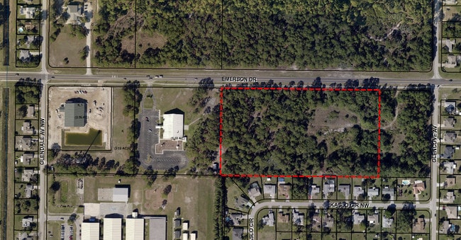
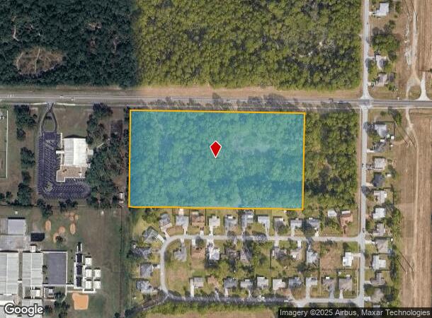
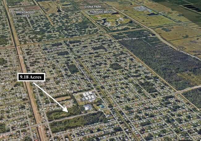
Property Record
1909 Unknown, Palm Bay, FL 32907

NEARBY LISTINGS FOR SALE OR LEASE
Property Detail
1909 Unknown
Palm Bay-Melbourne-Titusville, FL
Port Malabar Unit 44
28-36-22-KO-0000I.0-0000.00
PORT MALABAR UNIT 44 TRACT I EXC ORB 4185 PG 2747
Commercialacreage
Brevard
X
Florida
12009C0590G
9.18 AC
2024
Brevard County
2025
Orlando
0713382024
DEMOGRAPHICS near 1909 Unknown
1 Mile
3 Mile
5 Mile
2024 Total Population
8,840
37,373
94,846
2029 Population
9,574
41,010
104,120
Pop Growth 2024-2029
+ 8.30%
+ 9.73%
+ 9.78%
Average Age
42
41
42
2024 Total Households
3,174
13,223
36,155
HH Growth 2024-2029
+ 8.10%
+ 9.48%
+ 9.59%
Median Household Inc
$62,674
$67,454
$66,324
Avg Household Size
2.70
2.80
2.60
2024 Avg HH Vehicles
2.00
2.00
2.00
Median Home Value
$191,693
$225,920
$238,596
Median Year Built
1988
1993
1994
Nearby Places
Map Layers
Map Styles
 Street
 Aerial
- Restaurants
- Banks
- Shops
- Fitness
- Groceries
PUBLIC TRANSPORTATION
AIRPORT
Melbourne Orlando International
DRIVE
WALK
Distance
Melbourne Orlando International
22 min
9.7 mi
Freight Ports
Port Canaveral
DRIVE
WALK
Distance
Port Canaveral
52 min
40.1 mi
SALE & LEASE HISTORY
LISTING DATE
SALE/LEASE

Sep 24, 2016
For Sale
Nearby Properties
Address
Land Use
TOTAL SIZE
Lot Size
Zoning
Address
Land Use
TOTAL SIZE
Lot Size
Zoning
380,944 SF
32.18 AC
RA
Address
Land Use
TOTAL SIZE
Lot Size
Zoning
341,488 SF
66 AC
GU
Address
Land Use
TOTAL SIZE
Lot Size
Zoning
321,761 SF
21.27 AC
RM15
Address
Land Use
TOTAL SIZE
Lot Size
Zoning
297,886 SF
32.38 AC
C-1
Address
Land Use
TOTAL SIZE
Lot Size
Zoning
95,944 SF
17.22 AC
GU
Address
Land Use
TOTAL SIZE
Lot Size
Zoning
110,455 SF
17.83 AC
IU
Address
Land Use
TOTAL SIZE
Lot Size
Zoning
29,933 SF
200 AC
GU
Address
Land Use
TOTAL SIZE
Lot Size
Zoning
123,275 SF
13.22 AC
IU
Address
Land Use
TOTAL SIZE
Lot Size
Zoning
85,125 SF
13.06 AC
C1
Address
Land Use
TOTAL SIZE
Lot Size
Zoning
38,455 SF
136.27 AC
RU113
Address
Land Use
TOTAL SIZE
Lot Size
Zoning
40,216 SF
8.97 AC
NC
Address
Land Use
TOTAL SIZE
Lot Size
Zoning
50,041 SF
2.59 AC
CC
Address
Land Use
TOTAL SIZE
Lot Size
Zoning
28,592 SF
2.99 AC
BU-1
Address
Land Use
TOTAL SIZE
Lot Size
Zoning
50,971 SF
5.68 AC
IU
Address
Land Use
TOTAL SIZE
Lot Size
Zoning
586.26 AC
GU
Address
Land Use
TOTAL SIZE
Lot Size
Zoning
568.83 AC
GU
Address
Land Use
TOTAL SIZE
Lot Size
Zoning
640 AC
IU
Address
Land Use
TOTAL SIZE
Lot Size
Zoning
11.14 AC
Address
Land Use
TOTAL SIZE
Lot Size
Zoning
17,017 SF
2.09 AC
BU-1
Address
Land Use
TOTAL SIZE
Lot Size
Zoning
13,542 SF
2.69 AC
IU
Address
Land Use
TOTAL SIZE
Lot Size
Zoning
Address
Land Use
TOTAL SIZE
Lot Size
Zoning
26,353 SF
4.10 AC
RA
Address
Land Use
TOTAL SIZE
Lot Size
Zoning
28,255 SF
15.54 AC
IU
Address
Land Use
TOTAL SIZE
Lot Size
Zoning
5,600 SF
2.24 AC
C2
Address
Land Use
TOTAL SIZE
Lot Size
Zoning
6,631 SF
1.82 AC
RA
Address
Land Use
TOTAL SIZE
Lot Size
Zoning
27.90 AC
AU
Address
Land Use
TOTAL SIZE
Lot Size
Zoning
12,903 SF
1.31 AC
CC
Address
Land Use
TOTAL SIZE
Lot Size
Zoning
18,634 SF
5.82 AC
IU
Address
Land Use
TOTAL SIZE
Lot Size
Zoning
15,224 SF
1.26 AC
CC
Address
Land Use
TOTAL SIZE
Lot Size
Zoning
6,892 SF
3.11 AC
NC
The World's #1 Commercial Real Estate Marketplace
Connect with us
© 2026 CoStar Group
The information above has been obtained from sources believed reliable. While we do not doubt its accuracy we have not verified it and make no guarantee, warranty or representation about it. It is your responsibility to independently confirm its accuracy and completeness. Any projections, opinions, assumptions, or estimates used are for example only and do not represent the current or future performance of the property. The value of this transaction to you depends on tax and other factors which should be evaluated by your tax, financial, and legal advisors. You and your advisors should conduct a careful, independent investigation of the property to determine to your satisfaction the suitability of the property for your needs.