Property Record
1909 Unknown, Titusville, FL 32780

NEARBY LISTINGS FOR SALE OR LEASE
Property Detail
1909 Unknown
Palm Bay-Melbourne-Titusville, FL
Titusville Fruit & Farm Land Co
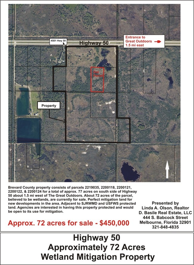
22-34-25-AV-00000.0-0073.00
TITUSVILLE FRUIT & FARM LAND CO LOTS 73 THRU 76, 85, 86, 107, 108, 117, 118, 119 & 120 EXC HWY R/W
Residentialacreage
Brevard
AE
Florida
12009C0215G
73
2024
54.03 AC
2025
Brevard County
0711002003
Orlando
DEMOGRAPHICS near 1909 Unknown
1 Mile
3 Mile
5 Mile
2024 Total Population
5
8,383
39,786
2029 Population
6
9,196
43,513
Pop Growth 2024-2029
+ 20.00%
+ 9.70%
+ 9.37%
Average Age
75
54
46
2024 Total Households
3
3,837
17,420
HH Growth 2024-2029
0.00%
+ 9.75%
+ 9.22%
Median Household Inc
$0
$81,980
$62,448
Avg Household Size
1.70
2.10
2.20
2024 Avg HH Vehicles
1.00
2.00
2.00
Median Home Value
$399,999
$289,990
$242,127
Median Year Built
1999
1994
1985
Nearby Places
Map Layers
Map Styles
 Street
 Aerial
- Restaurants
- Banks
- Shops
- Fitness
- Groceries
PUBLIC TRANSPORTATION
AIRPORT
Orlando International
DRIVE
WALK
Distance
Orlando International
44 min
37.2 mi
Orlando Sanford International
DRIVE
WALK
Distance
Orlando Sanford International
57 min
39.5 mi
Freight Ports
Port Canaveral
DRIVE
WALK
Distance
Port Canaveral
32 min
24.8 mi
SALE & LEASE HISTORY
LISTING DATE
SALE/LEASE

Sep 24, 2016
For Sale
Nearby Properties
Address
Land Use
TOTAL SIZE
Lot Size
Zoning
Address
Land Use
TOTAL SIZE
Lot Size
Zoning
387,000 SF
55.44 AC
R2
Address
Land Use
TOTAL SIZE
Lot Size
Zoning
85,228 SF
15.35 AC
CC
Address
Land Use
TOTAL SIZE
Lot Size
Zoning
208,047 SF
18.89 AC
RC
Address
Land Use
TOTAL SIZE
Lot Size
Zoning
108,338 SF
16.23 AC
Address
Land Use
TOTAL SIZE
Lot Size
Zoning
80.58 AC
RVP
Address
Land Use
TOTAL SIZE
Lot Size
Zoning
80,453 SF
3.19 AC
T
Address
Land Use
TOTAL SIZE
Lot Size
Zoning
58,697 SF
2.89 AC
TU2
Address
Land Use
TOTAL SIZE
Lot Size
Zoning
127,083 SF
10.53 AC
CC
Address
Land Use
TOTAL SIZE
Lot Size
Zoning
53,937 SF
2.65 AC
T
Address
Land Use
TOTAL SIZE
Lot Size
Zoning
158,447 SF
23.98 AC
BU2
Address
Land Use
TOTAL SIZE
Lot Size
Zoning
48,510 SF
1.99 AC
T
Address
Land Use
TOTAL SIZE
Lot Size
Zoning
97,504 SF
14.70 AC
OR
Address
Land Use
TOTAL SIZE
Lot Size
Zoning
53,989 SF
3.53 AC
Address
Land Use
TOTAL SIZE
Lot Size
Zoning
107,338 SF
15.82 AC
RC
Address
Land Use
TOTAL SIZE
Lot Size
Zoning
81,837 SF
2.69 AC
Address
Land Use
TOTAL SIZE
Lot Size
Zoning
83,134 SF
4.17 AC
T
Address
Land Use
TOTAL SIZE
Lot Size
Zoning
49,025 SF
5.70 AC
CC
Address
Land Use
TOTAL SIZE
Lot Size
Zoning
76,413 SF
4.14 AC
T
Address
Land Use
TOTAL SIZE
Lot Size
Zoning
56,837 SF
3.17 AC
T
Address
Land Use
TOTAL SIZE
Lot Size
Zoning
38,612 SF
13.19 AC
CC
Address
Land Use
TOTAL SIZE
Lot Size
Zoning
87,550 SF
8.71 AC
M3
Address
Land Use
TOTAL SIZE
Lot Size
Zoning
74,103 SF
4.21 AC
M3
Address
Land Use
TOTAL SIZE
Lot Size
Zoning
32,319 SF
5.49 AC
RC
Address
Land Use
TOTAL SIZE
Lot Size
Zoning
43,200 SF
4.52 AC
R2
Address
Land Use
TOTAL SIZE
Lot Size
Zoning
73,497 SF
5.06 AC
T
Address
Land Use
TOTAL SIZE
Lot Size
Zoning
4,489 SF
3.41 AC
Address
Land Use
TOTAL SIZE
Lot Size
Zoning
10,491 SF
4 AC
RC
Address
Land Use
TOTAL SIZE
Lot Size
Zoning
57,527 SF
6.23 AC
M1
Address
Land Use
TOTAL SIZE
Lot Size
Zoning
24,532 SF
2.89 AC
RC
Address
Land Use
TOTAL SIZE
Lot Size
Zoning
17,988 SF
3.02 AC
RC
The World's #1 Commercial Real Estate Marketplace
Connect with us
© 2026 CoStar Group
The information above has been obtained from sources believed reliable. While we do not doubt its accuracy we have not verified it and make no guarantee, warranty or representation about it. It is your responsibility to independently confirm its accuracy and completeness. Any projections, opinions, assumptions, or estimates used are for example only and do not represent the current or future performance of the property. The value of this transaction to you depends on tax and other factors which should be evaluated by your tax, financial, and legal advisors. You and your advisors should conduct a careful, independent investigation of the property to determine to your satisfaction the suitability of the property for your needs.