Property Record
191 Cooper Hill Rd, Windsor, NC 27983
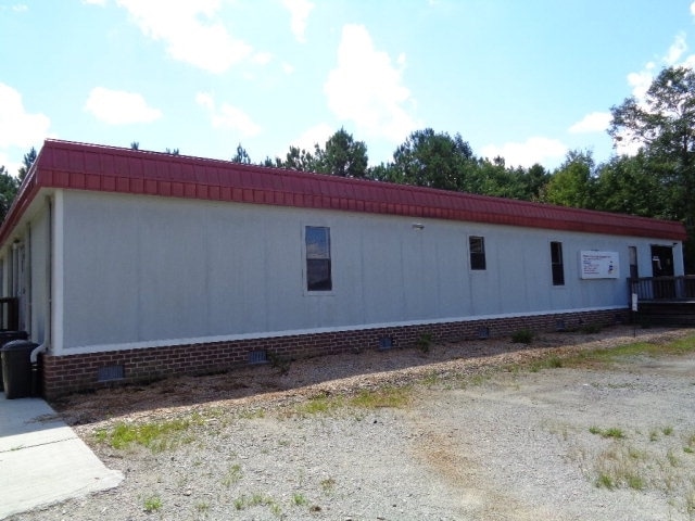

Property Detail
191 Cooper Hill Rd
Daycare
CONNER SANDERLIN
R-10 SINGL
Bertie
B and X Area of moderate flood hazard, usually the area between the limits of the 100-year and 500-year floods.
North Carolina
2025
2 AC
2025
Other Market Areas
960402
6811-77-6739
3,857 SF
NEARBY LISTINGS FOR SALE OR LEASE
-
-
View all Windsor listings for sale on LoopNet.com
DEMOGRAPHICS near 191 Cooper Hill Rd
1 mile
3 mile
5 mile
2025 Total Population
301
2,877
4,501
2030 Population
301
2,874
4,500
Pop Growth 2025-2030
0.00%
(0.10%)
(0.02%)
Average Age
45
46
46
2025 Total Households
108
1,223
1,945
HH Growth 2025-2030
+ 0.93%
(0.08%)
(0.05%)
Median Household Inc
$44,166
$40,700
$43,264
Avg Household Size
2.40
2.20
2.20
2025 Avg HH Vehicles
2.00
2.00
2.00
Median Home Value
$150,000
$123,092
$128,798
Median Year Built
1987
1977
1977
Nearby Places
Map Layers
Map Styles
 Street
 Aerial
Layers
 Traffic
 Biking
Places
Listings with unknown addresses are not visible on the map
- Restaurants
- Banks
- Shops
- Fitness
- Groceries
SALE & LEASE HISTORY
LISTING DATE
SALE/LEASE

Oct 26, 2016
For Sale
Mar 24, 2018
For Sale
Mar 05, 2020
For Sale
Nearby Properties
Address
Land Use
TOTAL SIZE
Lot Size
Zoning
Address
Land Use
TOTAL SIZE
Lot Size
Zoning
400,006 SF
130.31 AC
RA-20 SING
Address
Land Use
TOTAL SIZE
Lot Size
Zoning
6.86 AC
HIGHWAY CO
Address
Land Use
TOTAL SIZE
Lot Size
Zoning
45,619 SF
7.37 AC
R-5MH SING
Address
Land Use
TOTAL SIZE
Lot Size
Zoning
9,464 SF
1.92 AC
CENTRAL BU
Address
Land Use
TOTAL SIZE
Lot Size
Zoning
10,964 SF
2.61 AC
MANUFACTUR
Address
Land Use
TOTAL SIZE
Lot Size
Zoning
6.33 AC
R-5MH SING
Address
Land Use
TOTAL SIZE
Lot Size
Zoning
21,622 SF
13.79 AC
HIGHWAY CO
Address
Land Use
TOTAL SIZE
Lot Size
Zoning
1,800 SF
3.94 AC
R-5MH SING
Address
Land Use
TOTAL SIZE
Lot Size
Zoning
25,710 SF
5.56 AC
RA-20 SING
Address
Land Use
TOTAL SIZE
Lot Size
Zoning
1,427 SF
4.47 AC
HIGHWAY CO
Address
Land Use
TOTAL SIZE
Lot Size
Zoning
1,698 SF
10 AC
RA-20 SING
Address
Land Use
TOTAL SIZE
Lot Size
Zoning
900 SF
6.76 AC
R-5 SINGLE
Address
Land Use
TOTAL SIZE
Lot Size
Zoning
132 SF
1.50 AC
R-5 SINGLE
Address
Land Use
TOTAL SIZE
Lot Size
Zoning
210 SF
1.34 AC
HIGHWAY CO
Address
Land Use
TOTAL SIZE
Lot Size
Zoning
6,000 SF
15.73 AC
MANUFACTUR
Address
Land Use
TOTAL SIZE
Lot Size
Zoning
2.63 AC
HIGHWAY CO
Address
Land Use
TOTAL SIZE
Lot Size
Zoning
9,171 SF
1.96 AC
R-10 SINGL
Address
Land Use
TOTAL SIZE
Lot Size
Zoning
9,085 SF
0.76 AC
HIGHWAY CO
Address
Land Use
TOTAL SIZE
Lot Size
Zoning
1,396.29 AC
RA-20 SING
Address
Land Use
TOTAL SIZE
Lot Size
Zoning
6,666 SF
3.59 AC
OFFICE & I
Address
Land Use
TOTAL SIZE
Lot Size
Zoning
200 SF
1.12 AC
CENTRAL BU
Address
Land Use
TOTAL SIZE
Lot Size
Zoning
6,149 SF
4.54 AC
HIGHWAY CO
Address
Land Use
TOTAL SIZE
Lot Size
Zoning
50.11 AC
Address
Land Use
TOTAL SIZE
Lot Size
Zoning
1,176 SF
17.83 AC
MANUFACTUR
Address
Land Use
TOTAL SIZE
Lot Size
Zoning
147.58 AC
MANUFACTUR
Address
Land Use
TOTAL SIZE
Lot Size
Zoning
6,698 SF
0.69 AC
HIGHWAY CO
Address
Land Use
TOTAL SIZE
Lot Size
Zoning
385.19 AC
Address
Land Use
TOTAL SIZE
Lot Size
Zoning
330 SF
0.99 AC
R-5 SINGLE
Address
Land Use
TOTAL SIZE
Lot Size
Zoning
527.14 AC
Address
Land Use
TOTAL SIZE
Lot Size
Zoning
7,545 SF
1.16 AC
R-5 SINGLE
The World's #1 Commercial Real Estate Marketplace
Connect with us
© 2026 CoStar Group
The information above has been obtained from sources believed reliable. While we do not doubt its accuracy we have not verified it and make no guarantee, warranty or representation about it. It is your responsibility to independently confirm its accuracy and completeness. Any projections, opinions, assumptions, or estimates used are for example only and do not represent the current or future performance of the property. The value of this transaction to you depends on tax and other factors which should be evaluated by your tax, financial, and legal advisors. You and your advisors should conduct a careful, independent investigation of the property to determine to your satisfaction the suitability of the property for your needs.