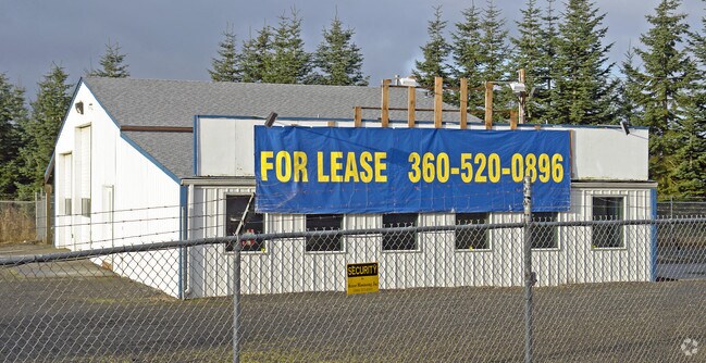
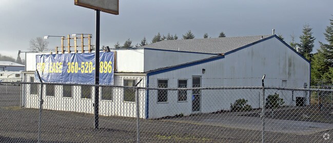
Property Record
191 Hamilton Rd, Chehalis, WA 98532

Save to a Folder
{{folder.Name}}
{{folder.ListingIds.length}} Properties
{{folder.ListingIds.length}} Property
Create a New Folder
Property Detail
191 Hamilton Rd
017905-004-000
SECTION 15 TOWNSHIP 13N RANGE 02W TRI SWLY FRONTAGE RD PTN NE4 SE4
Storebuilding
Lewis
C
Washington
B and X Area of moderate flood hazard, usually the area between the limits of the 100-year and 500-year floods.
0.25 AC
2024
Washington State Area
2025
Other Market Areas
971400
Centralia, WA
3,492 SF
NEARBY LISTINGS FOR SALE OR LEASE
DEMOGRAPHICS near 191 Hamilton Rd
1 mile
3 mile
5 mile
2025 Total Population
638
8,756
19,964
2030 Population
670
9,110
20,667
Pop Growth 2025-2030
+ 5.02%
+ 4.04%
+ 3.52%
Average Age
42
41
40
2025 Total Households
234
3,288
7,468
HH Growth 2025-2030
+ 5.13%
+ 4.08%
+ 3.52%
Median Household Inc
$111,388
$84,173
$81,230
Avg Household Size
2.60
2.60
2.60
2025 Avg HH Vehicles
2.00
2.00
2.00
Median Home Value
$477,173
$415,160
$408,561
Median Year Built
1997
1991
1982
Nearby Places
Map Layers
Map Styles
 Street
 Aerial
Layers
 Traffic
 Biking
Places
Listings with unknown addresses are not visible on the map
- Restaurants
- Banks
- Shops
- Fitness
- Groceries
Nearby Properties
Address
Land Use
TOTAL SIZE
Lot Size
Zoning
Address
Land Use
TOTAL SIZE
Lot Size
Zoning
323,610 SF
47.34 AC
IL
Address
Land Use
TOTAL SIZE
Lot Size
Zoning
215,594 SF
42.22 AC
RUGA
Address
Land Use
TOTAL SIZE
Lot Size
Zoning
147,432 SF
8.28 AC
IL
Address
Land Use
TOTAL SIZE
Lot Size
Zoning
739,659 SF
37.76 AC
IL
Address
Land Use
TOTAL SIZE
Lot Size
Zoning
3,012 SF
11.23 AC
R4
Address
Land Use
TOTAL SIZE
Lot Size
Zoning
53,794 SF
7.50 AC
EPFS
Address
Land Use
TOTAL SIZE
Lot Size
Zoning
172,800 SF
13.97 AC
IL
Address
Land Use
TOTAL SIZE
Lot Size
Zoning
118,034 SF
5.90 AC
IL
Address
Land Use
TOTAL SIZE
Lot Size
Zoning
20,431 SF
30.82 AC
C1
Address
Land Use
TOTAL SIZE
Lot Size
Zoning
70,940 SF
10.34 AC
IL
Address
Land Use
TOTAL SIZE
Lot Size
Zoning
2,750 SF
2 AC
CG
Address
Land Use
TOTAL SIZE
Lot Size
Zoning
62,352 SF
17.32 AC
IL
Address
Land Use
TOTAL SIZE
Lot Size
Zoning
1.29 AC
C
Address
Land Use
TOTAL SIZE
Lot Size
Zoning
83,978 SF
6.63 AC
Address
Land Use
TOTAL SIZE
Lot Size
Zoning
4.47 AC
CG
Address
Land Use
TOTAL SIZE
Lot Size
Zoning
93,000 SF
6.54 AC
IL
Address
Land Use
TOTAL SIZE
Lot Size
Zoning
44,343 SF
5 AC
C1
Address
Land Use
TOTAL SIZE
Lot Size
Zoning
56.31 AC
IL
Address
Land Use
TOTAL SIZE
Lot Size
Zoning
22,974 SF
8.73 AC
CF
Address
Land Use
TOTAL SIZE
Lot Size
Zoning
9,802 SF
10.38 AC
Address
Land Use
TOTAL SIZE
Lot Size
Zoning
1,056 SF
12.90 AC
EPFS
Address
Land Use
TOTAL SIZE
Lot Size
Zoning
2,013 SF
2 AC
RUGA
Address
Land Use
TOTAL SIZE
Lot Size
Zoning
8,669 SF
10.78 AC
Address
Land Use
TOTAL SIZE
Lot Size
Zoning
2,045 SF
1 AC
CG
Address
Land Use
TOTAL SIZE
Lot Size
Zoning
31,744 SF
2.69 AC
RUGA
Address
Land Use
TOTAL SIZE
Lot Size
Zoning
34.35 AC
IL
Address
Land Use
TOTAL SIZE
Lot Size
Zoning
24,942 SF
5 AC
CG
Address
Land Use
TOTAL SIZE
Lot Size
Zoning
36.82 AC
IL
Address
Land Use
TOTAL SIZE
Lot Size
Zoning
84,854 SF
4.01 AC
IL
Address
Land Use
TOTAL SIZE
Lot Size
Zoning
54,669 SF
2.33 AC
CG
The World's #1 Commercial Real Estate Marketplace
Connect with us
© 2026 CoStar Group
The information above has been obtained from sources believed reliable. While we do not doubt its accuracy we have not verified it and make no guarantee, warranty or representation about it. It is your responsibility to independently confirm its accuracy and completeness. Any projections, opinions, assumptions, or estimates used are for example only and do not represent the current or future performance of the property. The value of this transaction to you depends on tax and other factors which should be evaluated by your tax, financial, and legal advisors. You and your advisors should conduct a careful, independent investigation of the property to determine to your satisfaction the suitability of the property for your needs.