Property Record
191 Harmony Rd, Mickleton, NJ 08056
NEARBY LISTINGS FOR SALE OR LEASE
-
-
View all Mickleton listings for lease on LoopNet.com
Property Detail
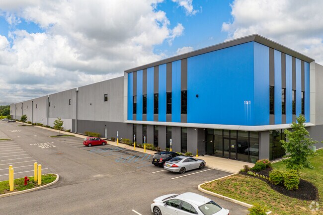
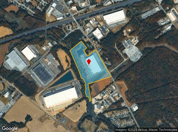
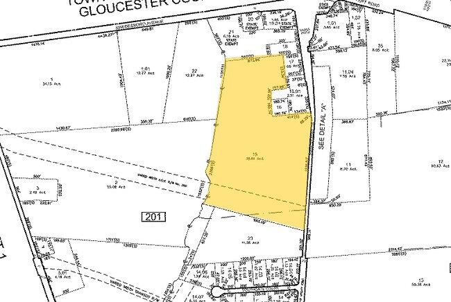
191 Harmony Rd
03-00201-0000-00015-0000-QFARM
Gloucester
Vacantlandnec
New Jersey
AE
15
34015C0067F
38.61 AC
2024
Gloucester County
2025
Philadelphia
500601
Philadelphia-Camden-Wilmington, PA-NJ-DE-MD
DEMOGRAPHICS near 191 Harmony Rd
1 Mile
3 Mile
5 Mile
2024 Total Population
1,921
21,206
58,516
2029 Population
1,980
21,927
60,240
Pop Growth 2024-2029
+ 3.07%
+ 3.40%
+ 2.95%
Average Age
44
40
41
2024 Total Households
780
7,904
22,431
HH Growth 2024-2029
+ 3.08%
+ 3.49%
+ 3.00%
Median Household Inc
$90,493
$87,397
$93,422
Avg Household Size
2.50
2.60
2.60
2024 Avg HH Vehicles
2.00
2.00
2.00
Median Home Value
$252,338
$281,779
$282,280
Median Year Built
1970
1967
1976
Nearby Places
Map Layers
Map Styles
 Street
 Aerial
- Restaurants
- Banks
- Shops
- Fitness
- Groceries
PUBLIC TRANSPORTATION
AIRPORT
Philadelphia International
DRIVE
WALK
Distance
Philadelphia International
29 min
17.7 mi
Freight Ports
Broadway Terminal - Pier 5
DRIVE
WALK
Distance
Broadway Terminal - Pier 5
18 min
11.8 mi
SALE & LEASE HISTORY
LISTING DATE
SALE/LEASE

Oct 14, 2022
For Lease
May 29, 2019
For Lease
Jul 31, 2022
For Lease
Jul 29, 2022
For Lease
Jan 30, 2023
For Lease
Aug 03, 2020
For Sale
Nearby Properties
Address
Land Use
TOTAL SIZE
Lot Size
Zoning
Address
Land Use
TOTAL SIZE
Lot Size
Zoning
653.90 AC
Address
Land Use
TOTAL SIZE
Lot Size
Zoning
69.05 AC
M2
Address
Land Use
TOTAL SIZE
Lot Size
Zoning
71.49 AC
Address
Land Use
TOTAL SIZE
Lot Size
Zoning
28 AC
IC
Address
Land Use
TOTAL SIZE
Lot Size
Zoning
47.40 AC
C2
Address
Land Use
TOTAL SIZE
Lot Size
Zoning
Address
Land Use
TOTAL SIZE
Lot Size
Zoning
40.25 AC
M
Address
Land Use
TOTAL SIZE
Lot Size
Zoning
34.58 AC
Address
Land Use
TOTAL SIZE
Lot Size
Zoning
32.88 AC
M1
Address
Land Use
TOTAL SIZE
Lot Size
Zoning
Address
Land Use
TOTAL SIZE
Lot Size
Zoning
Address
Land Use
TOTAL SIZE
Lot Size
Zoning
Address
Land Use
TOTAL SIZE
Lot Size
Zoning
24.27 AC
M2
Address
Land Use
TOTAL SIZE
Lot Size
Zoning
994 AC
R3
Address
Land Use
TOTAL SIZE
Lot Size
Zoning
55.38 AC
M2
Address
Land Use
TOTAL SIZE
Lot Size
Zoning
111.40 AC
RRC
Address
Land Use
TOTAL SIZE
Lot Size
Zoning
36.52 AC
M1
Address
Land Use
TOTAL SIZE
Lot Size
Zoning
31 AC
M1
Address
Land Use
TOTAL SIZE
Lot Size
Zoning
27.18 AC
M1
Address
Land Use
TOTAL SIZE
Lot Size
Zoning
30.76 AC
BP
Address
Land Use
TOTAL SIZE
Lot Size
Zoning
10.13 AC
Address
Land Use
TOTAL SIZE
Lot Size
Zoning
5.72 AC
R3
Address
Land Use
TOTAL SIZE
Lot Size
Zoning
5 AC
R1
Address
Land Use
TOTAL SIZE
Lot Size
Zoning
10.39 AC
RRC
Address
Land Use
TOTAL SIZE
Lot Size
Zoning
14.66 AC
M1
Address
Land Use
TOTAL SIZE
Lot Size
Zoning
18.21 AC
M1
Address
Land Use
TOTAL SIZE
Lot Size
Zoning
14.91 AC
M1
Address
Land Use
TOTAL SIZE
Lot Size
Zoning
4.76 AC
Address
Land Use
TOTAL SIZE
Lot Size
Zoning
17.42 AC
M2
Address
Land Use
TOTAL SIZE
Lot Size
Zoning
10.21 AC
RRC
The World's #1 Commercial Real Estate Marketplace
Connect with us
© 2025 CoStar Group
The information above has been obtained from sources believed reliable. While we do not doubt its accuracy we have not verified it and make no guarantee, warranty or representation about it. It is your responsibility to independently confirm its accuracy and completeness. Any projections, opinions, assumptions, or estimates used are for example only and do not represent the current or future performance of the property. The value of this transaction to you depends on tax and other factors which should be evaluated by your tax, financial, and legal advisors. You and your advisors should conduct a careful, independent investigation of the property to determine to your satisfaction the suitability of the property for your needs.