Property Record
191 Private Rd, Carthage, TX 75633
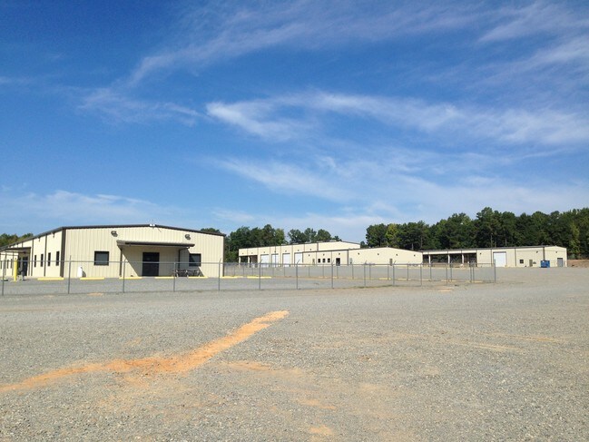
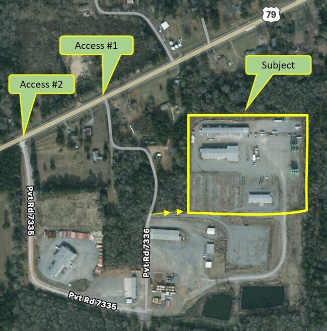
Property Detail
191 Private Rd
21233
AB 24 B ANDERSON
Commercialnec
PANOLA
85
Texas
2025
24.42 AC
2025
Texas East Area
950401
Other Market Areas
32,400 SF
NEARBY LISTINGS FOR SALE OR LEASE
-
-
View all Carthage listings for lease on LoopNet.com
DEMOGRAPHICS near 191 Private Rd
1 mile
3 mile
5 mile
2025 Total Population
218
1,428
3,166
2030 Population
221
1,427
3,174
Pop Growth 2025-2030
+ 1.38%
(0.07%)
+ 0.25%
Average Age
44
44
44
2025 Total Households
93
581
1,264
HH Growth 2025-2030
+ 1.08%
(0.17%)
+ 0.16%
Median Household Inc
$52,608
$52,500
$53,021
Avg Household Size
2.30
2.40
2.40
2025 Avg HH Vehicles
1.00
2.00
2.00
Median Home Value
$133,333
$186,956
$180,302
Median Year Built
1982
1987
1991
Nearby Places
Map Layers
Map Styles
 Street
 Aerial
Transit
 Traffic
 Biking
Places
Listings with unknown addresses are not visible on the map
- Restaurants
- Banks
- Shops
- Fitness
- Groceries
PUBLIC TRANSPORTATION
AIRPORT
Shreveport Regional
Drive
Walk
Distance
Shreveport Regional
30 min
20.2 mi
Freight Ports
Port of Shreveport
Drive
Walk
Distance
Port of Shreveport
42 min
33.1 mi
SALE & LEASE HISTORY
LISTING DATE
SALE/LEASE

Mar 24, 2017
For Lease
Mar 09, 2017
For Lease
Nearby Properties
Address
Land Use
TOTAL SIZE
Lot Size
Zoning
Address
Land Use
TOTAL SIZE
Lot Size
Zoning
134.10 AC
Address
Land Use
TOTAL SIZE
Lot Size
Zoning
8,000 SF
0.97 AC
Address
Land Use
TOTAL SIZE
Lot Size
Zoning
160.55 AC
Address
Land Use
TOTAL SIZE
Lot Size
Zoning
16,000 SF
11.81 AC
03
Address
Land Use
TOTAL SIZE
Lot Size
Zoning
100 SF
20.13 AC
Address
Land Use
TOTAL SIZE
Lot Size
Zoning
97.14 AC
Address
Land Use
TOTAL SIZE
Lot Size
Zoning
2,353 SF
1 AC
Address
Land Use
TOTAL SIZE
Lot Size
Zoning
87.71 AC
Address
Land Use
TOTAL SIZE
Lot Size
Zoning
89.77 AC
Address
Land Use
TOTAL SIZE
Lot Size
Zoning
106 AC
Address
Land Use
TOTAL SIZE
Lot Size
Zoning
77.10 AC
Address
Land Use
TOTAL SIZE
Lot Size
Zoning
100 SF
1 AC
Address
Land Use
TOTAL SIZE
Lot Size
Zoning
1,800 SF
43.43 AC
Address
Land Use
TOTAL SIZE
Lot Size
Zoning
133.40 AC
Address
Land Use
TOTAL SIZE
Lot Size
Zoning
59.25 AC
Address
Land Use
TOTAL SIZE
Lot Size
Zoning
2,036 SF
1 AC
Address
Land Use
TOTAL SIZE
Lot Size
Zoning
1,092 SF
1 AC
98
Address
Land Use
TOTAL SIZE
Lot Size
Zoning
56.50 AC
Address
Land Use
TOTAL SIZE
Lot Size
Zoning
20.96 AC
97
Address
Land Use
TOTAL SIZE
Lot Size
Zoning
53 AC
Address
Land Use
TOTAL SIZE
Lot Size
Zoning
100 SF
19.37 AC
Address
Land Use
TOTAL SIZE
Lot Size
Zoning
31 AC
Address
Land Use
TOTAL SIZE
Lot Size
Zoning
29.59 AC
99
Address
Land Use
TOTAL SIZE
Lot Size
Zoning
138.74 AC
93
Address
Land Use
TOTAL SIZE
Lot Size
Zoning
152.60 AC
Address
Land Use
TOTAL SIZE
Lot Size
Zoning
50 AC
Address
Land Use
TOTAL SIZE
Lot Size
Zoning
800 SF
41.19 AC
Address
Land Use
TOTAL SIZE
Lot Size
Zoning
23.21 AC
Address
Land Use
TOTAL SIZE
Lot Size
Zoning
960 SF
19 AC
The World's #1 Commercial Real Estate Marketplace
Connect with us
© 2026 CoStar Group
The information above has been obtained from sources believed reliable. While we do not doubt its accuracy we have not verified it and make no guarantee, warranty or representation about it. It is your responsibility to independently confirm its accuracy and completeness. Any projections, opinions, assumptions, or estimates used are for example only and do not represent the current or future performance of the property. The value of this transaction to you depends on tax and other factors which should be evaluated by your tax, financial, and legal advisors. You and your advisors should conduct a careful, independent investigation of the property to determine to your satisfaction the suitability of the property for your needs.