Property Record
191 Putnam St, Paterson, NJ 07524
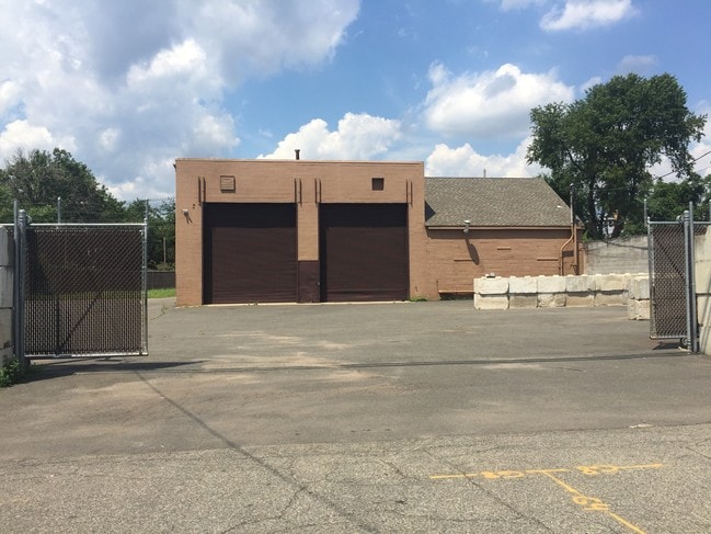

Property Detail
191 Putnam St
New York-Jersey City-White Plains, NY-NJ
Passaic
08-02805-0000-00016
New Jersey
Vacantlandnec
16
B and X Area of moderate flood hazard, usually the area between the limits of the 100-year and 500-year floods.
0.12 AC
2024
Paterson
2025
Northern New Jersey
180800
NEARBY LISTINGS FOR SALE OR LEASE
DEMOGRAPHICS near 191 Putnam St
1 mile
3 mile
5 mile
2025 Total Population
58,417
267,613
537,033
2030 Population
58,742
270,033
544,479
Pop Growth 2025-2030
+ 0.56%
+ 0.90%
+ 1.39%
Average Age
36
39
40
2025 Total Households
18,727
87,902
179,880
HH Growth 2025-2030
+ 0.42%
+ 0.98%
+ 1.42%
Median Household Inc
$48,959
$74,838
$87,897
Avg Household Size
3.00
2.90
2.90
2025 Avg HH Vehicles
1.00
1.00
2.00
Median Home Value
$366,792
$469,012
$539,029
Median Year Built
1950
1953
1954
Nearby Places
Map Layers
Map Styles
 Street
 Aerial
Transit
 Traffic
 Biking
Places
Listings with unknown addresses are not visible on the map
- Restaurants
- Banks
- Shops
- Fitness
- Groceries
PUBLIC TRANSPORTATION
COMMUTER RAIL
Paterson (Main/Port Jervis Line - NJ Transit Commuter Rail (NJ Transit))
Drive
Walk
Distance
Paterson (Main/Port Jervis Line - NJ Transit Commuter Rail (NJ Transit))
4 min
1.8 mi
Hawthorne (Main/Port Jervis Line - NJ Transit Commuter Rail (NJ Transit))
Drive
Walk
Distance
Hawthorne (Main/Port Jervis Line - NJ Transit Commuter Rail (NJ Transit))
5 min
1.9 mi
AIRPORT
Newark Liberty International
Drive
Walk
Distance
Newark Liberty International
28 min
21.9 mi
LaGuardia
Drive
Walk
Distance
LaGuardia
39 min
24.2 mi
Westchester County
Drive
Walk
Distance
Westchester County
59 min
40.0 mi
Freight Ports
Maher Terminal
Drive
Walk
Distance
Maher Terminal
33 min
21.6 mi
SALE & LEASE HISTORY
LISTING DATE
SALE/LEASE

Sep 25, 2016
For Lease
Nearby Properties
Address
Land Use
TOTAL SIZE
Lot Size
Zoning
Address
Land Use
TOTAL SIZE
Lot Size
Zoning
8.75 AC
Address
Land Use
TOTAL SIZE
Lot Size
Zoning
12,506 SF
130 AC
B-2
Address
Land Use
TOTAL SIZE
Lot Size
Zoning
45,000 SF
124.04 AC
R-A
Address
Land Use
TOTAL SIZE
Lot Size
Zoning
79,310 SF
2 AC
B-2
Address
Land Use
TOTAL SIZE
Lot Size
Zoning
26,816 SF
25.50 AC
POP
Address
Land Use
TOTAL SIZE
Lot Size
Zoning
9.96 AC
MU
Address
Land Use
TOTAL SIZE
Lot Size
Zoning
152,050 SF
1.96 AC
B-1
Address
Land Use
TOTAL SIZE
Lot Size
Zoning
57,680 SF
20.01 AC
CR
Address
Land Use
TOTAL SIZE
Lot Size
Zoning
84.08 AC
Address
Land Use
TOTAL SIZE
Lot Size
Zoning
7.83 AC
Address
Land Use
TOTAL SIZE
Lot Size
Zoning
1.80 AC
Address
Land Use
TOTAL SIZE
Lot Size
Zoning
0.69 AC
I-1
Address
Land Use
TOTAL SIZE
Lot Size
Zoning
19.20 AC
Address
Land Use
TOTAL SIZE
Lot Size
Zoning
824,024 SF
39.71 AC
I1
Address
Land Use
TOTAL SIZE
Lot Size
Zoning
1,512 SF
90 AC
Address
Land Use
TOTAL SIZE
Lot Size
Zoning
90.48 AC
Address
Land Use
TOTAL SIZE
Lot Size
Zoning
Address
Land Use
TOTAL SIZE
Lot Size
Zoning
5.88 AC
Address
Land Use
TOTAL SIZE
Lot Size
Zoning
1,482 SF
55.66 AC
R-B
Address
Land Use
TOTAL SIZE
Lot Size
Zoning
27.25 AC
Address
Land Use
TOTAL SIZE
Lot Size
Zoning
764,364 SF
16.60 AC
I-2
Address
Land Use
TOTAL SIZE
Lot Size
Zoning
11.87 AC
Address
Land Use
TOTAL SIZE
Lot Size
Zoning
0.12 AC
Address
Land Use
TOTAL SIZE
Lot Size
Zoning
Address
Land Use
TOTAL SIZE
Lot Size
Zoning
220,994 SF
16.48 AC
Address
Land Use
TOTAL SIZE
Lot Size
Zoning
183,072 SF
5.50 AC
Address
Land Use
TOTAL SIZE
Lot Size
Zoning
192,252 SF
5 AC
Address
Land Use
TOTAL SIZE
Lot Size
Zoning
269,236 SF
10 AC
Address
Land Use
TOTAL SIZE
Lot Size
Zoning
140,626 SF
3.28 AC
B-2
Address
Land Use
TOTAL SIZE
Lot Size
Zoning
91,212 SF
9.52 AC
R-03
The World's #1 Commercial Real Estate Marketplace
Connect with us
© 2026 CoStar Group
The information above has been obtained from sources believed reliable. While we do not doubt its accuracy we have not verified it and make no guarantee, warranty or representation about it. It is your responsibility to independently confirm its accuracy and completeness. Any projections, opinions, assumptions, or estimates used are for example only and do not represent the current or future performance of the property. The value of this transaction to you depends on tax and other factors which should be evaluated by your tax, financial, and legal advisors. You and your advisors should conduct a careful, independent investigation of the property to determine to your satisfaction the suitability of the property for your needs.