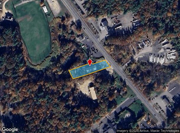
Property Record
191 Rockingham Rd, Derry, NH 03038

NEARBY LISTINGS FOR SALE OR LEASE
Property Detail
191 Rockingham Rd
Vehiclerentalsvehiclesales
Rockingham
X
New Hampshire
33015C0531E
0.65 AC
2024
Rockingham
2024
Boston
003601
Boston-Cambridge-Newton, MA-NH
4,000 SF
DERY-000003-000000-000084
DEMOGRAPHICS near 191 Rockingham Rd
1 mile
3 mile
5 mile
2024 Total Population
2,230
25,516
61,492
2029 Population
2,273
26,310
63,684
Pop Growth 2024-2029
+ 1.93%
+ 3.11%
+ 3.56%
Average Age
41
41
42
2024 Total Households
801
9,831
23,332
HH Growth 2024-2029
+ 1.62%
+ 3.01%
+ 3.47%
Median Household Inc
$118,859
$98,443
$108,462
Avg Household Size
2.70
2.50
2.60
2024 Avg HH Vehicles
3.00
2.00
2.00
Median Home Value
$361,312
$370,306
$411,469
Median Year Built
1981
1981
1981
Nearby Places
Map Layers
Map Styles
 Street
 Aerial
Transit
 Traffic
 Biking
Places
Listings with unknown addresses are not visible on the map
- Restaurants
- Banks
- Shops
- Fitness
- Groceries
PUBLIC TRANSPORTATION
AIRPORT
Manchester Boston Regional
Drive
Walk
Distance
Manchester Boston Regional
29 min
12.5 mi
General Edward Lawrence Logan International
Drive
Walk
Distance
General Edward Lawrence Logan International
57 min
41.3 mi
Portsmouth International at Pease
Drive
Walk
Distance
Portsmouth International at Pease
65 min
44.9 mi
Freight Ports
Port of Boston
Drive
Walk
Distance
Port of Boston
58 min
41.0 mi
SALE & LEASE HISTORY
LISTING DATE
SALE/LEASE

Aug 23, 2023
For Lease
Nearby Properties
Address
Land Use
TOTAL SIZE
Lot Size
Zoning
Address
Land Use
TOTAL SIZE
Lot Size
Zoning
54.56 AC
MFR
Address
Land Use
TOTAL SIZE
Lot Size
Zoning
146,407 SF
15.39 AC
OMB
Address
Land Use
TOTAL SIZE
Lot Size
Zoning
40.50 AC
MDR
Address
Land Use
TOTAL SIZE
Lot Size
Zoning
12.94 AC
MFR
Address
Land Use
TOTAL SIZE
Lot Size
Zoning
166,979 SF
22.08 AC
MHDR
Address
Land Use
TOTAL SIZE
Lot Size
Zoning
108,248 SF
5.92 AC
OMB
Address
Land Use
TOTAL SIZE
Lot Size
Zoning
69,266 SF
6.02 AC
MHDR
Address
Land Use
TOTAL SIZE
Lot Size
Zoning
21.72 AC
LMDR
Address
Land Use
TOTAL SIZE
Lot Size
Zoning
32.45 AC
C-II
Address
Land Use
TOTAL SIZE
Lot Size
Zoning
2.21 AC
GC
Address
Land Use
TOTAL SIZE
Lot Size
Zoning
4.10 AC
MFR
Address
Land Use
TOTAL SIZE
Lot Size
Zoning
4.14 AC
MFR
Address
Land Use
TOTAL SIZE
Lot Size
Zoning
4 AC
MFR
Address
Land Use
TOTAL SIZE
Lot Size
Zoning
54,940 SF
3.78 AC
MHDR
Address
Land Use
TOTAL SIZE
Lot Size
Zoning
145 AC
IND1
Address
Land Use
TOTAL SIZE
Lot Size
Zoning
51,881 SF
12.01 AC
MDR
Address
Land Use
TOTAL SIZE
Lot Size
Zoning
37,931 SF
1.31 AC
CBD
Address
Land Use
TOTAL SIZE
Lot Size
Zoning
Address
Land Use
TOTAL SIZE
Lot Size
Zoning
38,664 SF
4.53 AC
MHDR
Address
Land Use
TOTAL SIZE
Lot Size
Zoning
32,328 SF
2.43 AC
MFR
Address
Land Use
TOTAL SIZE
Lot Size
Zoning
7.21 AC
IND5
Address
Land Use
TOTAL SIZE
Lot Size
Zoning
25,560 SF
2 AC
MHDR
Address
Land Use
TOTAL SIZE
Lot Size
Zoning
25,560 SF
2.40 AC
MHDR
Address
Land Use
TOTAL SIZE
Lot Size
Zoning
31,896 SF
2.50 AC
MFR
Address
Land Use
TOTAL SIZE
Lot Size
Zoning
31,896 SF
1.81 AC
MFR
Address
Land Use
TOTAL SIZE
Lot Size
Zoning
31,896 SF
1.81 AC
MFR
Address
Land Use
TOTAL SIZE
Lot Size
Zoning
60,654 SF
7.03 AC
IND1
Address
Land Use
TOTAL SIZE
Lot Size
Zoning
2.50 AC
MFR
Address
Land Use
TOTAL SIZE
Lot Size
Zoning
21,645 SF
0.85 AC
MHDR
Address
Land Use
TOTAL SIZE
Lot Size
Zoning
936 SF
15.40 AC
MHPD
The World's #1 Commercial Real Estate Marketplace
Connect with us
© 2026 CoStar Group
The information above has been obtained from sources believed reliable. While we do not doubt its accuracy we have not verified it and make no guarantee, warranty or representation about it. It is your responsibility to independently confirm its accuracy and completeness. Any projections, opinions, assumptions, or estimates used are for example only and do not represent the current or future performance of the property. The value of this transaction to you depends on tax and other factors which should be evaluated by your tax, financial, and legal advisors. You and your advisors should conduct a careful, independent investigation of the property to determine to your satisfaction the suitability of the property for your needs.