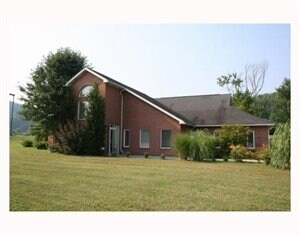
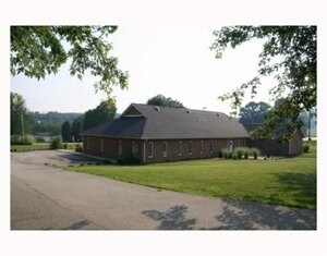
Property Record
191 Shrader Hollow Rd, New Stanton, PA 15672
NEARBY LISTINGS FOR SALE OR LEASE
-
-
View all New Stanton listings for sale on LoopNet.com
Property Detail
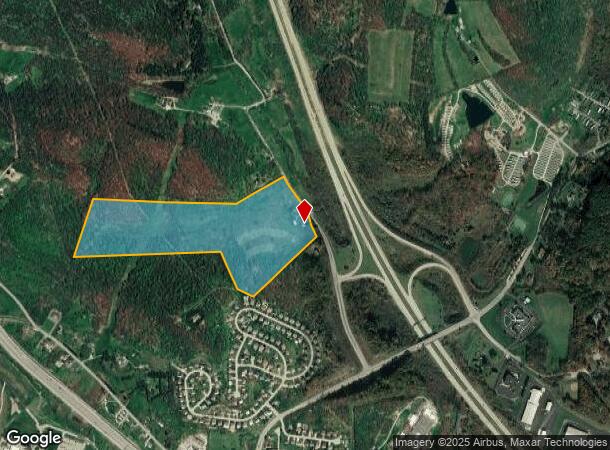
191 Shrader Hollow Rd
64-02-00-0-004
Shaw-Shrader Hollow Plan No 1
Agriculturalnec
HSE BLDGS
X
Westmoreland
42129C0626F
Pennsylvania
2025
50.50 AC
2025
Westmoreland County
804901
Pittsburgh
1,358 SF
Pittsburgh, PA
DEMOGRAPHICS near 191 Shrader Hollow Rd
1 Mile
3 Mile
5 Mile
2024 Total Population
1,039
10,608
31,954
2029 Population
1,020
10,350
31,363
Pop Growth 2024-2029
(1.83%)
(2.43%)
(1.85%)
Average Age
42
45
45
2024 Total Households
429
4,660
13,800
HH Growth 2024-2029
(1.86%)
(2.51%)
(1.96%)
Median Household Inc
$89,749
$72,333
$63,038
Avg Household Size
2.40
2.20
2.20
2024 Avg HH Vehicles
2.00
2.00
2.00
Median Home Value
$226,923
$175,994
$175,237
Median Year Built
1974
1969
1970
Nearby Places
Map Layers
Map Styles
 Street
 Aerial
- Restaurants
- Banks
- Shops
- Fitness
- Groceries
PUBLIC TRANSPORTATION
COMMUTER RAIL
Greensburg Amtrak (Pennsylvanian - Amtrak)
DRIVE
WALK
Distance
Greensburg Amtrak (Pennsylvanian - Amtrak)
13 min
7.6 mi
AIRPORT
Arnold Palmer Regional
DRIVE
WALK
Distance
Arnold Palmer Regional
29 min
17.0 mi
Freight Ports
Port of Baltimore
DRIVE
WALK
Distance
Port of Baltimore
253 min
216.9 mi
Nearby Properties
Address
Land Use
TOTAL SIZE
Lot Size
Zoning
Address
Land Use
TOTAL SIZE
Lot Size
Zoning
37.67 AC
Address
Land Use
TOTAL SIZE
Lot Size
Zoning
21.91 AC
Address
Land Use
TOTAL SIZE
Lot Size
Zoning
32.50 AC
Address
Land Use
TOTAL SIZE
Lot Size
Zoning
Address
Land Use
TOTAL SIZE
Lot Size
Zoning
14.79 AC
Address
Land Use
TOTAL SIZE
Lot Size
Zoning
13.39 AC
Address
Land Use
TOTAL SIZE
Lot Size
Zoning
35.40 AC
Address
Land Use
TOTAL SIZE
Lot Size
Zoning
57.96 AC
Address
Land Use
TOTAL SIZE
Lot Size
Zoning
Address
Land Use
TOTAL SIZE
Lot Size
Zoning
57.80 AC
Address
Land Use
TOTAL SIZE
Lot Size
Zoning
Address
Land Use
TOTAL SIZE
Lot Size
Zoning
9.23 AC
Address
Land Use
TOTAL SIZE
Lot Size
Zoning
Address
Land Use
TOTAL SIZE
Lot Size
Zoning
Address
Land Use
TOTAL SIZE
Lot Size
Zoning
1,924 SF
6.55 AC
Address
Land Use
TOTAL SIZE
Lot Size
Zoning
11.95 AC
Address
Land Use
TOTAL SIZE
Lot Size
Zoning
90,464 SF
21 AC
Address
Land Use
TOTAL SIZE
Lot Size
Zoning
141.89 AC
Address
Land Use
TOTAL SIZE
Lot Size
Zoning
11.28 AC
Address
Land Use
TOTAL SIZE
Lot Size
Zoning
82,116 SF
22.17 AC
Address
Land Use
TOTAL SIZE
Lot Size
Zoning
5.20 AC
Address
Land Use
TOTAL SIZE
Lot Size
Zoning
33,696 SF
2 AC
Address
Land Use
TOTAL SIZE
Lot Size
Zoning
4.60 AC
Address
Land Use
TOTAL SIZE
Lot Size
Zoning
50,330 SF
12.65 AC
Address
Land Use
TOTAL SIZE
Lot Size
Zoning
300.50 AC
Address
Land Use
TOTAL SIZE
Lot Size
Zoning
26.05 AC
Address
Land Use
TOTAL SIZE
Lot Size
Zoning
31,210 SF
4.93 AC
Address
Land Use
TOTAL SIZE
Lot Size
Zoning
30.30 AC
Address
Land Use
TOTAL SIZE
Lot Size
Zoning
44,216 SF
16 AC
Address
Land Use
TOTAL SIZE
Lot Size
Zoning
18.88 AC
The World's #1 Commercial Real Estate Marketplace
Connect with us
© 2025 CoStar Group
The information above has been obtained from sources believed reliable. While we do not doubt its accuracy we have not verified it and make no guarantee, warranty or representation about it. It is your responsibility to independently confirm its accuracy and completeness. Any projections, opinions, assumptions, or estimates used are for example only and do not represent the current or future performance of the property. The value of this transaction to you depends on tax and other factors which should be evaluated by your tax, financial, and legal advisors. You and your advisors should conduct a careful, independent investigation of the property to determine to your satisfaction the suitability of the property for your needs.