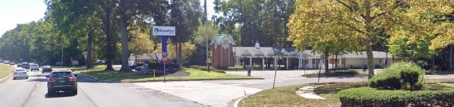
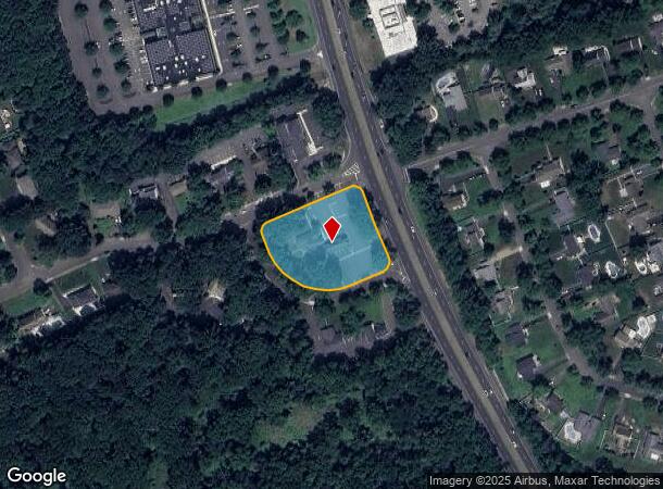
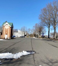
Property Record
191 Us Highway 9, Manalapan, NJ 07726
Current Lease Availabilities
NEARBY LISTINGS FOR SALE OR LEASE
Property Detail
191 Us Highway 9
New York-Jersey City-White Plains, NY-NJ
Monmouth Village Sec 01
28-01802-0000-00001
COMMUNITY BANK
Financialbuilding
Monmouth
X
New Jersey
34025C0141F
1
2024
1.78 AC
2025
Western Monmouth
810102
Northern New Jersey
DEMOGRAPHICS near 191 Us Highway 9
1 Mile
3 Mile
5 Mile
2024 Total Population
5,723
51,593
114,362
2029 Population
5,664
50,906
113,217
Pop Growth 2024-2029
(1.03%)
(1.33%)
(1.00%)
Average Age
42
43
43
2024 Total Households
1,875
17,610
39,803
HH Growth 2024-2029
(1.33%)
(1.39%)
(1.10%)
Median Household Inc
$170,352
$134,942
$133,591
Avg Household Size
3.00
2.80
2.80
2024 Avg HH Vehicles
2.00
2.00
2.00
Median Home Value
$525,549
$582,205
$576,381
Median Year Built
1981
1980
1984
Nearby Places
- Restaurants
- Banks
- Shops
- Fitness
- Groceries
PUBLIC TRANSPORTATION
AIRPORT
Newark Liberty International
DRIVE
WALK
Distance
Newark Liberty International
52 min
34.9 mi
Trenton Mercer
DRIVE
WALK
Distance
Trenton Mercer
56 min
35.9 mi
Freight Ports
New York Container Terminal
DRIVE
WALK
Distance
New York Container Terminal
40 min
30.4 mi
Nearby Properties
Address
Land Use
TOTAL SIZE
Lot Size
Zoning
Address
Land Use
TOTAL SIZE
Lot Size
Zoning
56.99 AC
C1
Address
Land Use
TOTAL SIZE
Lot Size
Zoning
25.27 AC
C1
Address
Land Use
TOTAL SIZE
Lot Size
Zoning
278,199 SF
6.92 AC
R-10
Address
Land Use
TOTAL SIZE
Lot Size
Zoning
138.38 AC
R-E
Address
Land Use
TOTAL SIZE
Lot Size
Zoning
21 AC
R-40
Address
Land Use
TOTAL SIZE
Lot Size
Zoning
48,451 SF
12.17 AC
B-10
Address
Land Use
TOTAL SIZE
Lot Size
Zoning
23.08 AC
PB
Address
Land Use
TOTAL SIZE
Lot Size
Zoning
200,294 SF
12 AC
R10
Address
Land Use
TOTAL SIZE
Lot Size
Zoning
54,065 SF
19.07 AC
CM3A
Address
Land Use
TOTAL SIZE
Lot Size
Zoning
6.97 AC
C2
Address
Land Use
TOTAL SIZE
Lot Size
Zoning
1,800 SF
83.93 AC
R120
Address
Land Use
TOTAL SIZE
Lot Size
Zoning
189,210 SF
8.07 AC
0
Address
Land Use
TOTAL SIZE
Lot Size
Zoning
8.32 AC
R-40
Address
Land Use
TOTAL SIZE
Lot Size
Zoning
8.15 AC
C2-M
Address
Land Use
TOTAL SIZE
Lot Size
Zoning
27,535 SF
7.03 AC
CM3A
Address
Land Use
TOTAL SIZE
Lot Size
Zoning
16,496 SF
10.87 AC
CM3A
Address
Land Use
TOTAL SIZE
Lot Size
Zoning
36,284 SF
8.31 AC
CM3A
Address
Land Use
TOTAL SIZE
Lot Size
Zoning
28,383 SF
20.77 AC
B10
Address
Land Use
TOTAL SIZE
Lot Size
Zoning
10.25 AC
PB
Address
Land Use
TOTAL SIZE
Lot Size
Zoning
58,674 SF
44 SF
C-3
Address
Land Use
TOTAL SIZE
Lot Size
Zoning
58,024 SF
9.45 AC
C2
Address
Land Use
TOTAL SIZE
Lot Size
Zoning
14,192 SF
6.35 AC
CM3A
Address
Land Use
TOTAL SIZE
Lot Size
Zoning
98,000 SF
7.52 AC
7663
Address
Land Use
TOTAL SIZE
Lot Size
Zoning
7,356 SF
43.47 AC
R-E
Address
Land Use
TOTAL SIZE
Lot Size
Zoning
65,708 SF
13.65 AC
C-5
Address
Land Use
TOTAL SIZE
Lot Size
Zoning
17,342 SF
64.55 AC
ROS
Address
Land Use
TOTAL SIZE
Lot Size
Zoning
2,322 SF
44.35 AC
R-E
Address
Land Use
TOTAL SIZE
Lot Size
Zoning
84,626 SF
15.37 AC
R120
Address
Land Use
TOTAL SIZE
Lot Size
Zoning
41,632 SF
6.26 AC
OB01
Address
Land Use
TOTAL SIZE
Lot Size
Zoning
6.37 AC
C2
The World's #1 Commercial Real Estate Marketplace
Connect with us
© 2025 CoStar Group
The information above has been obtained from sources believed reliable. While we do not doubt its accuracy we have not verified it and make no guarantee, warranty or representation about it. It is your responsibility to independently confirm its accuracy and completeness. Any projections, opinions, assumptions, or estimates used are for example only and do not represent the current or future performance of the property. The value of this transaction to you depends on tax and other factors which should be evaluated by your tax, financial, and legal advisors. You and your advisors should conduct a careful, independent investigation of the property to determine to your satisfaction the suitability of the property for your needs.