Property Record
1910 Byrd Ave, Richmond, VA 23230

Current Lease Availabilities
NEARBY LISTINGS FOR SALE OR LEASE
Property Detail
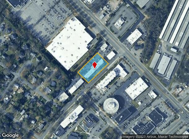
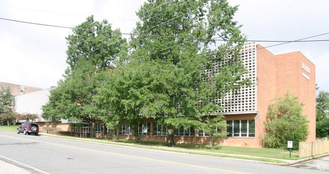
1910 Byrd Ave
Richmond, VA
Shenandoah Place
772-738-6931
0103090000I 0031; SHENANDOAH PLACE BL I LT 31 TO 37 PT ALLEY95A A2 3
Officebuilding
Henrico
X
Virginia
5101290028E
31-37
2025
1 AC
2025
West End
200301
Richmond VA
24,359 SF
DEMOGRAPHICS near 1910 Byrd Ave
1 Mile
3 Mile
5 Mile
2024 Total Population
9,561
92,135
253,094
2029 Population
9,789
93,514
257,081
Pop Growth 2024-2029
+ 2.38%
+ 1.50%
+ 1.58%
Average Age
41
40
39
2024 Total Households
4,493
42,600
111,911
HH Growth 2024-2029
+ 2.56%
+ 1.67%
+ 1.65%
Median Household Inc
$91,477
$79,502
$66,573
Avg Household Size
2.10
2.00
2.10
2024 Avg HH Vehicles
2.00
2.00
2.00
Median Home Value
$399,054
$372,809
$318,286
Median Year Built
1957
1955
1963
Nearby Places
- Restaurants
- Banks
- Shops
- Fitness
- Groceries
PUBLIC TRANSPORTATION
COMMUTER RAIL
DRIVE
WALK
Distance
7 min
3.2 mi
DRIVE
WALK
Distance
12 min
7.8 mi
AIRPORT
Richmond International
DRIVE
WALK
Distance
Richmond International
25 min
15.7 mi
Freight Ports
Virginia Port Authority - Richmond
DRIVE
WALK
Distance
Virginia Port Authority - Richmond
21 min
12.7 mi
Nearby Properties
Address
Land Use
TOTAL SIZE
Lot Size
Zoning
Address
Land Use
TOTAL SIZE
Lot Size
Zoning
494,791 SF
38.85 AC
R-6
Address
Land Use
TOTAL SIZE
Lot Size
Zoning
272,131 SF
11.22 AC
R-6 SINGLE
Address
Land Use
TOTAL SIZE
Lot Size
Zoning
597,042 SF
41.03 AC
R-6C
Address
Land Use
TOTAL SIZE
Lot Size
Zoning
482,958 SF
2.38 AC
M-1 LIGHT
Address
Land Use
TOTAL SIZE
Lot Size
Zoning
1,185 SF
2.54 AC
M-1 LIGHT
Address
Land Use
TOTAL SIZE
Lot Size
Zoning
382,570 SF
2.98 AC
UMUC
Address
Land Use
TOTAL SIZE
Lot Size
Zoning
568,334 SF
26.13 AC
MIXE
Address
Land Use
TOTAL SIZE
Lot Size
Zoning
14.89 AC
R-53 MULTI
Address
Land Use
TOTAL SIZE
Lot Size
Zoning
185,604 SF
2.30 AC
MULTIPLE Z
Address
Land Use
TOTAL SIZE
Lot Size
Zoning
16.14 AC
MULTIPLE Z
Address
Land Use
TOTAL SIZE
Lot Size
Zoning
321,552 SF
UMUC
Address
Land Use
TOTAL SIZE
Lot Size
Zoning
2.11 AC
M-1
Address
Land Use
TOTAL SIZE
Lot Size
Zoning
299,820 SF
3.16 AC
M-2 HEAVY
Address
Land Use
TOTAL SIZE
Lot Size
Zoning
319,512 SF
20.33 AC
UMU
Address
Land Use
TOTAL SIZE
Lot Size
Zoning
344,965 SF
28.33 AC
MIXE
Address
Land Use
TOTAL SIZE
Lot Size
Zoning
250,000 SF
4.04 AC
Address
Land Use
TOTAL SIZE
Lot Size
Zoning
97,713 SF
21.60 AC
B-4 CENTRA
Address
Land Use
TOTAL SIZE
Lot Size
Zoning
2,909 SF
2.47 AC
M-1 LIGHT
Address
Land Use
TOTAL SIZE
Lot Size
Zoning
21,954 SF
4.79 AC
B-3 GENERA
Address
Land Use
TOTAL SIZE
Lot Size
Zoning
1,404 SF
30.52 AC
R-5
Address
Land Use
TOTAL SIZE
Lot Size
Zoning
3.25 AC
M-1 LIGHT
Address
Land Use
TOTAL SIZE
Lot Size
Zoning
395,435 SF
13.26 AC
O-3C
Address
Land Use
TOTAL SIZE
Lot Size
Zoning
224,768 SF
18.08 AC
R-6
Address
Land Use
TOTAL SIZE
Lot Size
Zoning
126,303 SF
4.50 AC
M-1 LIGHT
Address
Land Use
TOTAL SIZE
Lot Size
Zoning
182,188 SF
21.84 AC
R-5
Address
Land Use
TOTAL SIZE
Lot Size
Zoning
224,108 SF
2.10 AC
M-2 HEAVY
Address
Land Use
TOTAL SIZE
Lot Size
Zoning
257,130 SF
33.65 AC
B-3
Address
Land Use
TOTAL SIZE
Lot Size
Zoning
227,000 SF
6.32 AC
R-6 SINGLE
Address
Land Use
TOTAL SIZE
Lot Size
Zoning
320,000 SF
0.61 AC
I INSTITUT
Address
Land Use
TOTAL SIZE
Lot Size
Zoning
147,352 SF
8.33 AC
R-5 SINGLE
The World's #1 Commercial Real Estate Marketplace
Connect with us
© 2025 CoStar Group
The information above has been obtained from sources believed reliable. While we do not doubt its accuracy we have not verified it and make no guarantee, warranty or representation about it. It is your responsibility to independently confirm its accuracy and completeness. Any projections, opinions, assumptions, or estimates used are for example only and do not represent the current or future performance of the property. The value of this transaction to you depends on tax and other factors which should be evaluated by your tax, financial, and legal advisors. You and your advisors should conduct a careful, independent investigation of the property to determine to your satisfaction the suitability of the property for your needs.