Property Record
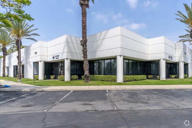
1910 S Archibald Ave, Ontario, CA 91761


Current Lease Availabilities
NEARBY LISTINGS FOR SALE OR LEASE
Property Detail
1910 S Archibald Ave
Riverside-San Bernardino-Ontario, CA
Parcel Map No 11850
0211-371-01
PARCEL MAP 11850 PARCEL 1 UNIT 28 BOOK 138 PAGE 48 AND INTEREST IN COMMON AREA AS DESCRIBED IN CONDO PLAN 2018-0476566
Industrialcondominium
San Bernardino
X
California
06071C8637J
0.06 AC
2024
Airport Area
2025
Inland Empire (California)
001803
DEMOGRAPHICS near 1910 S Archibald Ave
1 Mile
3 Mile
5 Mile
2024 Total Population
2,169
76,741
279,995
2029 Population
2,197
78,457
286,788
Pop Growth 2024-2029
+ 1.29%
+ 2.24%
+ 2.43%
Average Age
38
36
36
2024 Total Households
619
23,258
83,878
HH Growth 2024-2029
+ 1.29%
+ 2.27%
+ 2.41%
Median Household Inc
$90,217
$86,092
$85,256
Avg Household Size
3.50
3.20
3.20
2024 Avg HH Vehicles
3.00
2.00
2.00
Median Home Value
$487,149
$538,283
$570,453
Median Year Built
1977
1987
1984
Nearby Places
Map Layers
Map Styles
 Street
 Aerial
- Restaurants
- Banks
- Shops
- Fitness
- Groceries
PUBLIC TRANSPORTATION
COMMUTER RAIL
East Ontario (Riverside Line - Southern California Regional Rail Authority (Metrolink))
DRIVE
WALK
Distance
East Ontario (Riverside Line - Southern California Regional Rail Authority (Metrolink))
5 min
2.1 mi
DRIVE
WALK
Distance
8 min
4.7 mi
AIRPORT
Ontario International
DRIVE
WALK
Distance
Ontario International
10 min
4.6 mi
John Wayne/Orange County
DRIVE
WALK
Distance
John Wayne/Orange County
48 min
41.0 mi
Freight Ports
Port of Long Beach
DRIVE
WALK
Distance
Port of Long Beach
64 min
50.0 mi
Nearby Properties
Address
Land Use
TOTAL SIZE
Lot Size
Zoning
Address
Land Use
TOTAL SIZE
Lot Size
Zoning
1,281,803 SF
27.85 AC
Address
Land Use
TOTAL SIZE
Lot Size
Zoning
244,370 SF
59.72 AC
Address
Land Use
TOTAL SIZE
Lot Size
Zoning
759,260 SF
42.77 AC
Address
Land Use
TOTAL SIZE
Lot Size
Zoning
539,128 SF
10.24 AC
Address
Land Use
TOTAL SIZE
Lot Size
Zoning
336,640 SF
20.87 AC
Address
Land Use
TOTAL SIZE
Lot Size
Zoning
336,640 SF
20.44 AC
R2
Address
Land Use
TOTAL SIZE
Lot Size
Zoning
489,989 SF
24.49 AC
Address
Land Use
TOTAL SIZE
Lot Size
Zoning
545,161 SF
11.10 AC
Address
Land Use
TOTAL SIZE
Lot Size
Zoning
23.37 AC
Address
Land Use
TOTAL SIZE
Lot Size
Zoning
591,495 SF
18.29 AC
Address
Land Use
TOTAL SIZE
Lot Size
Zoning
1,052,840 SF
41.85 AC
Address
Land Use
TOTAL SIZE
Lot Size
Zoning
531,988 SF
9.83 AC
Address
Land Use
TOTAL SIZE
Lot Size
Zoning
901,662 SF
33.87 AC
IP
Address
Land Use
TOTAL SIZE
Lot Size
Zoning
440,209 SF
10.34 AC
Address
Land Use
TOTAL SIZE
Lot Size
Zoning
235,781 SF
10.80 AC
Address
Land Use
TOTAL SIZE
Lot Size
Zoning
317,070 SF
14.26 AC
Address
Land Use
TOTAL SIZE
Lot Size
Zoning
256,308 SF
11.36 AC
Address
Land Use
TOTAL SIZE
Lot Size
Zoning
387,965 SF
10.92 AC
Address
Land Use
TOTAL SIZE
Lot Size
Zoning
817,493 SF
93.45 AC
Address
Land Use
TOTAL SIZE
Lot Size
Zoning
235,119 SF
11 AC
Address
Land Use
TOTAL SIZE
Lot Size
Zoning
797,408 SF
66.66 AC
Address
Land Use
TOTAL SIZE
Lot Size
Zoning
709,814 SF
29.40 AC
Address
Land Use
TOTAL SIZE
Lot Size
Zoning
923,083 SF
48.34 AC
Address
Land Use
TOTAL SIZE
Lot Size
Zoning
252,800 SF
12.90 AC
Address
Land Use
TOTAL SIZE
Lot Size
Zoning
656,040 SF
28.47 AC
Address
Land Use
TOTAL SIZE
Lot Size
Zoning
245,931 SF
10.84 AC
Address
Land Use
TOTAL SIZE
Lot Size
Zoning
151,805 SF
10.59 AC
CM
Address
Land Use
TOTAL SIZE
Lot Size
Zoning
155,076 SF
7.38 AC
Address
Land Use
TOTAL SIZE
Lot Size
Zoning
123,833 SF
11.23 AC
Address
Land Use
TOTAL SIZE
Lot Size
Zoning
174,430 SF
7.47 AC
The World's #1 Commercial Real Estate Marketplace
Connect with us
© 2025 CoStar Group
The information above has been obtained from sources believed reliable. While we do not doubt its accuracy we have not verified it and make no guarantee, warranty or representation about it. It is your responsibility to independently confirm its accuracy and completeness. Any projections, opinions, assumptions, or estimates used are for example only and do not represent the current or future performance of the property. The value of this transaction to you depends on tax and other factors which should be evaluated by your tax, financial, and legal advisors. You and your advisors should conduct a careful, independent investigation of the property to determine to your satisfaction the suitability of the property for your needs.