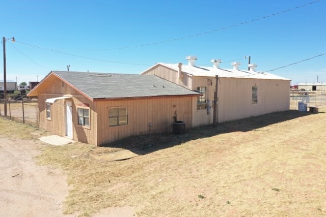
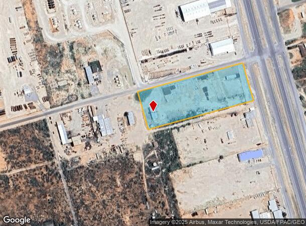
Property Record
1910 N Us Highway 385, Andrews, TX 79714

NEARBY LISTINGS FOR SALE OR LEASE
Property Detail
1910 N Us Highway 385
Andrews, TX
Lonis
000000001474
LONIS TR #4 ALL EXC N50'
Industrialgeneral
Andrews
2025
Texas
2025
4.35 AC
950300
Panhandle Area
4,856 SF
Other Market Areas
DEMOGRAPHICS near 1910 N Us Highway 385
1 Mile
3 Mile
5 Mile
2024 Total Population
494
11,537
17,091
2029 Population
478
11,425
16,885
Pop Growth 2024-2029
(3.24%)
(0.97%)
(1.21%)
Average Age
34
35
35
2024 Total Households
164
3,930
5,761
HH Growth 2024-2029
(3.05%)
(1.02%)
(1.27%)
Median Household Inc
$103,214
$69,779
$77,596
Avg Household Size
3.00
2.90
2.90
2024 Avg HH Vehicles
2.00
2.00
2.00
Median Home Value
$176,999
$153,834
$171,562
Median Year Built
1979
1977
1977
Nearby Places
Map Layers
Map Styles
 Street
 Aerial
- Restaurants
- Banks
- Shops
- Fitness
- Groceries
SALE & LEASE HISTORY
LISTING DATE
SALE/LEASE

Oct 05, 2021
For Sale
Nearby Properties
Address
Land Use
TOTAL SIZE
Lot Size
Zoning
Address
Land Use
TOTAL SIZE
Lot Size
Zoning
98,940 SF
10.08 AC
Address
Land Use
TOTAL SIZE
Lot Size
Zoning
104,148 SF
30.10 AC
Address
Land Use
TOTAL SIZE
Lot Size
Zoning
164,084 SF
5.79 AC
Address
Land Use
TOTAL SIZE
Lot Size
Zoning
317,100 SF
16.23 AC
Address
Land Use
TOTAL SIZE
Lot Size
Zoning
93,100 SF
26.24 AC
Address
Land Use
TOTAL SIZE
Lot Size
Zoning
193,418 SF
292.77 AC
Address
Land Use
TOTAL SIZE
Lot Size
Zoning
46,495 SF
2.43 AC
Address
Land Use
TOTAL SIZE
Lot Size
Zoning
262,632 SF
11.52 AC
Address
Land Use
TOTAL SIZE
Lot Size
Zoning
0.17 AC
Address
Land Use
TOTAL SIZE
Lot Size
Zoning
38,721 SF
1.69 AC
Address
Land Use
TOTAL SIZE
Lot Size
Zoning
67,900 SF
0.97 AC
Address
Land Use
TOTAL SIZE
Lot Size
Zoning
67,275 SF
40.65 AC
Address
Land Use
TOTAL SIZE
Lot Size
Zoning
119,196 SF
8.57 AC
Address
Land Use
TOTAL SIZE
Lot Size
Zoning
48,650 SF
2.07 AC
Address
Land Use
TOTAL SIZE
Lot Size
Zoning
43,530 SF
2 AC
Address
Land Use
TOTAL SIZE
Lot Size
Zoning
22,583 SF
0.96 AC
Address
Land Use
TOTAL SIZE
Lot Size
Zoning
21,110 SF
10.03 AC
Address
Land Use
TOTAL SIZE
Lot Size
Zoning
21,594 SF
3 AC
Address
Land Use
TOTAL SIZE
Lot Size
Zoning
21,716 SF
2.34 AC
Address
Land Use
TOTAL SIZE
Lot Size
Zoning
27,305 SF
0.75 AC
Address
Land Use
TOTAL SIZE
Lot Size
Zoning
28,090 SF
1.98 AC
Address
Land Use
TOTAL SIZE
Lot Size
Zoning
38,268 SF
2.55 AC
Address
Land Use
TOTAL SIZE
Lot Size
Zoning
4,200 SF
0.96 AC
Address
Land Use
TOTAL SIZE
Lot Size
Zoning
111,250 SF
3 AC
Address
Land Use
TOTAL SIZE
Lot Size
Zoning
33,891 SF
2.21 AC
Address
Land Use
TOTAL SIZE
Lot Size
Zoning
20,392 SF
0.68 AC
Address
Land Use
TOTAL SIZE
Lot Size
Zoning
23,013 SF
6.77 AC
Address
Land Use
TOTAL SIZE
Lot Size
Zoning
34,900 SF
5.34 AC
Address
Land Use
TOTAL SIZE
Lot Size
Zoning
19,224 SF
10.21 AC
Address
Land Use
TOTAL SIZE
Lot Size
Zoning
26,250 SF
10.82 AC
The World's #1 Commercial Real Estate Marketplace
Connect with us
© 2025 CoStar Group
The information above has been obtained from sources believed reliable. While we do not doubt its accuracy we have not verified it and make no guarantee, warranty or representation about it. It is your responsibility to independently confirm its accuracy and completeness. Any projections, opinions, assumptions, or estimates used are for example only and do not represent the current or future performance of the property. The value of this transaction to you depends on tax and other factors which should be evaluated by your tax, financial, and legal advisors. You and your advisors should conduct a careful, independent investigation of the property to determine to your satisfaction the suitability of the property for your needs.