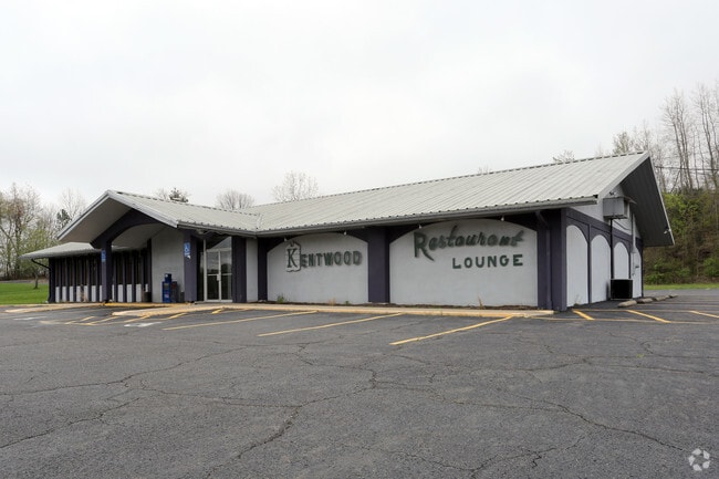
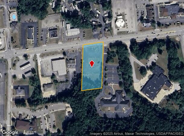
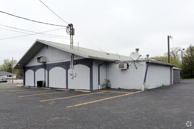
Property Record
1910 State Route 59, Kent, OH 44240
NEARBY LISTINGS FOR SALE OR LEASE
Property Detail
1910 State Route 59
Akron, OH
LOT 21
12-021-00-00-010-000
Portage
Commercialacreage
Ohio
2024
21
2024
2.02 AC
601503
Portage County
5,344 SF
Cleveland
DEMOGRAPHICS near 1910 State Route 59
1 Mile
3 Mile
5 Mile
2024 Total Population
11,182
36,238
75,687
2029 Population
11,240
36,713
76,646
Pop Growth 2024-2029
+ 0.52%
+ 1.31%
+ 1.27%
Average Age
27
35
38
2024 Total Households
3,179
14,479
31,191
HH Growth 2024-2029
+ 1.82%
+ 1.60%
+ 1.38%
Median Household Inc
$21,697
$39,726
$55,579
Avg Household Size
1.90
2.10
2.20
2024 Avg HH Vehicles
1.00
2.00
2.00
Median Home Value
$181,707
$185,722
$188,322
Median Year Built
1977
1973
1974
Nearby Places
- Restaurants
- Banks
- Shops
- Fitness
- Groceries
PUBLIC TRANSPORTATION
AIRPORT
Akron-Canton Regional
DRIVE
WALK
Distance
Akron-Canton Regional
36 min
26.4 mi
Freight Ports
Port of Toledo
DRIVE
WALK
Distance
Port of Toledo
169 min
137.4 mi
SALE & LEASE HISTORY
LISTING DATE
SALE/LEASE

Sep 25, 2016
For Lease
Sep 23, 2016
For Sale
Nearby Properties
Address
Land Use
TOTAL SIZE
Lot Size
Zoning
Address
Land Use
TOTAL SIZE
Lot Size
Zoning
871,059 SF
404.65 AC
Address
Land Use
TOTAL SIZE
Lot Size
Zoning
139,790 SF
102.12 AC
Address
Land Use
TOTAL SIZE
Lot Size
Zoning
183,977 SF
10.12 AC
Address
Land Use
TOTAL SIZE
Lot Size
Zoning
86,411 SF
0.23 AC
Address
Land Use
TOTAL SIZE
Lot Size
Zoning
173,811 SF
9.34 AC
Address
Land Use
TOTAL SIZE
Lot Size
Zoning
61,748 SF
17.12 AC
Address
Land Use
TOTAL SIZE
Lot Size
Zoning
57,455 SF
28.81 AC
Address
Land Use
TOTAL SIZE
Lot Size
Zoning
141,562 SF
1.63 AC
Address
Land Use
TOTAL SIZE
Lot Size
Zoning
150,616 SF
12.63 AC
Address
Land Use
TOTAL SIZE
Lot Size
Zoning
213,347 SF
30.75 AC
Address
Land Use
TOTAL SIZE
Lot Size
Zoning
146,435 SF
59.76 AC
Address
Land Use
TOTAL SIZE
Lot Size
Zoning
179,055 SF
19.68 AC
Address
Land Use
TOTAL SIZE
Lot Size
Zoning
8.12 AC
Address
Land Use
TOTAL SIZE
Lot Size
Zoning
28,438 SF
9 AC
Address
Land Use
TOTAL SIZE
Lot Size
Zoning
310,705 SF
9.96 AC
Address
Land Use
TOTAL SIZE
Lot Size
Zoning
216,994 SF
10.94 AC
Address
Land Use
TOTAL SIZE
Lot Size
Zoning
5.75 AC
Address
Land Use
TOTAL SIZE
Lot Size
Zoning
52,575 SF
1.33 AC
Address
Land Use
TOTAL SIZE
Lot Size
Zoning
89,449 SF
14.59 AC
Address
Land Use
TOTAL SIZE
Lot Size
Zoning
34,394 SF
3.59 AC
Address
Land Use
TOTAL SIZE
Lot Size
Zoning
125,410 SF
119.68 AC
Address
Land Use
TOTAL SIZE
Lot Size
Zoning
176,320 SF
1.73 AC
Address
Land Use
TOTAL SIZE
Lot Size
Zoning
33,561 SF
2.62 AC
Address
Land Use
TOTAL SIZE
Lot Size
Zoning
67,107 SF
9.29 AC
Address
Land Use
TOTAL SIZE
Lot Size
Zoning
63,288 SF
0.88 AC
Address
Land Use
TOTAL SIZE
Lot Size
Zoning
73,306 SF
0.78 AC
Address
Land Use
TOTAL SIZE
Lot Size
Zoning
24,210 SF
2.34 AC
Address
Land Use
TOTAL SIZE
Lot Size
Zoning
130,766 SF
16.45 AC
Address
Land Use
TOTAL SIZE
Lot Size
Zoning
158,664 SF
11.30 AC
Address
Land Use
TOTAL SIZE
Lot Size
Zoning
62,390 SF
8.39 AC
The World's #1 Commercial Real Estate Marketplace
Connect with us
© 2025 CoStar Group
The information above has been obtained from sources believed reliable. While we do not doubt its accuracy we have not verified it and make no guarantee, warranty or representation about it. It is your responsibility to independently confirm its accuracy and completeness. Any projections, opinions, assumptions, or estimates used are for example only and do not represent the current or future performance of the property. The value of this transaction to you depends on tax and other factors which should be evaluated by your tax, financial, and legal advisors. You and your advisors should conduct a careful, independent investigation of the property to determine to your satisfaction the suitability of the property for your needs.