Property Record
19101 Veranda Walk, Leander, TX 78645

Save to a Folder
{{folder.Name}}
{{folder.ListingIds.length}} Properties
{{folder.ListingIds.length}} Property
Create a New Folder
Property Detail
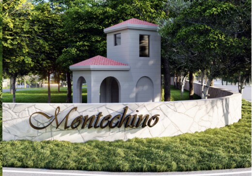
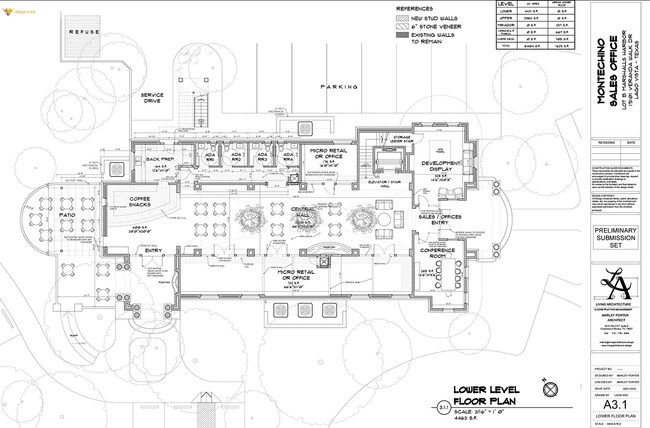
19101 Veranda Walk
Austin-Round Rock-San Marcos, TX
LOT B MARSHALLS HARBOR
498190
TRAVIS
Officebuilding
Texas
B and X Area of moderate flood hazard, usually the area between the limits of the 100-year and 500-year floods.
b
2025
3.80 AC
2025
Far Northwest
037600
Austin
7,114 SF
NEARBY LISTINGS FOR SALE OR LEASE
DEMOGRAPHICS near 19101 Veranda Walk
1 mile
3 mile
5 mile
2025 Total Population
457
13,549
40,100
2030 Population
494
14,732
43,094
Pop Growth 2025-2030
+ 8.10%
+ 8.73%
+ 7.47%
Average Age
48
48
47
2025 Total Households
201
5,814
16,837
HH Growth 2025-2030
+ 8.96%
+ 9.36%
+ 8.14%
Median Household Inc
$99,012
$104,802
$122,321
Avg Household Size
2.30
2.30
2.40
2025 Avg HH Vehicles
2.00
2.00
2.00
Median Home Value
$434,285
$511,350
$678,257
Median Year Built
2003
2003
2002
Nearby Places
Map Layers
Map Styles
 Street
 Aerial
Layers
 Traffic
 Biking
Places
Listings with unknown addresses are not visible on the map
- Restaurants
- Banks
- Shops
- Fitness
- Groceries
PUBLIC TRANSPORTATION
AIRPORT
Austin-Bergstrom International
Drive
Walk
Distance
Austin-Bergstrom International
72 min
46.7 mi
SALE & LEASE HISTORY
LISTING DATE
SALE/LEASE

Sep 12, 2023
For Lease
Feb 20, 2025
For Sale
Nearby Properties
Address
Land Use
TOTAL SIZE
Lot Size
Zoning
Address
Land Use
TOTAL SIZE
Lot Size
Zoning
110,273 SF
8.84 AC
Address
Land Use
TOTAL SIZE
Lot Size
Zoning
158.53 AC
Address
Land Use
TOTAL SIZE
Lot Size
Zoning
14,351 SF
2.74 AC
Address
Land Use
TOTAL SIZE
Lot Size
Zoning
68,888 SF
10.21 AC
Address
Land Use
TOTAL SIZE
Lot Size
Zoning
17,596 SF
2.15 AC
Address
Land Use
TOTAL SIZE
Lot Size
Zoning
3,712 SF
109.49 AC
Address
Land Use
TOTAL SIZE
Lot Size
Zoning
8,799 SF
37.53 AC
Address
Land Use
TOTAL SIZE
Lot Size
Zoning
59,980 SF
72.88 AC
Address
Land Use
TOTAL SIZE
Lot Size
Zoning
59.37 AC
Address
Land Use
TOTAL SIZE
Lot Size
Zoning
21,955 SF
74.12 AC
Address
Land Use
TOTAL SIZE
Lot Size
Zoning
59,980 SF
1.56 AC
Address
Land Use
TOTAL SIZE
Lot Size
Zoning
22,198 SF
8.56 AC
Address
Land Use
TOTAL SIZE
Lot Size
Zoning
9,390 SF
60.05 AC
Address
Land Use
TOTAL SIZE
Lot Size
Zoning
19,330 SF
7.64 AC
Address
Land Use
TOTAL SIZE
Lot Size
Zoning
16,136 SF
5.53 AC
Address
Land Use
TOTAL SIZE
Lot Size
Zoning
1 SF
111.01 AC
Address
Land Use
TOTAL SIZE
Lot Size
Zoning
21,739 SF
7.45 AC
Address
Land Use
TOTAL SIZE
Lot Size
Zoning
3.56 AC
Address
Land Use
TOTAL SIZE
Lot Size
Zoning
7,111 SF
7.47 AC
Address
Land Use
TOTAL SIZE
Lot Size
Zoning
22,576 SF
2.48 AC
Address
Land Use
TOTAL SIZE
Lot Size
Zoning
11.83 AC
Address
Land Use
TOTAL SIZE
Lot Size
Zoning
20,317 SF
6.55 AC
Address
Land Use
TOTAL SIZE
Lot Size
Zoning
4,120 SF
2 AC
Address
Land Use
TOTAL SIZE
Lot Size
Zoning
4,000 SF
7.80 AC
Address
Land Use
TOTAL SIZE
Lot Size
Zoning
211.88 AC
Address
Land Use
TOTAL SIZE
Lot Size
Zoning
12,812 SF
156.95 AC
Address
Land Use
TOTAL SIZE
Lot Size
Zoning
3,398 SF
2.43 AC
Address
Land Use
TOTAL SIZE
Lot Size
Zoning
10,852 SF
1.22 AC
Address
Land Use
TOTAL SIZE
Lot Size
Zoning
28,213 SF
5.39 AC
Address
Land Use
TOTAL SIZE
Lot Size
Zoning
The World's #1 Commercial Real Estate Marketplace
Connect with us
© 2026 CoStar Group
The information above has been obtained from sources believed reliable. While we do not doubt its accuracy we have not verified it and make no guarantee, warranty or representation about it. It is your responsibility to independently confirm its accuracy and completeness. Any projections, opinions, assumptions, or estimates used are for example only and do not represent the current or future performance of the property. The value of this transaction to you depends on tax and other factors which should be evaluated by your tax, financial, and legal advisors. You and your advisors should conduct a careful, independent investigation of the property to determine to your satisfaction the suitability of the property for your needs.