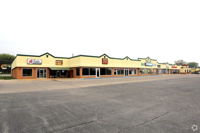
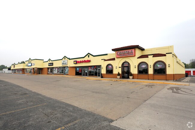
Property Record
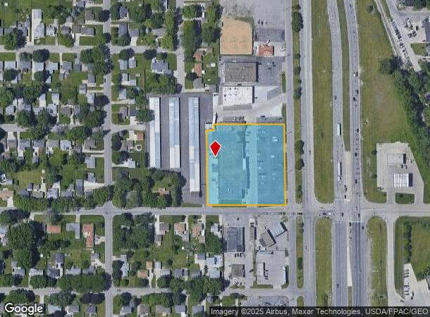
1911 E Mitchell Ave, Waterloo, IA 50702
NEARBY LISTINGS FOR SALE OR LEASE
Property Detail
1911 E Mitchell Ave
8913-36-253-010
Unplatted Waterloo West
Stripcommercialcenter
UNPLATTED WATERLOO WEST COM AT A PT THAT IS 369.05 FT N & 100 FT W OF SE COR OF SE SW NE SEC 36 T 89 R 13 TH W PAR S LINE
X
Black Hawk
19013C0302F
Iowa
2024
2.45 AC
2025
Iowa City/Waterloo
001000
Other Market Areas
35,929 SF
Waterloo-Cedar Falls, IA
DEMOGRAPHICS near 1911 E Mitchell Ave
1 mile
3 mile
5 mile
2024 Total Population
7,544
51,954
75,117
2029 Population
7,458
51,737
74,644
Pop Growth 2024-2029
(1.14%)
(0.42%)
(0.63%)
Average Age
37
38
39
2024 Total Households
3,207
22,205
32,443
HH Growth 2024-2029
(1.18%)
(0.38%)
(0.62%)
Median Household Inc
$48,079
$49,496
$52,764
Avg Household Size
2.30
2.20
2.20
2024 Avg HH Vehicles
2.00
2.00
2.00
Median Home Value
$133,009
$133,856
$141,217
Median Year Built
1955
1958
1962
Nearby Places
Map Layers
Map Styles
 Street
 Aerial
Transit
 Traffic
 Biking
Places
Listings with unknown addresses are not visible on the map
- Restaurants
- Banks
- Shops
- Fitness
- Groceries
SALE & LEASE HISTORY
LISTING DATE
SALE/LEASE

May 18, 2017
For Lease
Apr 28, 2019
For Lease
Apr 04, 2018
For Lease
Nearby Properties
Address
Land Use
TOTAL SIZE
Lot Size
Zoning
Address
Land Use
TOTAL SIZE
Lot Size
Zoning
156,098 SF
52.58 AC
Address
Land Use
TOTAL SIZE
Lot Size
Zoning
596,653 SF
31.45 AC
Address
Land Use
TOTAL SIZE
Lot Size
Zoning
108,671 SF
3.72 AC
Address
Land Use
TOTAL SIZE
Lot Size
Zoning
186,130 SF
10.89 AC
Address
Land Use
TOTAL SIZE
Lot Size
Zoning
622 SF
106.81 AC
Address
Land Use
TOTAL SIZE
Lot Size
Zoning
341 SF
1.83 AC
Address
Land Use
TOTAL SIZE
Lot Size
Zoning
101,633 SF
7 AC
Address
Land Use
TOTAL SIZE
Lot Size
Zoning
110,177 SF
1.19 AC
Address
Land Use
TOTAL SIZE
Lot Size
Zoning
202,974 SF
19.11 AC
Address
Land Use
TOTAL SIZE
Lot Size
Zoning
174,244 SF
34.27 AC
Address
Land Use
TOTAL SIZE
Lot Size
Zoning
1,473 SF
25.70 AC
Address
Land Use
TOTAL SIZE
Lot Size
Zoning
2,735 SF
158.87 AC
Address
Land Use
TOTAL SIZE
Lot Size
Zoning
7,140 SF
25.91 AC
Address
Land Use
TOTAL SIZE
Lot Size
Zoning
59,565 SF
0.28 AC
Address
Land Use
TOTAL SIZE
Lot Size
Zoning
205,163 SF
15 AC
Address
Land Use
TOTAL SIZE
Lot Size
Zoning
115,819 SF
2.07 AC
Address
Land Use
TOTAL SIZE
Lot Size
Zoning
129,863 SF
11.40 AC
Address
Land Use
TOTAL SIZE
Lot Size
Zoning
125,340 SF
0.80 AC
Address
Land Use
TOTAL SIZE
Lot Size
Zoning
60,496 SF
4.96 AC
Address
Land Use
TOTAL SIZE
Lot Size
Zoning
197,968 SF
6.10 AC
Address
Land Use
TOTAL SIZE
Lot Size
Zoning
82,449 SF
10.62 AC
Address
Land Use
TOTAL SIZE
Lot Size
Zoning
157,119 SF
15.78 AC
Address
Land Use
TOTAL SIZE
Lot Size
Zoning
77,366 SF
38.51 AC
Address
Land Use
TOTAL SIZE
Lot Size
Zoning
960 SF
39.19 AC
Address
Land Use
TOTAL SIZE
Lot Size
Zoning
70,933 SF
27.58 AC
Address
Land Use
TOTAL SIZE
Lot Size
Zoning
102,131 SF
9.16 AC
Address
Land Use
TOTAL SIZE
Lot Size
Zoning
18,000 SF
141.74 AC
Address
Land Use
TOTAL SIZE
Lot Size
Zoning
71,035 SF
8.27 AC
Address
Land Use
TOTAL SIZE
Lot Size
Zoning
145,720 SF
17.98 AC
Address
Land Use
TOTAL SIZE
Lot Size
Zoning
84,388 SF
7.79 AC
The World's #1 Commercial Real Estate Marketplace
Connect with us
© 2026 CoStar Group
The information above has been obtained from sources believed reliable. While we do not doubt its accuracy we have not verified it and make no guarantee, warranty or representation about it. It is your responsibility to independently confirm its accuracy and completeness. Any projections, opinions, assumptions, or estimates used are for example only and do not represent the current or future performance of the property. The value of this transaction to you depends on tax and other factors which should be evaluated by your tax, financial, and legal advisors. You and your advisors should conduct a careful, independent investigation of the property to determine to your satisfaction the suitability of the property for your needs.