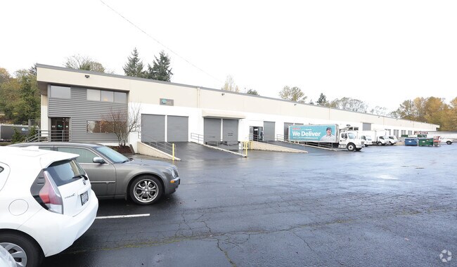
Property Record
19111 Des Moines Memorial Dr S, Seatac, WA 98148


Current Lease Availabilities
NEARBY LISTINGS FOR SALE OR LEASE
Property Detail
19111 Des Moines Memorial Dr S
322304-9302
POR S 1/2 OF S 1/2 OF SE 1/4 BEG N 05-08-12 E 30.05 FT FR SW COR OF SE 1/4 OF SE 1/4 TH N 05-08-12 E TO N LN SD S 1/2 OF S 1/2 OF SE 1/4 TH N 88-24-39 W TO WLY MGN DES MOINES WAY TH CONTG N 88-24-39 W 403.67 FT TO ELY R/W LN SR 509 SR 516 TO DES MOIN
Warehouse
King
X
Washington
53033C0962G
322304
2025
3.82 AC
2024
SeaTac/Burien
028500
Seattle/Puget Sound
74,095 SF
Seattle-Tacoma-Bellevue, WA
DEMOGRAPHICS near 19111 Des Moines Memorial Dr S
1 Mile
3 Mile
5 Mile
2024 Total Population
7,462
80,695
178,643
2029 Population
7,436
80,972
179,852
Pop Growth 2024-2029
(0.35%)
+ 0.34%
+ 0.68%
Average Age
41
40
39
2024 Total Households
2,626
30,428
66,076
HH Growth 2024-2029
(0.61%)
+ 0.12%
+ 0.50%
Median Household Inc
$117,433
$81,167
$77,517
Avg Household Size
2.60
2.50
2.60
2024 Avg HH Vehicles
2.00
2.00
2.00
Median Home Value
$531,112
$580,028
$503,308
Median Year Built
1963
1972
1974
Nearby Places
Map Layers
Map Styles
 Street
 Aerial
- Restaurants
- Banks
- Shops
- Fitness
- Groceries
PUBLIC TRANSPORTATION
COMMUTER RAIL
Tukwila Station (Sounder South Line - Central Puget Sound Regional Transit Authority Rail (Link Light Rail/Sounder))
DRIVE
WALK
Distance
Tukwila Station (Sounder South Line - Central Puget Sound Regional Transit Authority Rail (Link Light Rail/Sounder))
13 min
7.6 mi
Kent Station (Sounder South Line - Central Puget Sound Regional Transit Authority Rail (Link Light Rail/Sounder))
DRIVE
WALK
Distance
Kent Station (Sounder South Line - Central Puget Sound Regional Transit Authority Rail (Link Light Rail/Sounder))
16 min
8.0 mi
AIRPORT
Seattle-Tacoma International
DRIVE
WALK
Distance
Seattle-Tacoma International
10 min
2.3 mi
Seattle Paine Field International
DRIVE
WALK
Distance
Seattle Paine Field International
54 min
36.9 mi
Freight Ports
Port of Seattle
DRIVE
WALK
Distance
Port of Seattle
20 min
10.8 mi
Nearby Properties
Address
Land Use
TOTAL SIZE
Lot Size
Zoning
Address
Land Use
TOTAL SIZE
Lot Size
Zoning
31,032 SF
1,746.88 AC
AVO
Address
Land Use
TOTAL SIZE
Lot Size
Zoning
704,186 SF
21.86 AC
I
Address
Land Use
TOTAL SIZE
Lot Size
Zoning
213,468 SF
23.67 AC
CB-C
Address
Land Use
TOTAL SIZE
Lot Size
Zoning
358,292 SF
18.98 AC
I-C
Address
Land Use
TOTAL SIZE
Lot Size
Zoning
298,150 SF
9.04 AC
CB-C
Address
Land Use
TOTAL SIZE
Lot Size
Zoning
139,868 SF
6.64 AC
O
Address
Land Use
TOTAL SIZE
Lot Size
Zoning
458,197 SF
23.83 AC
I2
Address
Land Use
TOTAL SIZE
Lot Size
Zoning
436,880 SF
25.62 AC
AVC
Address
Land Use
TOTAL SIZE
Lot Size
Zoning
130,200 SF
9.55 AC
CB-C
Address
Land Use
TOTAL SIZE
Lot Size
Zoning
245,078 SF
6.32 AC
MCR
Address
Land Use
TOTAL SIZE
Lot Size
Zoning
434,002 SF
19.74 AC
I2
Address
Land Use
TOTAL SIZE
Lot Size
Zoning
398,364 SF
19.83 AC
I2
Address
Land Use
TOTAL SIZE
Lot Size
Zoning
348,445 SF
14.93 AC
B-P
Address
Land Use
TOTAL SIZE
Lot Size
Zoning
324,839 SF
15.80 AC
HI
Address
Land Use
TOTAL SIZE
Lot Size
Zoning
325,494 SF
23.53 AC
AI-2
Address
Land Use
TOTAL SIZE
Lot Size
Zoning
156,248 SF
15.64 AC
R-SE
Address
Land Use
TOTAL SIZE
Lot Size
Zoning
299,975 SF
11.26 AC
PR-C
Address
Land Use
TOTAL SIZE
Lot Size
Zoning
226,771 SF
14.95 AC
CB-C
Address
Land Use
TOTAL SIZE
Lot Size
Zoning
293,349 SF
3.54 AC
B-P
Address
Land Use
TOTAL SIZE
Lot Size
Zoning
306,678 SF
12.59 AC
HI
Address
Land Use
TOTAL SIZE
Lot Size
Zoning
245,520 SF
9.98 AC
B-P
Address
Land Use
TOTAL SIZE
Lot Size
Zoning
248,499 SF
11.50 AC
PR-C
Address
Land Use
TOTAL SIZE
Lot Size
Zoning
293,831 SF
16.41 AC
TUC-CC
Address
Land Use
TOTAL SIZE
Lot Size
Zoning
236,919 SF
13.40 AC
AI-1
Address
Land Use
TOTAL SIZE
Lot Size
Zoning
215,040 SF
12.19 AC
MR-M
Address
Land Use
TOTAL SIZE
Lot Size
Zoning
276,330 SF
11.70 AC
I2
Address
Land Use
TOTAL SIZE
Lot Size
Zoning
256,409 SF
17.60 AC
RS-7200
Address
Land Use
TOTAL SIZE
Lot Size
Zoning
19,008 SF
12.79 AC
RBX
Address
Land Use
TOTAL SIZE
Lot Size
Zoning
239,823 SF
11.32 AC
HI
The World's #1 Commercial Real Estate Marketplace
Connect with us
© 2026 CoStar Group
The information above has been obtained from sources believed reliable. While we do not doubt its accuracy we have not verified it and make no guarantee, warranty or representation about it. It is your responsibility to independently confirm its accuracy and completeness. Any projections, opinions, assumptions, or estimates used are for example only and do not represent the current or future performance of the property. The value of this transaction to you depends on tax and other factors which should be evaluated by your tax, financial, and legal advisors. You and your advisors should conduct a careful, independent investigation of the property to determine to your satisfaction the suitability of the property for your needs.