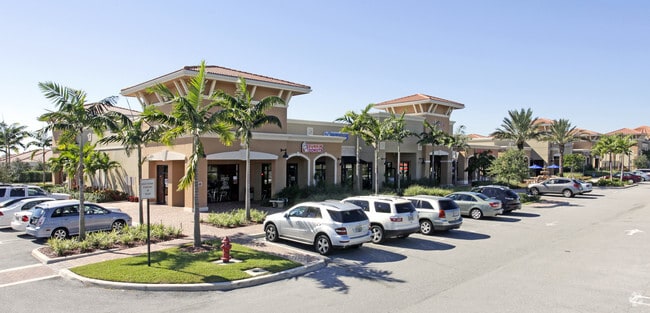
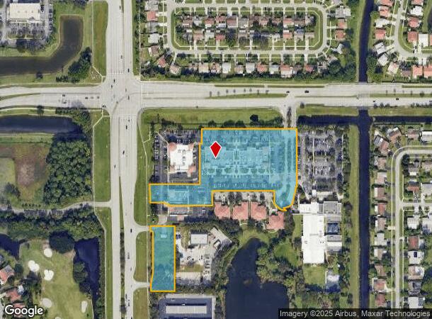
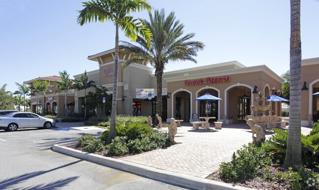
Property Record
19120 State Road 7, Boca Raton, FL 33498

NEARBY LISTINGS FOR SALE OR LEASE
Property Detail
19120 State Road 7
00-42-47-07-22-001-0010
Yamato Court
Storemultistory
YAMATO COURT MUPD TR A (LESS NLY 117.26 FT OF SLY 437.26 FT OF WLY 308.75 FT K/A BANK PARCEL & NLY 272.22 FT OF WLY 258.05 FT K/A CVS
X
Palm Beach
12099C0965F
Florida
2024
0.82 AC
2025
Boca Raton West
007749
South Florida
26,604 SF
West Palm Beach-Boca Raton-Delray Beach, FL
DEMOGRAPHICS near 19120 State Road 7
1 Mile
3 Mile
5 Mile
2024 Total Population
10,474
63,275
169,258
2029 Population
10,617
65,861
175,077
Pop Growth 2024-2029
+ 1.37%
+ 4.09%
+ 3.44%
Average Age
42
49
47
2024 Total Households
3,691
27,483
70,181
HH Growth 2024-2029
+ 0.60%
+ 4.03%
+ 3.35%
Median Household Inc
$90,558
$80,423
$79,300
Avg Household Size
2.60
2.20
2.30
2024 Avg HH Vehicles
2.00
2.00
2.00
Median Home Value
$381,937
$383,003
$405,986
Median Year Built
1986
1986
1986
Nearby Places
Map Layers
Map Styles
 Street
 Aerial
- Restaurants
- Banks
- Shops
- Fitness
- Groceries
PUBLIC TRANSPORTATION
COMMUTER RAIL
Boca Raton (Tri-County Commuter - South Florida Regional Transportation Authority (Tri-Rail))
DRIVE
WALK
Distance
Boca Raton (Tri-County Commuter - South Florida Regional Transportation Authority (Tri-Rail))
12 min
6.6 mi
AIRPORT
Palm Beach International
DRIVE
WALK
Distance
Palm Beach International
38 min
26.9 mi
Fort Lauderdale/Hollywood International
DRIVE
WALK
Distance
Fort Lauderdale/Hollywood International
43 min
30.6 mi
Freight Ports
Port Everglades
DRIVE
WALK
Distance
Port Everglades
42 min
29.2 mi
SALE & LEASE HISTORY
LISTING DATE
SALE/LEASE

Jun 28, 2021
For Lease
Nearby Properties
Address
Land Use
TOTAL SIZE
Lot Size
Zoning
Address
Land Use
TOTAL SIZE
Lot Size
Zoning
642,666 SF
16.33 AC
MXPD
Address
Land Use
TOTAL SIZE
Lot Size
Zoning
743,452 SF
25.24 AC
RTS
Address
Land Use
TOTAL SIZE
Lot Size
Zoning
30,972 SF
540.02 AC
PO
Address
Land Use
TOTAL SIZE
Lot Size
Zoning
477,479 SF
26.73 AC
RTS
Address
Land Use
TOTAL SIZE
Lot Size
Zoning
360,216 SF
17.35 AC
PUD
Address
Land Use
TOTAL SIZE
Lot Size
Zoning
353,440 SF
9.80 AC
PUD
Address
Land Use
TOTAL SIZE
Lot Size
Zoning
8,925 SF
108.70 AC
PUD
Address
Land Use
TOTAL SIZE
Lot Size
Zoning
237,919 SF
23.46 AC
CG
Address
Land Use
TOTAL SIZE
Lot Size
Zoning
294,734 SF
59.90 AC
RS
Address
Land Use
TOTAL SIZE
Lot Size
Zoning
205,022 SF
19.03 AC
MXPD
Address
Land Use
TOTAL SIZE
Lot Size
Zoning
42,054 SF
318.18 AC
PO
Address
Land Use
TOTAL SIZE
Lot Size
Zoning
144,276 SF
17.74 AC
MUPD
Address
Land Use
TOTAL SIZE
Lot Size
Zoning
201,834 SF
22.09 AC
CG
Address
Land Use
TOTAL SIZE
Lot Size
Zoning
177,218 SF
17.79 AC
CG
Address
Land Use
TOTAL SIZE
Lot Size
Zoning
146,565 SF
17.06 AC
CG
Address
Land Use
TOTAL SIZE
Lot Size
Zoning
188,849 SF
14.70 AC
CSH
Address
Land Use
TOTAL SIZE
Lot Size
Zoning
173,197 SF
19.28 AC
CG
Address
Land Use
TOTAL SIZE
Lot Size
Zoning
255,444 SF
8.45 AC
IL
Address
Land Use
TOTAL SIZE
Lot Size
Zoning
119,203 SF
12.46 AC
MUPD
Address
Land Use
TOTAL SIZE
Lot Size
Zoning
73,638 SF
9.74 AC
RE
Address
Land Use
TOTAL SIZE
Lot Size
Zoning
94,309 SF
11.15 AC
AR
Address
Land Use
TOTAL SIZE
Lot Size
Zoning
5,850 SF
70.06 AC
PUD
Address
Land Use
TOTAL SIZE
Lot Size
Zoning
115,735 SF
17.29 AC
RT
Address
Land Use
TOTAL SIZE
Lot Size
Zoning
140,710 SF
20.96 AC
R1D-PUD
Address
Land Use
TOTAL SIZE
Lot Size
Zoning
204,729 SF
16.70 AC
RTS
Address
Land Use
TOTAL SIZE
Lot Size
Zoning
155,931 SF
4 AC
MUPD
Address
Land Use
TOTAL SIZE
Lot Size
Zoning
163,893 SF
8.85 AC
MUPD
Address
Land Use
TOTAL SIZE
Lot Size
Zoning
135,863 SF
7.72 AC
CG
Address
Land Use
TOTAL SIZE
Lot Size
Zoning
96,286 SF
7.41 AC
CG
Address
Land Use
TOTAL SIZE
Lot Size
Zoning
123,716 SF
17.16 AC
RT
The World's #1 Commercial Real Estate Marketplace
Connect with us
© 2026 CoStar Group
The information above has been obtained from sources believed reliable. While we do not doubt its accuracy we have not verified it and make no guarantee, warranty or representation about it. It is your responsibility to independently confirm its accuracy and completeness. Any projections, opinions, assumptions, or estimates used are for example only and do not represent the current or future performance of the property. The value of this transaction to you depends on tax and other factors which should be evaluated by your tax, financial, and legal advisors. You and your advisors should conduct a careful, independent investigation of the property to determine to your satisfaction the suitability of the property for your needs.