Property Record
1914 Martin Rd, Mogadore, OH 44260
NEARBY LISTINGS FOR SALE OR LEASE
-
-
View all Mogadore listings for sale on LoopNet.com
Property Detail
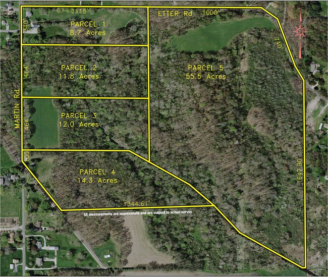
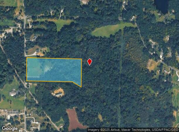
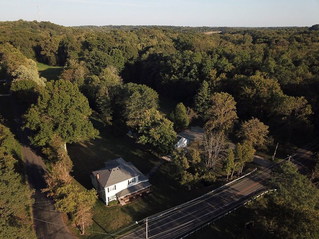
1914 Martin Rd
Akron, OH
Wilson S W
36-044-00-00-030-000
LOT 44
Agriculturalland
Portage
X
Ohio
39153C0220F
44
2024
12.76 AC
2024
Portage County
602101
Cleveland
3,628 SF
DEMOGRAPHICS near 1914 Martin Rd
1 Mile
3 Mile
5 Mile
2024 Total Population
1,650
20,950
72,730
2029 Population
1,655
20,816
72,075
Pop Growth 2024-2029
+ 0.30%
(0.64%)
(0.90%)
Average Age
45
44
43
2024 Total Households
674
8,987
30,726
HH Growth 2024-2029
+ 0.30%
(0.70%)
(0.97%)
Median Household Inc
$65,986
$58,134
$63,685
Avg Household Size
2.40
2.30
2.30
2024 Avg HH Vehicles
2.00
2.00
2.00
Median Home Value
$181,156
$150,803
$158,754
Median Year Built
1964
1963
1964
Nearby Places
Map Layers
Map Styles
 Street
 Aerial
- Restaurants
- Banks
- Shops
- Fitness
- Groceries
PUBLIC TRANSPORTATION
AIRPORT
Akron-Canton Regional
DRIVE
WALK
Distance
Akron-Canton Regional
24 min
12.8 mi
Freight Ports
Port of Toledo
DRIVE
WALK
Distance
Port of Toledo
172 min
140.6 mi
SALE & LEASE HISTORY
LISTING DATE
SALE/LEASE

Sep 30, 2019
For Sale
Nearby Properties
Address
Land Use
TOTAL SIZE
Lot Size
Zoning
Address
Land Use
TOTAL SIZE
Lot Size
Zoning
162,774 SF
16.58 AC
Address
Land Use
TOTAL SIZE
Lot Size
Zoning
115,586 SF
4.93 AC
Address
Land Use
TOTAL SIZE
Lot Size
Zoning
168,889 SF
30.80 AC
Address
Land Use
TOTAL SIZE
Lot Size
Zoning
882,093 SF
50.96 AC
Address
Land Use
TOTAL SIZE
Lot Size
Zoning
124,939 SF
13.89 AC
Address
Land Use
TOTAL SIZE
Lot Size
Zoning
667,050 SF
24.55 AC
Address
Land Use
TOTAL SIZE
Lot Size
Zoning
53,454 SF
3.78 AC
Address
Land Use
TOTAL SIZE
Lot Size
Zoning
97,454 SF
3.14 AC
Address
Land Use
TOTAL SIZE
Lot Size
Zoning
329,075 SF
14.11 AC
Address
Land Use
TOTAL SIZE
Lot Size
Zoning
291,490 SF
14 AC
Address
Land Use
TOTAL SIZE
Lot Size
Zoning
76,000 SF
4 AC
Address
Land Use
TOTAL SIZE
Lot Size
Zoning
248,589 SF
25.31 AC
Address
Land Use
TOTAL SIZE
Lot Size
Zoning
328,600 SF
19.36 AC
Address
Land Use
TOTAL SIZE
Lot Size
Zoning
Address
Land Use
TOTAL SIZE
Lot Size
Zoning
273,024 SF
14 AC
Address
Land Use
TOTAL SIZE
Lot Size
Zoning
46,540 SF
7.03 AC
Address
Land Use
TOTAL SIZE
Lot Size
Zoning
120,480 SF
5.45 AC
Address
Land Use
TOTAL SIZE
Lot Size
Zoning
353,162 SF
9.67 AC
Address
Land Use
TOTAL SIZE
Lot Size
Zoning
60,721 SF
7.46 AC
Address
Land Use
TOTAL SIZE
Lot Size
Zoning
144,900 SF
7.24 AC
Address
Land Use
TOTAL SIZE
Lot Size
Zoning
131,820 SF
4.77 AC
Address
Land Use
TOTAL SIZE
Lot Size
Zoning
55,520 SF
5.81 AC
Address
Land Use
TOTAL SIZE
Lot Size
Zoning
45,942 SF
14.29 AC
Address
Land Use
TOTAL SIZE
Lot Size
Zoning
36,184 SF
5.03 AC
Address
Land Use
TOTAL SIZE
Lot Size
Zoning
7,425 SF
14.13 AC
Address
Land Use
TOTAL SIZE
Lot Size
Zoning
88,400 SF
5.58 AC
Address
Land Use
TOTAL SIZE
Lot Size
Zoning
16,838 SF
0.75 AC
Address
Land Use
TOTAL SIZE
Lot Size
Zoning
86,016 SF
5.05 AC
Address
Land Use
TOTAL SIZE
Lot Size
Zoning
13,904 SF
8.18 AC
Address
Land Use
TOTAL SIZE
Lot Size
Zoning
63,105 SF
4.66 AC
The World's #1 Commercial Real Estate Marketplace
Connect with us
© 2025 CoStar Group
The information above has been obtained from sources believed reliable. While we do not doubt its accuracy we have not verified it and make no guarantee, warranty or representation about it. It is your responsibility to independently confirm its accuracy and completeness. Any projections, opinions, assumptions, or estimates used are for example only and do not represent the current or future performance of the property. The value of this transaction to you depends on tax and other factors which should be evaluated by your tax, financial, and legal advisors. You and your advisors should conduct a careful, independent investigation of the property to determine to your satisfaction the suitability of the property for your needs.