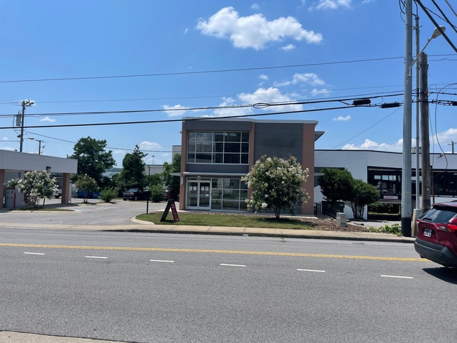
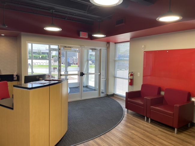
Property Record
1915 Glen Echo Rd, Nashville, TN 37215

This Property Is For Sale
NEARBY LISTINGS FOR SALE OR LEASE
Property Detail
1915 Glen Echo Rd
Nashville-Davidson--Murfreesboro--Franklin, TN
A R A
117-15-0-169
LOT 1 A.R.A. SUB 1ST REV
Financialbuilding
Davidson
X
Tennessee
47037C0356H
1
2025
0.43 AC
2025
Green Hills-Belle Mde
017702
Nashville
3,546 SF
DEMOGRAPHICS near 1915 Glen Echo Rd
1 Mile
3 Mile
5 Mile
2024 Total Population
10,256
84,440
204,871
2029 Population
10,030
83,832
206,585
Pop Growth 2024-2029
(2.20%)
(0.72%)
+ 0.84%
Average Age
42
37
37
2024 Total Households
4,798
36,391
92,481
HH Growth 2024-2029
(2.63%)
(0.92%)
+ 1.09%
Median Household Inc
$113,547
$100,439
$72,921
Avg Household Size
2.00
2.00
2.00
2024 Avg HH Vehicles
2.00
2.00
2.00
Median Home Value
$772,626
$805,374
$593,328
Median Year Built
1981
1982
1989
Nearby Places
Map Layers
Map Styles
 Street
 Aerial
- Restaurants
- Banks
- Shops
- Fitness
- Groceries
PUBLIC TRANSPORTATION
COMMUTER RAIL
Riverfront (East Corridor Line - Tennessee Regional Transportation Authority Music City Star (Music City Star))
DRIVE
WALK
Distance
Riverfront (East Corridor Line - Tennessee Regional Transportation Authority Music City Star (Music City Star))
9 min
4.7 mi
AIRPORT
Nashville International
DRIVE
WALK
Distance
Nashville International
16 min
9.9 mi
Nearby Properties
Address
Land Use
TOTAL SIZE
Lot Size
Zoning
Address
Land Use
TOTAL SIZE
Lot Size
Zoning
6,216 SF
131.92 AC
MULTI-ZONE
Address
Land Use
TOTAL SIZE
Lot Size
Zoning
30,648 SF
37.73 AC
ORI
Address
Land Use
TOTAL SIZE
Lot Size
Zoning
5,397 SF
36.19 AC
MULTI-ZONE
Address
Land Use
TOTAL SIZE
Lot Size
Zoning
1,339,972 SF
16.18 AC
ORI
Address
Land Use
TOTAL SIZE
Lot Size
Zoning
17.48 AC
MUG
Address
Land Use
TOTAL SIZE
Lot Size
Zoning
57,264 SF
7.80 AC
MUI
Address
Land Use
TOTAL SIZE
Lot Size
Zoning
24.42 AC
ORI
Address
Land Use
TOTAL SIZE
Lot Size
Zoning
13,764 SF
21 AC
SCR
Address
Land Use
TOTAL SIZE
Lot Size
Zoning
28.23 AC
MULTI-ZONE
Address
Land Use
TOTAL SIZE
Lot Size
Zoning
15.48 AC
MUI
Address
Land Use
TOTAL SIZE
Lot Size
Zoning
17.03 AC
ORI
Address
Land Use
TOTAL SIZE
Lot Size
Zoning
207,950 SF
3.47 AC
RM20
Address
Land Use
TOTAL SIZE
Lot Size
Zoning
315,516 SF
3.72 AC
SP
Address
Land Use
TOTAL SIZE
Lot Size
Zoning
146,363 SF
51.69 AC
CS
Address
Land Use
TOTAL SIZE
Lot Size
Zoning
414,234 SF
2.57 AC
SCR
Address
Land Use
TOTAL SIZE
Lot Size
Zoning
556,277 SF
1.85 AC
SP
Address
Land Use
TOTAL SIZE
Lot Size
Zoning
76,787 SF
3.86 AC
3ZZ
Address
Land Use
TOTAL SIZE
Lot Size
Zoning
184,700 SF
14.20 AC
RM40
Address
Land Use
TOTAL SIZE
Lot Size
Zoning
9.31 AC
MULTI-ZONE
Address
Land Use
TOTAL SIZE
Lot Size
Zoning
80,280 SF
2.20 AC
OVUDO
Address
Land Use
TOTAL SIZE
Lot Size
Zoning
21,706 SF
7.85 AC
RM20
Address
Land Use
TOTAL SIZE
Lot Size
Zoning
101,601 SF
2 AC
MUG
Address
Land Use
TOTAL SIZE
Lot Size
Zoning
315,636 SF
1.56 AC
MUG
Address
Land Use
TOTAL SIZE
Lot Size
Zoning
133,157 SF
1.05 AC
ORI
Address
Land Use
TOTAL SIZE
Lot Size
Zoning
361,179 SF
1.94 AC
SP
Address
Land Use
TOTAL SIZE
Lot Size
Zoning
345,528 SF
1.46 AC
SCR
Address
Land Use
TOTAL SIZE
Lot Size
Zoning
121,769 SF
4.64 AC
MULTI-ZONE
Address
Land Use
TOTAL SIZE
Lot Size
Zoning
291,619 SF
MUIA
Address
Land Use
TOTAL SIZE
Lot Size
Zoning
23,999 SF
9.05 AC
SCR
Address
Land Use
TOTAL SIZE
Lot Size
Zoning
377,977 SF
2.66 AC
MUG-A
The World's #1 Commercial Real Estate Marketplace
Connect with us
© 2026 CoStar Group
The information above has been obtained from sources believed reliable. While we do not doubt its accuracy we have not verified it and make no guarantee, warranty or representation about it. It is your responsibility to independently confirm its accuracy and completeness. Any projections, opinions, assumptions, or estimates used are for example only and do not represent the current or future performance of the property. The value of this transaction to you depends on tax and other factors which should be evaluated by your tax, financial, and legal advisors. You and your advisors should conduct a careful, independent investigation of the property to determine to your satisfaction the suitability of the property for your needs.