Property Record
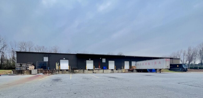
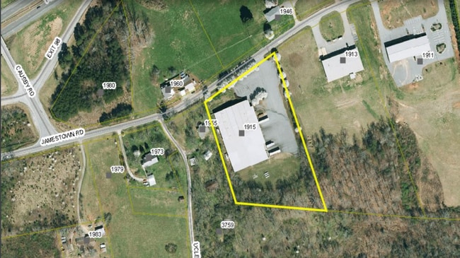
1915 Jamestown Rd, Morganton, NC 28655

Property Detail
1915 Jamestown Rd
46750
1915 JAMESTOWN RD MORGANTON, NC 28655
Warehouse
Burke
INDUSTRIAL
North Carolina
B and X Area of moderate flood hazard, usually the area between the limits of the 100-year and 500-year floods.
4.05 AC
2025
Burke County
2025
Charlotte
020303
Hickory-Lenoir-Morganton, NC
36,000 SF
NEARBY LISTINGS FOR SALE OR LEASE
DEMOGRAPHICS near 1915 Jamestown Rd
1 mile
3 mile
5 mile
2025 Total Population
1,123
8,342
21,676
2030 Population
1,141
8,421
22,120
Pop Growth 2025-2030
+ 1.60%
+ 0.95%
+ 2.05%
Average Age
45
44
44
2025 Total Households
445
3,370
8,783
HH Growth 2025-2030
+ 1.57%
+ 0.98%
+ 2.13%
Median Household Inc
$61,196
$52,202
$53,004
Avg Household Size
2.50
2.40
2.40
2025 Avg HH Vehicles
2.00
2.00
2.00
Median Home Value
$160,908
$200,543
$216,756
Median Year Built
1988
1982
1981
Nearby Places
Map Layers
Map Styles
 Street
 Aerial
Layers
 Traffic
 Biking
Places
Listings with unknown addresses are not visible on the map
- Restaurants
- Banks
- Shops
- Fitness
- Groceries
SALE & LEASE HISTORY
LISTING DATE
SALE/LEASE

Sep 25, 2016
For Lease
Sep 24, 2016
For Sale
Jul 14, 2023
For Lease
Jan 16, 2025
For Sale
Dec 17, 2024
For Sale
Nearby Properties
Address
Land Use
TOTAL SIZE
Lot Size
Zoning
Address
Land Use
TOTAL SIZE
Lot Size
Zoning
73,872 SF
LOW INTENS
Address
Land Use
TOTAL SIZE
Lot Size
Zoning
299,860 SF
39.81 AC
EXCLUSIVE
Address
Land Use
TOTAL SIZE
Lot Size
Zoning
510,924 SF
138.59 AC
EXCLUSIVE
Address
Land Use
TOTAL SIZE
Lot Size
Zoning
241,540 SF
36.93 AC
EXCLUSIVE
Address
Land Use
TOTAL SIZE
Lot Size
Zoning
165,508 SF
40.83 AC
EXCLUSIVE
Address
Land Use
TOTAL SIZE
Lot Size
Zoning
31.48 AC
INDUSTRIAL
Address
Land Use
TOTAL SIZE
Lot Size
Zoning
229,703 SF
48.54 AC
EXCLUSIVE
Address
Land Use
TOTAL SIZE
Lot Size
Zoning
10,139 SF
RESIDENTIA
Address
Land Use
TOTAL SIZE
Lot Size
Zoning
13,500 SF
RESIDENTIA
Address
Land Use
TOTAL SIZE
Lot Size
Zoning
17,752 SF
LOW DENSIT
Address
Land Use
TOTAL SIZE
Lot Size
Zoning
58,166 SF
47.63 AC
RURAL MIXE
Address
Land Use
TOTAL SIZE
Lot Size
Zoning
24,225 SF
13.45 AC
HIGH INTEN
Address
Land Use
TOTAL SIZE
Lot Size
Zoning
8,765 SF
12.62 AC
EXCLUSIVE
Address
Land Use
TOTAL SIZE
Lot Size
Zoning
283,636 SF
75.24 AC
EXCLUSIVE
Address
Land Use
TOTAL SIZE
Lot Size
Zoning
287,497 SF
27.25 AC
EXCLUSIVE
Address
Land Use
TOTAL SIZE
Lot Size
Zoning
108,850 SF
10.19 AC
EXCLUSIVE
Address
Land Use
TOTAL SIZE
Lot Size
Zoning
75,712 SF
24.51 AC
HIGH INTEN
Address
Land Use
TOTAL SIZE
Lot Size
Zoning
21,179 SF
6.95 AC
CONDITIONA
Address
Land Use
TOTAL SIZE
Lot Size
Zoning
111,009 SF
20.65 AC
EXCLUSIVE
Address
Land Use
TOTAL SIZE
Lot Size
Zoning
52,440 SF
11.79 AC
EXCLUSIVE
Address
Land Use
TOTAL SIZE
Lot Size
Zoning
6,373 SF
10.13 AC
MEDIUM INT
Address
Land Use
TOTAL SIZE
Lot Size
Zoning
6,770 SF
LOW DENSIT
Address
Land Use
TOTAL SIZE
Lot Size
Zoning
16,424 SF
11.95 AC
OFFICE INS
Address
Land Use
TOTAL SIZE
Lot Size
Zoning
61,852 SF
5.01 AC
EXCLUSIVE
Address
Land Use
TOTAL SIZE
Lot Size
Zoning
9,726 SF
6.81 AC
EXCLUSIVE
Address
Land Use
TOTAL SIZE
Lot Size
Zoning
8,301 SF
RESIDENTIA
Address
Land Use
TOTAL SIZE
Lot Size
Zoning
9,100 SF
0.55 AC
GENERAL BU
Address
Land Use
TOTAL SIZE
Lot Size
Zoning
27,000 SF
5.07 AC
EXCLUSIVE
Address
Land Use
TOTAL SIZE
Lot Size
Zoning
3,597 SF
1.29 AC
HIGH INTEN
The World's #1 Commercial Real Estate Marketplace
Connect with us
© 2026 CoStar Group
The information above has been obtained from sources believed reliable. While we do not doubt its accuracy we have not verified it and make no guarantee, warranty or representation about it. It is your responsibility to independently confirm its accuracy and completeness. Any projections, opinions, assumptions, or estimates used are for example only and do not represent the current or future performance of the property. The value of this transaction to you depends on tax and other factors which should be evaluated by your tax, financial, and legal advisors. You and your advisors should conduct a careful, independent investigation of the property to determine to your satisfaction the suitability of the property for your needs.