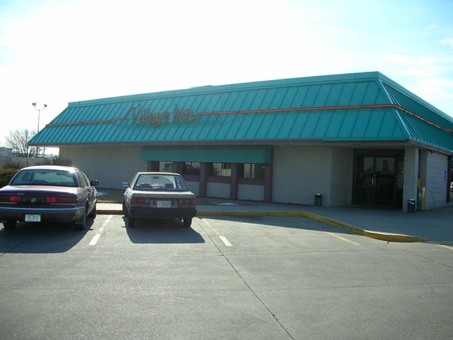
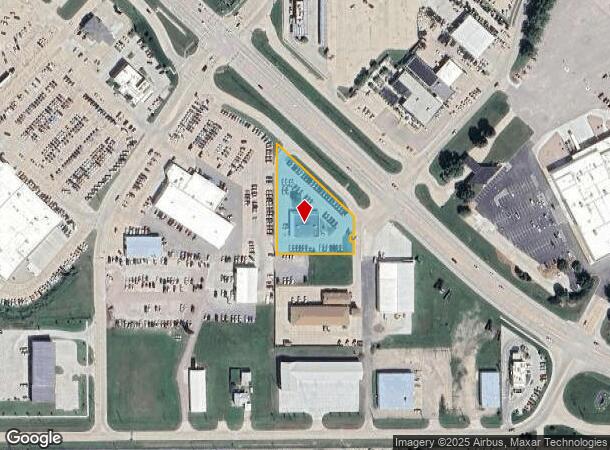
Property Record
1915 Krenzien Dr, Norfolk, NE 68701
NEARBY LISTINGS FOR SALE OR LEASE
Property Detail
1915 Krenzien Dr
Norfolk, NE
Desais Second Add
590126210
DESAIS SECOND ADDITION LOT 1-R; MAP NUMBER: 1501-00-0-60880-000-0001
Vehiclerentalsvehiclesales
Madison
X
Nebraska
31119C0095D
1
2024
1.10 AC
2024
Nebraska Area
961100
Other Market Areas
5,065 SF
DEMOGRAPHICS near 1915 Krenzien Dr
1 Mile
3 Mile
5 Mile
2024 Total Population
4,964
26,038
28,899
2029 Population
5,060
25,944
28,754
Pop Growth 2024-2029
+ 1.93%
(0.36%)
(0.50%)
Average Age
40
39
39
2024 Total Households
2,019
10,576
11,631
HH Growth 2024-2029
+ 2.08%
(0.41%)
(0.54%)
Median Household Inc
$44,823
$55,242
$56,528
Avg Household Size
2.30
2.30
2.30
2024 Avg HH Vehicles
2.00
2.00
2.00
Median Home Value
$143,814
$189,452
$190,129
Median Year Built
1973
1975
1975
Nearby Places
Map Layers
Map Styles
 Street
 Aerial
- Restaurants
- Banks
- Shops
- Fitness
- Groceries
Nearby Properties
Address
Land Use
TOTAL SIZE
Lot Size
Zoning
Address
Land Use
TOTAL SIZE
Lot Size
Zoning
4.86 AC
COMMERCIAL
Address
Land Use
TOTAL SIZE
Lot Size
Zoning
69,569 SF
9.59 AC
COMMERCIAL
Address
Land Use
TOTAL SIZE
Lot Size
Zoning
41,088 SF
3.71 AC
COMMERCIAL
Address
Land Use
TOTAL SIZE
Lot Size
Zoning
7,336 SF
11.73 AC
SINGLE-FAM
Address
Land Use
TOTAL SIZE
Lot Size
Zoning
42,518 SF
5.39 AC
COMMERCIAL
Address
Land Use
TOTAL SIZE
Lot Size
Zoning
1,800 SF
123.62 AC
INDUSTRIAL
Address
Land Use
TOTAL SIZE
Lot Size
Zoning
64,515 SF
8.68 AC
COMMERCIAL
Address
Land Use
TOTAL SIZE
Lot Size
Zoning
822,293 SF
47.68 AC
INDUSTRIAL
Address
Land Use
TOTAL SIZE
Lot Size
Zoning
57,589 SF
9.59 AC
COMMERCIAL
Address
Land Use
TOTAL SIZE
Lot Size
Zoning
195,720 SF
26.81 AC
COMMERCIAL
Address
Land Use
TOTAL SIZE
Lot Size
Zoning
170,912 SF
20.68 AC
COMMERCIAL
Address
Land Use
TOTAL SIZE
Lot Size
Zoning
73,706 SF
5.13 AC
COMMERCIAL
Address
Land Use
TOTAL SIZE
Lot Size
Zoning
25,645 SF
10.15 AC
MULTI-FAMI
Address
Land Use
TOTAL SIZE
Lot Size
Zoning
10.15 AC
COMMERCIAL
Address
Land Use
TOTAL SIZE
Lot Size
Zoning
102,200 SF
41.60 AC
COMMERCIAL
Address
Land Use
TOTAL SIZE
Lot Size
Zoning
64,515 SF
3.53 AC
COMMERCIAL
Address
Land Use
TOTAL SIZE
Lot Size
Zoning
2,195 SF
5.23 AC
MULTI-FAMI
Address
Land Use
TOTAL SIZE
Lot Size
Zoning
26.70 AC
COMMERCIAL
Address
Land Use
TOTAL SIZE
Lot Size
Zoning
280,568 SF
42.54 AC
INDUSTRIAL
Address
Land Use
TOTAL SIZE
Lot Size
Zoning
88,923 SF
7.42 AC
COMMERCIAL
Address
Land Use
TOTAL SIZE
Lot Size
Zoning
265,210 SF
99.99 AC
INDUSTRIAL
Address
Land Use
TOTAL SIZE
Lot Size
Zoning
183,600 SF
31.95 AC
INDUSTRIAL
Address
Land Use
TOTAL SIZE
Lot Size
Zoning
57,799 SF
16.28 AC
INDUSTRIAL
Address
Land Use
TOTAL SIZE
Lot Size
Zoning
55,680 SF
4.59 AC
COMMERCIAL
Address
Land Use
TOTAL SIZE
Lot Size
Zoning
66,096 SF
7.29 AC
COMMERCIAL
Address
Land Use
TOTAL SIZE
Lot Size
Zoning
54,928 SF
2.23 AC
COMMERCIAL
Address
Land Use
TOTAL SIZE
Lot Size
Zoning
705,348 SF
1.82 AC
MULTI-FAMI
Address
Land Use
TOTAL SIZE
Lot Size
Zoning
55,460 SF
6.51 AC
COMMERCIAL
Address
Land Use
TOTAL SIZE
Lot Size
Zoning
13,025 SF
2.55 AC
COMMERCIAL
Address
Land Use
TOTAL SIZE
Lot Size
Zoning
45,544 SF
1.18 AC
COMMERCIAL
The World's #1 Commercial Real Estate Marketplace
Connect with us
© 2025 CoStar Group
The information above has been obtained from sources believed reliable. While we do not doubt its accuracy we have not verified it and make no guarantee, warranty or representation about it. It is your responsibility to independently confirm its accuracy and completeness. Any projections, opinions, assumptions, or estimates used are for example only and do not represent the current or future performance of the property. The value of this transaction to you depends on tax and other factors which should be evaluated by your tax, financial, and legal advisors. You and your advisors should conduct a careful, independent investigation of the property to determine to your satisfaction the suitability of the property for your needs.