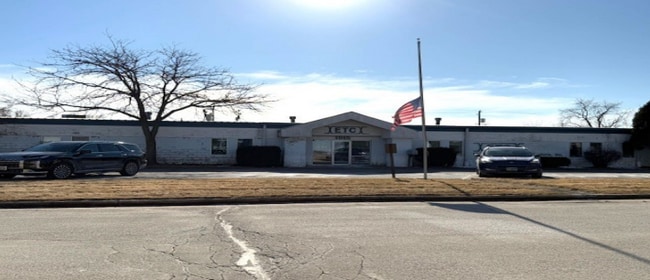
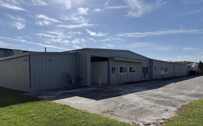
Property Record
1915 Macarthur Rd, Waukesha, WI 53188
Current Lease Availabilities
NEARBY LISTINGS FOR SALE OR LEASE
Property Detail
1915 Macarthur Rd
Milwaukee/Madison
Certified Survey
Milwaukee-Waukesha, WI
N 209.84 LOT 1 CSM NO 12183 (V124 CSM P318) PT SW1/4 OF NE1/4 & NW1/4 OF SE1/4 & NE1/4 OF SW1/4 & SE1/4 OF NW1/4 SEC 9 T6N R19E 1.448 AC DOC NO 2692258
WAKC-1329-020
Waukesha
Industrialgeneral
Wisconsin
2024
1
2024
1.44 AC
202203
Central Waukesha
DEMOGRAPHICS near 1915 Macarthur Rd
1 Mile
3 Mile
5 Mile
2024 Total Population
8,193
69,954
96,314
2029 Population
8,539
72,456
99,459
Pop Growth 2024-2029
+ 4.22%
+ 3.58%
+ 3.27%
Average Age
39
40
41
2024 Total Households
3,402
29,238
40,633
HH Growth 2024-2029
+ 4.38%
+ 3.72%
+ 3.37%
Median Household Inc
$65,945
$76,123
$79,253
Avg Household Size
2.30
2.30
2.30
2024 Avg HH Vehicles
2.00
2.00
2.00
Median Home Value
$248,449
$259,709
$278,053
Median Year Built
1978
1977
1980
Nearby Places
Map Layers
Map Styles
 Street
 Aerial
- Restaurants
- Banks
- Shops
- Fitness
- Groceries
PUBLIC TRANSPORTATION
AIRPORT
General Mitchell International
DRIVE
WALK
Distance
General Mitchell International
42 min
26.9 mi
Freight Ports
Port Milwaukee
DRIVE
WALK
Distance
Port Milwaukee
36 min
22.4 mi
Nearby Properties
Address
Land Use
TOTAL SIZE
Lot Size
Zoning
Address
Land Use
TOTAL SIZE
Lot Size
Zoning
21.73 AC
M-1
Address
Land Use
TOTAL SIZE
Lot Size
Zoning
23.09 AC
B-1(PUD),C
Address
Land Use
TOTAL SIZE
Lot Size
Zoning
71.18 AC
M-2
Address
Land Use
TOTAL SIZE
Lot Size
Zoning
68,591 SF
2.97 AC
RM-3(PUD)
Address
Land Use
TOTAL SIZE
Lot Size
Zoning
51,676 SF
7.41 AC
RM-3(PUD)
Address
Land Use
TOTAL SIZE
Lot Size
Zoning
51,676 SF
6.96 AC
RM-3(PUD)
Address
Land Use
TOTAL SIZE
Lot Size
Zoning
91,322 SF
8.48 AC
B-4
Address
Land Use
TOTAL SIZE
Lot Size
Zoning
110,992 SF
12.15 AC
RM-1(PUD)
Address
Land Use
TOTAL SIZE
Lot Size
Zoning
187,050 SF
24.37 AC
B-5, C-1
Address
Land Use
TOTAL SIZE
Lot Size
Zoning
61,299 SF
6.59 AC
RM-2(PUD)
Address
Land Use
TOTAL SIZE
Lot Size
Zoning
28,942 SF
2.31 AC
B-3(22.52)
Address
Land Use
TOTAL SIZE
Lot Size
Zoning
79,529 SF
23.85 AC
I-1
Address
Land Use
TOTAL SIZE
Lot Size
Zoning
29.41 AC
B-5(PUD)
Address
Land Use
TOTAL SIZE
Lot Size
Zoning
4.21 AC
B-5(PUD)
Address
Land Use
TOTAL SIZE
Lot Size
Zoning
24,981 SF
1.79 AC
B-3(22.52)
Address
Land Use
TOTAL SIZE
Lot Size
Zoning
11.54 AC
M-1
Address
Land Use
TOTAL SIZE
Lot Size
Zoning
102,333 SF
11.99 AC
B-5(PUD)
Address
Land Use
TOTAL SIZE
Lot Size
Zoning
11.11 AC
B-5
Address
Land Use
TOTAL SIZE
Lot Size
Zoning
0.81 AC
B-2
Address
Land Use
TOTAL SIZE
Lot Size
Zoning
47,353 SF
5.41 AC
RM-2(PUD)
Address
Land Use
TOTAL SIZE
Lot Size
Zoning
111,624 SF
12.91 AC
RM-3(PUD)
Address
Land Use
TOTAL SIZE
Lot Size
Zoning
10.31 AC
B-5
Address
Land Use
TOTAL SIZE
Lot Size
Zoning
36,054 SF
10.62 AC
I-1
Address
Land Use
TOTAL SIZE
Lot Size
Zoning
1.74 AC
RM-3(PUD)
Address
Land Use
TOTAL SIZE
Lot Size
Zoning
16.10 AC
M-2
Address
Land Use
TOTAL SIZE
Lot Size
Zoning
4.50 AC
B-5(PUD)
Address
Land Use
TOTAL SIZE
Lot Size
Zoning
24,684 SF
1.56 AC
RM-3(PUD)
Address
Land Use
TOTAL SIZE
Lot Size
Zoning
132,634 SF
9.25 AC
B-5(PUD)
Address
Land Use
TOTAL SIZE
Lot Size
Zoning
65,173 SF
3.83 AC
I-1
Address
Land Use
TOTAL SIZE
Lot Size
Zoning
9.63 AC
B-5(PUD)
The World's #1 Commercial Real Estate Marketplace
Connect with us
© 2026 CoStar Group
The information above has been obtained from sources believed reliable. While we do not doubt its accuracy we have not verified it and make no guarantee, warranty or representation about it. It is your responsibility to independently confirm its accuracy and completeness. Any projections, opinions, assumptions, or estimates used are for example only and do not represent the current or future performance of the property. The value of this transaction to you depends on tax and other factors which should be evaluated by your tax, financial, and legal advisors. You and your advisors should conduct a careful, independent investigation of the property to determine to your satisfaction the suitability of the property for your needs.