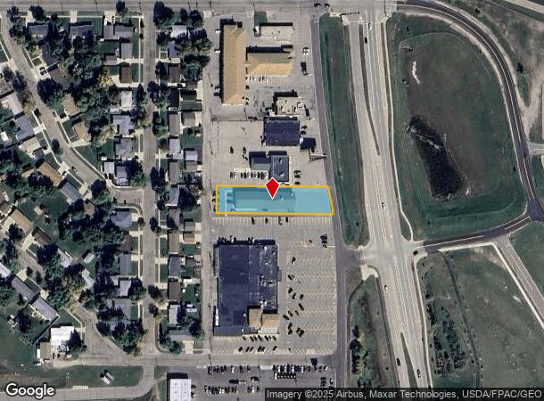
Property Record
1915 N Broadway, Minot, ND 58703

NEARBY LISTINGS FOR SALE OR LEASE
-
-
View all Minot listings for lease on LoopNet.com
Property Detail
1915 N Broadway
Other Market Areas
Andersons Subdivision
Minot, ND
Ward
MI-11006-010-006-0
North Dakota
Singlefamilyresidentialassumed
North Hill
DEMOGRAPHICS near 1915 N Broadway
1 Mile
3 Mile
5 Mile
2024 Total Population
8,758
38,004
51,661
2029 Population
8,625
37,482
50,893
Pop Growth 2024-2029
(1.52%)
(1.37%)
(1.49%)
Average Age
35
37
38
2024 Total Households
3,703
16,137
22,153
HH Growth 2024-2029
(1.84%)
(1.44%)
(1.53%)
Median Household Inc
$67,341
$69,595
$68,909
Avg Household Size
2.20
2.20
2.20
2024 Avg HH Vehicles
2.00
2.00
2.00
Median Home Value
$213,672
$232,697
$236,319
Median Year Built
1978
1977
1983
Nearby Places
Map Layers
Map Styles
 Street
 Aerial
- Restaurants
- Banks
- Shops
- Fitness
- Groceries
PUBLIC TRANSPORTATION
COMMUTER RAIL
Minot Amtrak Station (Empire Builder - Amtrak)
DRIVE
WALK
Distance
Minot Amtrak Station (Empire Builder - Amtrak)
3 min
1.6 mi
AIRPORT
Minot International
DRIVE
WALK
Distance
Minot International
4 min
1.0 mi
Freight Ports
Port Milwaukee
DRIVE
WALK
Distance
Port Milwaukee
946 min
873.0 mi
SALE & LEASE HISTORY
LISTING DATE
SALE/LEASE

Nov 18, 2016
For Sale
Dec 12, 2024
For Lease
Nearby Properties
Address
Land Use
TOTAL SIZE
Lot Size
Zoning
Address
Land Use
TOTAL SIZE
Lot Size
Zoning
121,307 SF
2.97 AC
Address
Land Use
TOTAL SIZE
Lot Size
Zoning
29,172 SF
9.19 AC
Address
Land Use
TOTAL SIZE
Lot Size
Zoning
41,710 SF
2.45 AC
Address
Land Use
TOTAL SIZE
Lot Size
Zoning
4,000 SF
59.25 AC
Address
Land Use
TOTAL SIZE
Lot Size
Zoning
46,496 SF
2.41 AC
Address
Land Use
TOTAL SIZE
Lot Size
Zoning
47,150 SF
6.43 AC
Address
Land Use
TOTAL SIZE
Lot Size
Zoning
30,000 SF
8.53 AC
Address
Land Use
TOTAL SIZE
Lot Size
Zoning
24,471 SF
1.54 AC
Address
Land Use
TOTAL SIZE
Lot Size
Zoning
31,924 SF
2.82 AC
Address
Land Use
TOTAL SIZE
Lot Size
Zoning
9.49 AC
Address
Land Use
TOTAL SIZE
Lot Size
Zoning
14,112 SF
1.71 AC
Address
Land Use
TOTAL SIZE
Lot Size
Zoning
6,120 SF
0.53 AC
Address
Land Use
TOTAL SIZE
Lot Size
Zoning
6,930 SF
0.51 AC
Address
Land Use
TOTAL SIZE
Lot Size
Zoning
12,000 SF
2 AC
Address
Land Use
TOTAL SIZE
Lot Size
Zoning
121 AC
Address
Land Use
TOTAL SIZE
Lot Size
Zoning
15,000 SF
4.57 AC
Address
Land Use
TOTAL SIZE
Lot Size
Zoning
9,900 SF
1.39 AC
Address
Land Use
TOTAL SIZE
Lot Size
Zoning
5,400 SF
0.46 AC
Address
Land Use
TOTAL SIZE
Lot Size
Zoning
6,532 SF
0.05 AC
Address
Land Use
TOTAL SIZE
Lot Size
Zoning
3,894 SF
0.62 AC
Address
Land Use
TOTAL SIZE
Lot Size
Zoning
4,244 SF
0.60 AC
Address
Land Use
TOTAL SIZE
Lot Size
Zoning
20,818 SF
1.80 AC
Address
Land Use
TOTAL SIZE
Lot Size
Zoning
34,584 SF
1.39 AC
Address
Land Use
TOTAL SIZE
Lot Size
Zoning
13.84 AC
Address
Land Use
TOTAL SIZE
Lot Size
Zoning
40.12 AC
Address
Land Use
TOTAL SIZE
Lot Size
Zoning
3,767 SF
0.47 AC
Address
Land Use
TOTAL SIZE
Lot Size
Zoning
20,839 SF
7.28 AC
The World's #1 Commercial Real Estate Marketplace
Connect with us
© 2025 CoStar Group
The information above has been obtained from sources believed reliable. While we do not doubt its accuracy we have not verified it and make no guarantee, warranty or representation about it. It is your responsibility to independently confirm its accuracy and completeness. Any projections, opinions, assumptions, or estimates used are for example only and do not represent the current or future performance of the property. The value of this transaction to you depends on tax and other factors which should be evaluated by your tax, financial, and legal advisors. You and your advisors should conduct a careful, independent investigation of the property to determine to your satisfaction the suitability of the property for your needs.