Property Record
1915 Sherwood Forest St, Houston, TX 77043
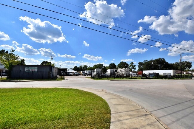
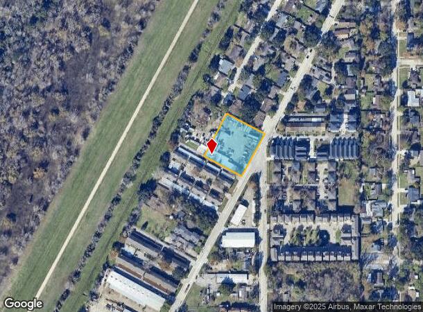
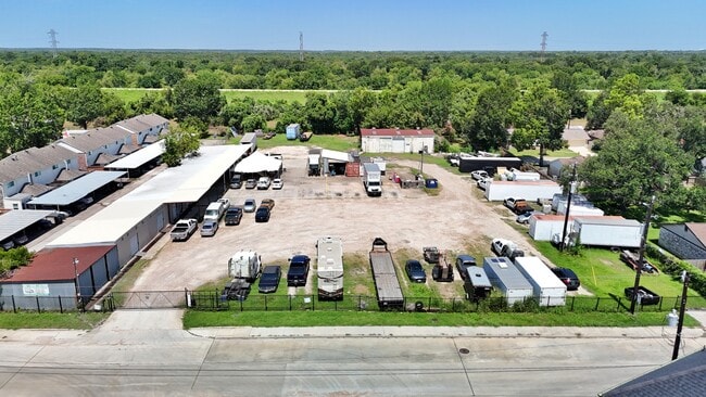
This Property Is For Sale
NEARBY LISTINGS FOR SALE OR LEASE
Property Detail
1915 Sherwood Forest St
0700780070021
Sherwood Estates Sec 3
Shipyard
TR 7A BLK 7 SHERWOOD ESTATES SEC 3
X
Harris
48201C0640M
Texas
2024
1.14 AC
2025
West Outer Loop
543201
Houston
6,000 SF
Houston-The Woodlands-Sugar Land, TX
DEMOGRAPHICS near 1915 Sherwood Forest St
1 Mile
3 Mile
5 Mile
2024 Total Population
5,636
91,036
301,614
2029 Population
6,094
97,720
323,259
Pop Growth 2024-2029
+ 8.13%
+ 7.34%
+ 7.18%
Average Age
36
38
38
2024 Total Households
2,228
34,987
119,238
HH Growth 2024-2029
+ 8.17%
+ 7.60%
+ 7.36%
Median Household Inc
$72,207
$87,017
$78,608
Avg Household Size
2.50
2.50
2.50
2024 Avg HH Vehicles
2.00
2.00
2.00
Median Home Value
$434,967
$454,890
$431,393
Median Year Built
2010
1977
1982
Nearby Places
Map Layers
Map Styles
 Street
 Aerial
- Restaurants
- Banks
- Shops
- Fitness
- Groceries
PUBLIC TRANSPORTATION
AIRPORT
George Bush Intcntl/Houston
DRIVE
WALK
Distance
George Bush Intcntl/Houston
34 min
26.6 mi
William P Hobby
DRIVE
WALK
Distance
William P Hobby
44 min
27.9 mi
Freight Ports
Port of Houston
DRIVE
WALK
Distance
Port of Houston
38 min
24.6 mi
Nearby Properties
Address
Land Use
TOTAL SIZE
Lot Size
Zoning
Address
Land Use
TOTAL SIZE
Lot Size
Zoning
2,976,779 SF
41.36 AC
Address
Land Use
TOTAL SIZE
Lot Size
Zoning
578,530 SF
32.81 AC
Address
Land Use
TOTAL SIZE
Lot Size
Zoning
1,385,616 SF
6.48 AC
Address
Land Use
TOTAL SIZE
Lot Size
Zoning
935,613 SF
27.93 AC
Address
Land Use
TOTAL SIZE
Lot Size
Zoning
797,516 SF
2.91 AC
Address
Land Use
TOTAL SIZE
Lot Size
Zoning
797,509 SF
3.11 AC
Address
Land Use
TOTAL SIZE
Lot Size
Zoning
1,131,022 SF
6.26 AC
Address
Land Use
TOTAL SIZE
Lot Size
Zoning
730,107 SF
2.92 AC
Address
Land Use
TOTAL SIZE
Lot Size
Zoning
1,208,144 SF
6.15 AC
Address
Land Use
TOTAL SIZE
Lot Size
Zoning
730,107 SF
2.57 AC
Address
Land Use
TOTAL SIZE
Lot Size
Zoning
955,731 SF
3.40 AC
Address
Land Use
TOTAL SIZE
Lot Size
Zoning
542,880 SF
1.22 AC
Address
Land Use
TOTAL SIZE
Lot Size
Zoning
487,073 SF
44.12 AC
Address
Land Use
TOTAL SIZE
Lot Size
Zoning
683,397 SF
2.97 AC
Address
Land Use
TOTAL SIZE
Lot Size
Zoning
569,641 SF
5.69 AC
Address
Land Use
TOTAL SIZE
Lot Size
Zoning
306,572 SF
25.46 AC
Address
Land Use
TOTAL SIZE
Lot Size
Zoning
507,014 SF
2.93 AC
Address
Land Use
TOTAL SIZE
Lot Size
Zoning
357,280 SF
1.72 AC
Address
Land Use
TOTAL SIZE
Lot Size
Zoning
656,741 SF
1.88 AC
Address
Land Use
TOTAL SIZE
Lot Size
Zoning
320,534 SF
2.32 AC
Address
Land Use
TOTAL SIZE
Lot Size
Zoning
422,801 SF
12.71 AC
Address
Land Use
TOTAL SIZE
Lot Size
Zoning
520,277 SF
10.04 AC
Address
Land Use
TOTAL SIZE
Lot Size
Zoning
207,841 SF
1.19 AC
Address
Land Use
TOTAL SIZE
Lot Size
Zoning
544,102 SF
2.99 AC
Address
Land Use
TOTAL SIZE
Lot Size
Zoning
199,423 SF
Address
Land Use
TOTAL SIZE
Lot Size
Zoning
519,220 SF
6.23 AC
Address
Land Use
TOTAL SIZE
Lot Size
Zoning
726,444 SF
7.29 AC
Address
Land Use
TOTAL SIZE
Lot Size
Zoning
341,801 SF
9.72 AC
Address
Land Use
TOTAL SIZE
Lot Size
Zoning
533,048 SF
5.80 AC
Address
Land Use
TOTAL SIZE
Lot Size
Zoning
672,183 SF
8.80 AC
The World's #1 Commercial Real Estate Marketplace
Connect with us
© 2025 CoStar Group
The information above has been obtained from sources believed reliable. While we do not doubt its accuracy we have not verified it and make no guarantee, warranty or representation about it. It is your responsibility to independently confirm its accuracy and completeness. Any projections, opinions, assumptions, or estimates used are for example only and do not represent the current or future performance of the property. The value of this transaction to you depends on tax and other factors which should be evaluated by your tax, financial, and legal advisors. You and your advisors should conduct a careful, independent investigation of the property to determine to your satisfaction the suitability of the property for your needs.