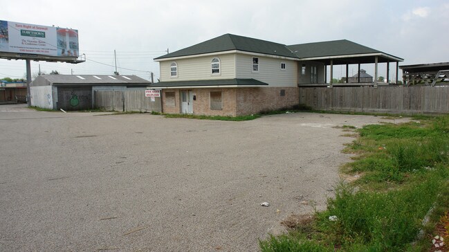
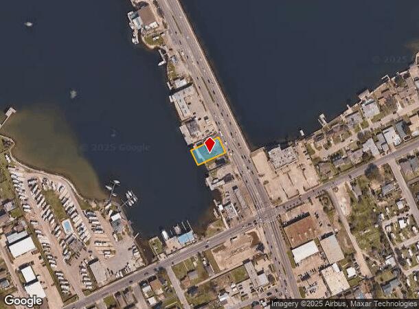
Property Record
1917 61St St, Galveston, TX 77551

NEARBY LISTINGS FOR SALE OR LEASE
Property Detail
1917 61St St
Houston-The Woodlands-Sugar Land, TX
Bartlett Addn (2012) Abst 121
1346-0000-0001-100
BARTLETT ADDN (2012) ABST 121, LOT 1A, ACRES 0.284
Apartment
Galveston
AE
Texas
48167C0439G
1a
2024
0.28 AC
2025
Southeast Outlier
725800
Houston
2,735 SF
DEMOGRAPHICS near 1917 61St St
1 Mile
3 Mile
5 Mile
2024 Total Population
17,233
44,474
59,271
2029 Population
18,256
47,578
63,639
Pop Growth 2024-2029
+ 5.94%
+ 6.98%
+ 7.37%
Average Age
40
41
42
2024 Total Households
6,798
18,517
25,913
HH Growth 2024-2029
+ 6.15%
+ 7.50%
+ 7.92%
Median Household Inc
$53,410
$51,052
$51,875
Avg Household Size
2.30
2.20
2.10
2024 Avg HH Vehicles
2.00
1.00
1.00
Median Home Value
$240,425
$250,735
$275,988
Median Year Built
1974
1970
1971
Nearby Places
Map Layers
Map Styles
 Street
 Aerial
- Restaurants
- Banks
- Shops
- Fitness
- Groceries
PUBLIC TRANSPORTATION
AIRPORT
William P Hobby
DRIVE
WALK
Distance
William P Hobby
54 min
39.2 mi
Freight Ports
Port of Galveston
DRIVE
WALK
Distance
Port of Galveston
4 min
2.2 mi
Nearby Properties
Address
Land Use
TOTAL SIZE
Lot Size
Zoning
Address
Land Use
TOTAL SIZE
Lot Size
Zoning
566,062 SF
40.20 AC
Address
Land Use
TOTAL SIZE
Lot Size
Zoning
1,459,569 SF
11.51 AC
MF1
Address
Land Use
TOTAL SIZE
Lot Size
Zoning
161,300 SF
Address
Land Use
TOTAL SIZE
Lot Size
Zoning
678,840 SF
3.54 AC
R
Address
Land Use
TOTAL SIZE
Lot Size
Zoning
226,301 SF
5.93 AC
I
Address
Land Use
TOTAL SIZE
Lot Size
Zoning
157,959 SF
1.79 AC
Address
Land Use
TOTAL SIZE
Lot Size
Zoning
382,106 SF
24.02 AC
PD
Address
Land Use
TOTAL SIZE
Lot Size
Zoning
228,895 SF
11.41 AC
R
Address
Land Use
TOTAL SIZE
Lot Size
Zoning
153,637 SF
4.52 AC
R
Address
Land Use
TOTAL SIZE
Lot Size
Zoning
169,384 SF
709.59 AC
PD
Address
Land Use
TOTAL SIZE
Lot Size
Zoning
169,052 SF
4.18 AC
R
Address
Land Use
TOTAL SIZE
Lot Size
Zoning
275,380 SF
15.41 AC
PD
Address
Land Use
TOTAL SIZE
Lot Size
Zoning
182,000 SF
41.90 AC
Address
Land Use
TOTAL SIZE
Lot Size
Zoning
Address
Land Use
TOTAL SIZE
Lot Size
Zoning
165,091 SF
Address
Land Use
TOTAL SIZE
Lot Size
Zoning
176,242 SF
2.03 AC
MF2
Address
Land Use
TOTAL SIZE
Lot Size
Zoning
450,048 SF
Address
Land Use
TOTAL SIZE
Lot Size
Zoning
144,000 SF
Address
Land Use
TOTAL SIZE
Lot Size
Zoning
128,906 SF
Address
Land Use
TOTAL SIZE
Lot Size
Zoning
88,994 SF
3.03 AC
R
Address
Land Use
TOTAL SIZE
Lot Size
Zoning
193,003 SF
7.08 AC
C
Address
Land Use
TOTAL SIZE
Lot Size
Zoning
119,996 SF
2.86 AC
Address
Land Use
TOTAL SIZE
Lot Size
Zoning
174,713 SF
6.54 AC
C
Address
Land Use
TOTAL SIZE
Lot Size
Zoning
169,404 SF
7.50 AC
R
Address
Land Use
TOTAL SIZE
Lot Size
Zoning
80,908 SF
0.70 AC
Address
Land Use
TOTAL SIZE
Lot Size
Zoning
131,333 SF
4.80 AC
Address
Land Use
TOTAL SIZE
Lot Size
Zoning
153,210 SF
13.27 AC
R
Address
Land Use
TOTAL SIZE
Lot Size
Zoning
121,734 SF
12.27 AC
IF1
Address
Land Use
TOTAL SIZE
Lot Size
Zoning
136,712 SF
6 AC
C
Address
Land Use
TOTAL SIZE
Lot Size
Zoning
105,544 SF
13.27 AC
PD
The World's #1 Commercial Real Estate Marketplace
Connect with us
© 2025 CoStar Group
The information above has been obtained from sources believed reliable. While we do not doubt its accuracy we have not verified it and make no guarantee, warranty or representation about it. It is your responsibility to independently confirm its accuracy and completeness. Any projections, opinions, assumptions, or estimates used are for example only and do not represent the current or future performance of the property. The value of this transaction to you depends on tax and other factors which should be evaluated by your tax, financial, and legal advisors. You and your advisors should conduct a careful, independent investigation of the property to determine to your satisfaction the suitability of the property for your needs.