Property Record
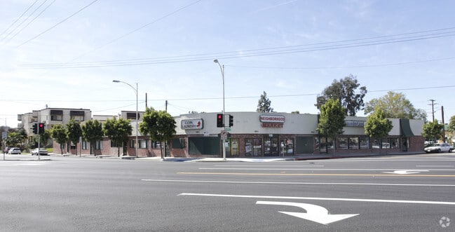
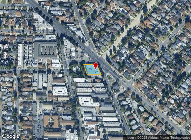
1911 N Glenoaks Blvd, Burbank, CA 91504

NEARBY LISTINGS FOR SALE OR LEASE
Property Detail
1911 N Glenoaks Blvd
Los Angeles-Long Beach-Glendale, CA
3097
2468-005-001
TRACT NO 3097 LOT COM S 89 3140 E 160.93 FT FROM SW COR OF LOT 34 TH S 89 3140 E 149.98 FT TO SE LINE OF SCOTT AVE TH NW THEREON AND W ON S LINE OF PEYTON AVE 244.20 FT TH SE TO BEG PART OF LOT 34
Storesoffices
Los Angeles
X
California
06037C1329F
34
2024
0.34 AC
2025
Burbank
310601
Los Angeles
5,722 SF
DEMOGRAPHICS near 1911 N Glenoaks Blvd
1 Mile
3 Mile
5 Mile
2024 Total Population
23,298
156,676
447,902
2029 Population
22,474
151,355
434,443
Pop Growth 2024-2029
(3.54%)
(3.40%)
(3.00%)
Average Age
41
41
41
2024 Total Households
8,616
57,919
172,710
HH Growth 2024-2029
(3.84%)
(3.67%)
(3.21%)
Median Household Inc
$88,718
$79,718
$76,296
Avg Household Size
2.60
2.60
2.50
2024 Avg HH Vehicles
2.00
2.00
2.00
Median Home Value
$879,569
$839,097
$832,185
Median Year Built
1957
1958
1964
Nearby Places
Map Layers
Map Styles
 Street
 Aerial
- Restaurants
- Banks
- Shops
- Fitness
- Groceries
PUBLIC TRANSPORTATION
COMMUTER RAIL
DRIVE
WALK
Distance
4 min
1.9 mi
Burbank-Bob Hope Airport (Ventura County Line - Southern California Regional Rail Authority (Metrolink))
DRIVE
WALK
Distance
Burbank-Bob Hope Airport (Ventura County Line - Southern California Regional Rail Authority (Metrolink))
6 min
2.2 mi
AIRPORT
Bob Hope
DRIVE
WALK
Distance
Bob Hope
9 min
4.1 mi
Los Angeles International
DRIVE
WALK
Distance
Los Angeles International
43 min
27.7 mi
Long Beach (Daugherty Field)
DRIVE
WALK
Distance
Long Beach (Daugherty Field)
47 min
33.5 mi
Freight Ports
Port of Long Beach
DRIVE
WALK
Distance
Port of Long Beach
49 min
36.3 mi
SALE & LEASE HISTORY
LISTING DATE
SALE/LEASE

Apr 11, 2024
For Sale
Nearby Properties
Address
Land Use
TOTAL SIZE
Lot Size
Zoning
Address
Land Use
TOTAL SIZE
Lot Size
Zoning
735,900 SF
34.87 AC
BUPD*
Address
Land Use
TOTAL SIZE
Lot Size
Zoning
207,766 SF
42.81 AC
BUM1*
Address
Land Use
TOTAL SIZE
Lot Size
Zoning
849,801 SF
59.25 AC
BUM2
Address
Land Use
TOTAL SIZE
Lot Size
Zoning
616,662 SF
19.66 AC
BUM1*
Address
Land Use
TOTAL SIZE
Lot Size
Zoning
489,466 SF
2.90 AC
BUM1
Address
Land Use
TOTAL SIZE
Lot Size
Zoning
452,048 SF
21.58 AC
BCCM
Address
Land Use
TOTAL SIZE
Lot Size
Zoning
43,558 SF
30.11 AC
BUMI-C2*
Address
Land Use
TOTAL SIZE
Lot Size
Zoning
1,328,547 SF
39.36 AC
BUPD
Address
Land Use
TOTAL SIZE
Lot Size
Zoning
432,232 SF
7.17 AC
BUM2
Address
Land Use
TOTAL SIZE
Lot Size
Zoning
219,607 SF
1.51 AC
BUR4
Address
Land Use
TOTAL SIZE
Lot Size
Zoning
380,017 SF
Address
Land Use
TOTAL SIZE
Lot Size
Zoning
362,863 SF
1.82 AC
BUMZ
Address
Land Use
TOTAL SIZE
Lot Size
Zoning
346,186 SF
11.72 AC
BUM2*
Address
Land Use
TOTAL SIZE
Lot Size
Zoning
558,532 SF
5.20 AC
BUC4*
Address
Land Use
TOTAL SIZE
Lot Size
Zoning
660,463 SF
6.88 AC
BUR4*
Address
Land Use
TOTAL SIZE
Lot Size
Zoning
612,976 SF
3.53 AC
BUC2*
Address
Land Use
TOTAL SIZE
Lot Size
Zoning
151,704 SF
1 AC
BUC4*
Address
Land Use
TOTAL SIZE
Lot Size
Zoning
BURAILROAD
Address
Land Use
TOTAL SIZE
Lot Size
Zoning
279,574 SF
4.01 AC
BUM2*
Address
Land Use
TOTAL SIZE
Lot Size
Zoning
299,864 SF
1.29 AC
BUC3
Address
Land Use
TOTAL SIZE
Lot Size
Zoning
252,974 SF
2.86 AC
BUC4
Address
Land Use
TOTAL SIZE
Lot Size
Zoning
126,652 SF
0.93 AC
BUC3
Address
Land Use
TOTAL SIZE
Lot Size
Zoning
106,988 SF
1.45 AC
BUM2*
Address
Land Use
TOTAL SIZE
Lot Size
Zoning
BURAILROAD
Address
Land Use
TOTAL SIZE
Lot Size
Zoning
108,649 SF
3.33 AC
BUPD
Address
Land Use
TOTAL SIZE
Lot Size
Zoning
86,190 SF
3.07 AC
BUM2
Address
Land Use
TOTAL SIZE
Lot Size
Zoning
203,175 SF
1.15 AC
BUC4*
Address
Land Use
TOTAL SIZE
Lot Size
Zoning
255,124 SF
6.14 AC
BUM2-C3*
Address
Land Use
TOTAL SIZE
Lot Size
Zoning
169,740 SF
1.74 AC
BUM2*
The World's #1 Commercial Real Estate Marketplace
Connect with us
© 2025 CoStar Group
The information above has been obtained from sources believed reliable. While we do not doubt its accuracy we have not verified it and make no guarantee, warranty or representation about it. It is your responsibility to independently confirm its accuracy and completeness. Any projections, opinions, assumptions, or estimates used are for example only and do not represent the current or future performance of the property. The value of this transaction to you depends on tax and other factors which should be evaluated by your tax, financial, and legal advisors. You and your advisors should conduct a careful, independent investigation of the property to determine to your satisfaction the suitability of the property for your needs.