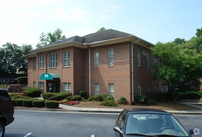
Property Record
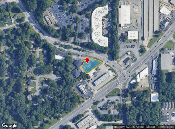
1918 Northlake Pky, Tucker, GA 30084
NEARBY LISTINGS FOR SALE OR LEASE
-
-
-
-
-
-
-
-
-
No Photo
-
-
-
View all Tucker listings for sale on LoopNet.com
Property Detail
1918 Northlake Pky
Atlanta-Sandy Springs-Roswell, GA
Npc Assoc
18-188-02-035
56 X 139 X 234 X 102 X 25 X 113 . . . . . 0.58AC 6-27-94
Officebuilding
DeKalb
X
Georgia
13089C0078K
35
2025
0.58 AC
2025
Northlake/Lavista
021708
Atlanta
7,926 SF
DEMOGRAPHICS near 1918 Northlake Pky
1 Mile
3 Mile
5 Mile
2024 Total Population
7,382
91,532
289,935
2029 Population
7,395
91,150
291,122
Pop Growth 2024-2029
+ 0.18%
(0.42%)
+ 0.41%
Average Age
40
38
37
2024 Total Households
3,120
34,555
112,343
HH Growth 2024-2029
+ 0.19%
(0.42%)
+ 0.39%
Median Household Inc
$81,024
$72,649
$65,059
Avg Household Size
2.40
2.60
2.50
2024 Avg HH Vehicles
2.00
2.00
2.00
Median Home Value
$305,997
$333,490
$336,664
Median Year Built
1976
1975
1979
Nearby Places
- Restaurants
- Banks
- Shops
- Fitness
- Groceries
PUBLIC TRANSPORTATION
AIRPORT
Hartsfield - Jackson Atlanta International
DRIVE
WALK
Distance
Hartsfield - Jackson Atlanta International
33 min
23.3 mi
SALE & LEASE HISTORY
LISTING DATE
SALE/LEASE

Sep 21, 2020
For Sale
Oct 13, 2022
For Sale
Nearby Properties
Address
Land Use
TOTAL SIZE
Lot Size
Zoning
Address
Land Use
TOTAL SIZE
Lot Size
Zoning
377,506 SF
8.70 AC
X
Address
Land Use
TOTAL SIZE
Lot Size
Zoning
208,608 SF
20.89 AC
OI: OFFICE
Address
Land Use
TOTAL SIZE
Lot Size
Zoning
819,703 SF
55.80 AC
M
Address
Land Use
TOTAL SIZE
Lot Size
Zoning
503,480 SF
50.04 AC
RM150
Address
Land Use
TOTAL SIZE
Lot Size
Zoning
228,504 SF
15.57 AC
M
Address
Land Use
TOTAL SIZE
Lot Size
Zoning
70,929 SF
6.64 AC
C1: LOCAL
Address
Land Use
TOTAL SIZE
Lot Size
Zoning
355,421 SF
7.03 AC
X
Address
Land Use
TOTAL SIZE
Lot Size
Zoning
185,066 SF
25.53 AC
O-1
Address
Land Use
TOTAL SIZE
Lot Size
Zoning
313,420 SF
12.74 AC
X
Address
Land Use
TOTAL SIZE
Lot Size
Zoning
587,493 SF
29.79 AC
X
Address
Land Use
TOTAL SIZE
Lot Size
Zoning
222,799 SF
11.59 AC
X
Address
Land Use
TOTAL SIZE
Lot Size
Zoning
213,410 SF
20.68 AC
O-1
Address
Land Use
TOTAL SIZE
Lot Size
Zoning
169,005 SF
11.81 AC
O-1
Address
Land Use
TOTAL SIZE
Lot Size
Zoning
180,586 SF
8.70 AC
X
Address
Land Use
TOTAL SIZE
Lot Size
Zoning
385,221 SF
27.41 AC
RM85
Address
Land Use
TOTAL SIZE
Lot Size
Zoning
166,174 SF
19.70 AC
RM85
Address
Land Use
TOTAL SIZE
Lot Size
Zoning
89,362 SF
13.99 AC
M
Address
Land Use
TOTAL SIZE
Lot Size
Zoning
337,746 SF
29.94 AC
RM100
Address
Land Use
TOTAL SIZE
Lot Size
Zoning
170,933 SF
15.39 AC
X
Address
Land Use
TOTAL SIZE
Lot Size
Zoning
319,984 SF
24.70 AC
RM100
Address
Land Use
TOTAL SIZE
Lot Size
Zoning
158,068 SF
9.21 AC
X
Address
Land Use
TOTAL SIZE
Lot Size
Zoning
269,639 SF
24.65 AC
RM100
Address
Land Use
TOTAL SIZE
Lot Size
Zoning
480,302 SF
34.46 AC
RM85
Address
Land Use
TOTAL SIZE
Lot Size
Zoning
299,798 SF
17.20 AC
X
Address
Land Use
TOTAL SIZE
Lot Size
Zoning
240,276 SF
19.53 AC
RM85
Address
Land Use
TOTAL SIZE
Lot Size
Zoning
188,550 SF
15.40 AC
C1
Address
Land Use
TOTAL SIZE
Lot Size
Zoning
121,320 SF
13.77 AC
OI
Address
Land Use
TOTAL SIZE
Lot Size
Zoning
273,192 SF
24.07 AC
RM100
Address
Land Use
TOTAL SIZE
Lot Size
Zoning
189,486 SF
18.57 AC
X
Address
Land Use
TOTAL SIZE
Lot Size
Zoning
490,343 SF
28.70 AC
X
The World's #1 Commercial Real Estate Marketplace
Connect with us
© 2025 CoStar Group
The information above has been obtained from sources believed reliable. While we do not doubt its accuracy we have not verified it and make no guarantee, warranty or representation about it. It is your responsibility to independently confirm its accuracy and completeness. Any projections, opinions, assumptions, or estimates used are for example only and do not represent the current or future performance of the property. The value of this transaction to you depends on tax and other factors which should be evaluated by your tax, financial, and legal advisors. You and your advisors should conduct a careful, independent investigation of the property to determine to your satisfaction the suitability of the property for your needs.