Property Record
1919 E 2Nd St, Edmond, OK 73034
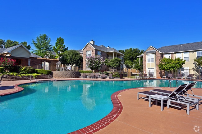


Property Detail
1919 E 2Nd St
Oklahoma City, OK
UNPLTD PT SEC 30 14N 2W 000 000 PT SW4 SEC 30 14N 2W BEG 806FT E & 270FT N OF SW/C SW4 TH N630.65FT W146FT N420FT E989.14FT S1322.18FT W164.26FT N308FT W329.88FT N457FT W15FT N25FT W139FT SW27.99FT W23FT S19FT W5FT S215FT E153FT S210FT W172FT S60FT W
189236000
Oklahoma
Multifamilydwelling
Oklahoma
AE The base floodplain where base flood elevations are provided. AE Zones are now used on new format FIRMs instead of A1-A30 Zones.
4,13
2024
21.61 AC
2025
Edmond
108114
Oklahoma City
304,744 SF
NEARBY LISTINGS FOR SALE OR LEASE
-
-
View all Edmond listings for sale on LoopNet.com
DEMOGRAPHICS near 1919 E 2Nd St
1 mile
3 mile
5 mile
2025 Total Population
9,309
62,567
121,027
2030 Population
9,402
63,426
122,964
Pop Growth 2025-2030
+ 1.00%
+ 1.37%
+ 1.60%
Average Age
35
39
39
2025 Total Households
4,025
25,049
46,487
HH Growth 2025-2030
+ 1.09%
+ 1.50%
+ 1.70%
Median Household Inc
$75,610
$92,407
$103,608
Avg Household Size
2.20
2.40
2.50
2025 Avg HH Vehicles
2.00
2.00
2.00
Median Home Value
$340,545
$331,842
$353,163
Median Year Built
1989
1988
1994
Nearby Places
Map Layers
Map Styles
 Street
 Aerial
Transit
 Traffic
 Biking
Places
Listings with unknown addresses are not visible on the map
- Restaurants
- Banks
- Shops
- Fitness
- Groceries
PUBLIC TRANSPORTATION
AIRPORT
Will Rogers World
Drive
Walk
Distance
Will Rogers World
41 min
24.2 mi
Freight Ports
Tulsa Port Of Catoosa
Drive
Walk
Distance
Tulsa Port Of Catoosa
129 min
118.0 mi
Nearby Properties
Address
Land Use
TOTAL SIZE
Lot Size
Zoning
Address
Land Use
TOTAL SIZE
Lot Size
Zoning
200,545 SF
24.93 AC
Address
Land Use
TOTAL SIZE
Lot Size
Zoning
280,581 SF
28.90 AC
Address
Land Use
TOTAL SIZE
Lot Size
Zoning
304,750 SF
21.76 AC
Address
Land Use
TOTAL SIZE
Lot Size
Zoning
289,309 SF
26.01 AC
Address
Land Use
TOTAL SIZE
Lot Size
Zoning
371,968 SF
30.50 AC
Address
Land Use
TOTAL SIZE
Lot Size
Zoning
402,880 SF
15.39 AC
Address
Land Use
TOTAL SIZE
Lot Size
Zoning
164,940 SF
27.04 AC
Address
Land Use
TOTAL SIZE
Lot Size
Zoning
242,196 SF
14.07 AC
Address
Land Use
TOTAL SIZE
Lot Size
Zoning
265,194 SF
13.67 AC
Address
Land Use
TOTAL SIZE
Lot Size
Zoning
221,364 SF
12.09 AC
Address
Land Use
TOTAL SIZE
Lot Size
Zoning
147,080 SF
10.38 AC
Address
Land Use
TOTAL SIZE
Lot Size
Zoning
82,162 SF
6.13 AC
Address
Land Use
TOTAL SIZE
Lot Size
Zoning
167,664 SF
14.14 AC
Address
Land Use
TOTAL SIZE
Lot Size
Zoning
173,384 SF
5.51 AC
Address
Land Use
TOTAL SIZE
Lot Size
Zoning
99,783 SF
16.78 AC
Address
Land Use
TOTAL SIZE
Lot Size
Zoning
8,976 SF
1.14 AC
Address
Land Use
TOTAL SIZE
Lot Size
Zoning
6,636 SF
0.18 AC
Address
Land Use
TOTAL SIZE
Lot Size
Zoning
132,226 SF
11.89 AC
Address
Land Use
TOTAL SIZE
Lot Size
Zoning
64,296 SF
8.43 AC
Address
Land Use
TOTAL SIZE
Lot Size
Zoning
72,273 SF
6.58 AC
Address
Land Use
TOTAL SIZE
Lot Size
Zoning
7,428 SF
1 AC
Address
Land Use
TOTAL SIZE
Lot Size
Zoning
176,307 SF
14.76 AC
Address
Land Use
TOTAL SIZE
Lot Size
Zoning
8,760 SF
1.05 AC
Address
Land Use
TOTAL SIZE
Lot Size
Zoning
197,818 SF
28.97 AC
Address
Land Use
TOTAL SIZE
Lot Size
Zoning
140,000 SF
11.94 AC
Address
Land Use
TOTAL SIZE
Lot Size
Zoning
8,920 SF
7.83 AC
Address
Land Use
TOTAL SIZE
Lot Size
Zoning
28,150 SF
4.81 AC
Address
Land Use
TOTAL SIZE
Lot Size
Zoning
140,928 SF
9.60 AC
Address
Land Use
TOTAL SIZE
Lot Size
Zoning
71,902 SF
6.68 AC
The World's #1 Commercial Real Estate Marketplace
Connect with us
© 2026 CoStar Group
The information above has been obtained from sources believed reliable. While we do not doubt its accuracy we have not verified it and make no guarantee, warranty or representation about it. It is your responsibility to independently confirm its accuracy and completeness. Any projections, opinions, assumptions, or estimates used are for example only and do not represent the current or future performance of the property. The value of this transaction to you depends on tax and other factors which should be evaluated by your tax, financial, and legal advisors. You and your advisors should conduct a careful, independent investigation of the property to determine to your satisfaction the suitability of the property for your needs.