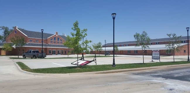
Property Record
1919 N 2Nd Ave, Canyon, TX 79015

Property Detail
1919 N 2Nd Ave
Amarillo, TX
DEPOT ADDN # 1, LOT 002, BLK 0003, 2.3300 ACRES
R-014-0700-0010-0
RANDALL
Officebuilding
Texas
B and X Area of moderate flood hazard, usually the area between the limits of the 100-year and 500-year floods.
2
2024
2.33 AC
2025
Amarillo
021803
Other Market Areas
25,315 SF
NEARBY LISTINGS FOR SALE OR LEASE
DEMOGRAPHICS near 1919 N 2Nd Ave
1 mile
3 mile
5 mile
2025 Total Population
9,321
18,138
25,292
2030 Population
9,827
19,205
26,908
Pop Growth 2025-2030
+ 5.43%
+ 5.88%
+ 6.39%
Average Age
34
35
37
2025 Total Households
3,617
6,955
9,520
HH Growth 2025-2030
+ 5.58%
+ 5.92%
+ 6.36%
Median Household Inc
$60,203
$71,038
$79,144
Avg Household Size
2.20
2.40
2.50
2025 Avg HH Vehicles
2.00
2.00
2.00
Median Home Value
$242,368
$257,829
$285,246
Median Year Built
1976
1981
1985
Nearby Places
Map Layers
Map Styles
 Street
 Aerial
Transit
 Traffic
 Biking
Places
Listings with unknown addresses are not visible on the map
- Restaurants
- Banks
- Shops
- Fitness
- Groceries
PUBLIC TRANSPORTATION
AIRPORT
Rick Husband Amarillo International
Drive
Walk
Distance
Rick Husband Amarillo International
33 min
25.2 mi
Freight Ports
Tulsa Port Of Catoosa
Drive
Walk
Distance
Tulsa Port Of Catoosa
415 min
393.2 mi
SALE & LEASE HISTORY
LISTING DATE
SALE/LEASE

May 31, 2019
For Lease
Nearby Properties
Address
Land Use
TOTAL SIZE
Lot Size
Zoning
Address
Land Use
TOTAL SIZE
Lot Size
Zoning
250,419 SF
38.53 AC
Address
Land Use
TOTAL SIZE
Lot Size
Zoning
199,802 SF
72.40 AC
PD
Address
Land Use
TOTAL SIZE
Lot Size
Zoning
83,276 SF
12.08 AC
Address
Land Use
TOTAL SIZE
Lot Size
Zoning
68,108 SF
7.06 AC
RC2
Address
Land Use
TOTAL SIZE
Lot Size
Zoning
54,250 SF
17.94 AC
PD
Address
Land Use
TOTAL SIZE
Lot Size
Zoning
86,149 SF
15 AC
Address
Land Use
TOTAL SIZE
Lot Size
Zoning
173,234 SF
13.27 AC
SFS
Address
Land Use
TOTAL SIZE
Lot Size
Zoning
50,184 SF
0.39 AC
RC3
Address
Land Use
TOTAL SIZE
Lot Size
Zoning
202,414 SF
8.84 AC
Address
Land Use
TOTAL SIZE
Lot Size
Zoning
127,080 SF
6.30 AC
2F
Address
Land Use
TOTAL SIZE
Lot Size
Zoning
102,413 SF
18.79 AC
SFSRC
Address
Land Use
TOTAL SIZE
Lot Size
Zoning
42,871 SF
49.77 AC
Address
Land Use
TOTAL SIZE
Lot Size
Zoning
157,836 SF
22.06 AC
RC2
Address
Land Use
TOTAL SIZE
Lot Size
Zoning
56,927 SF
9.81 AC
SFS
Address
Land Use
TOTAL SIZE
Lot Size
Zoning
71,346 SF
2.06 AC
RC3
Address
Land Use
TOTAL SIZE
Lot Size
Zoning
116,013 SF
15.13 AC
Address
Land Use
TOTAL SIZE
Lot Size
Zoning
52,095 SF
9.60 AC
PD
Address
Land Use
TOTAL SIZE
Lot Size
Zoning
48,470 SF
11.63 AC
Address
Land Use
TOTAL SIZE
Lot Size
Zoning
60,493 SF
3.15 AC
Address
Land Use
TOTAL SIZE
Lot Size
Zoning
32,966 SF
6.03 AC
Address
Land Use
TOTAL SIZE
Lot Size
Zoning
41,311 SF
2.84 AC
SFS
Address
Land Use
TOTAL SIZE
Lot Size
Zoning
38,030 SF
5.43 AC
SFA
Address
Land Use
TOTAL SIZE
Lot Size
Zoning
28,748 SF
0.96 AC
RC3
Address
Land Use
TOTAL SIZE
Lot Size
Zoning
35,046 SF
2.93 AC
Address
Land Use
TOTAL SIZE
Lot Size
Zoning
94,223 SF
4.71 AC
RC2
Address
Land Use
TOTAL SIZE
Lot Size
Zoning
36,606 SF
4.23 AC
C
Address
Land Use
TOTAL SIZE
Lot Size
Zoning
72,010 SF
3.94 AC
Address
Land Use
TOTAL SIZE
Lot Size
Zoning
38,982 SF
3.31 AC
SFE
The World's #1 Commercial Real Estate Marketplace
Connect with us
© 2026 CoStar Group
The information above has been obtained from sources believed reliable. While we do not doubt its accuracy we have not verified it and make no guarantee, warranty or representation about it. It is your responsibility to independently confirm its accuracy and completeness. Any projections, opinions, assumptions, or estimates used are for example only and do not represent the current or future performance of the property. The value of this transaction to you depends on tax and other factors which should be evaluated by your tax, financial, and legal advisors. You and your advisors should conduct a careful, independent investigation of the property to determine to your satisfaction the suitability of the property for your needs.