Property Record
1919 Rolling Hills Ln, Winchester, KY 40391


Save to a Folder
{{folder.Name}}
{{folder.ListingIds.length}} Properties
{{folder.ListingIds.length}} Property
Create a New Folder
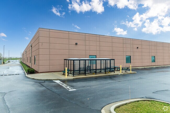
Property Detail
1919 Rolling Hills Ln
Lexington-Fayette, KY
TRACT 607 PLAT 1830
053-0000-00310
Clark
Commercialnec
Kentucky
B and X Area of moderate flood hazard, usually the area between the limits of the 100-year and 500-year floods.
15.42 AC
0
Clark County
2025
Lexington/Fayette
020201
NEARBY LISTINGS FOR SALE OR LEASE
DEMOGRAPHICS near 1919 Rolling Hills Ln
1 mile
3 mile
5 mile
2025 Total Population
1,528
24,657
30,552
2030 Population
1,552
25,304
31,266
Pop Growth 2025-2030
+ 1.57%
+ 2.62%
+ 2.34%
Average Age
39
40
41
2025 Total Households
691
10,142
12,465
HH Growth 2025-2030
+ 1.74%
+ 2.65%
+ 2.37%
Median Household Inc
$49,999
$62,365
$65,275
Avg Household Size
2.20
2.40
2.40
2025 Avg HH Vehicles
2.00
2.00
2.00
Median Home Value
$155,384
$195,390
$204,284
Median Year Built
1972
1978
1981
Nearby Places
Map Layers
Map Styles
 Street
 Aerial
Layers
 Traffic
 Biking
Places
Listings with unknown addresses are not visible on the map
- Restaurants
- Banks
- Shops
- Fitness
- Groceries
PUBLIC TRANSPORTATION
AIRPORT
Blue Grass
Drive
Walk
Distance
Blue Grass
39 min
27.5 mi
Freight Ports
Port of Toledo
Drive
Walk
Distance
Port of Toledo
347 min
300.8 mi
SALE & LEASE HISTORY
LISTING DATE
SALE/LEASE

Apr 07, 2023
For Lease
Nearby Properties
Address
Land Use
TOTAL SIZE
Lot Size
Zoning
Address
Land Use
TOTAL SIZE
Lot Size
Zoning
45,000 SF
30.26 AC
AGRICULTUR
Address
Land Use
TOTAL SIZE
Lot Size
Zoning
423,158 SF
36.32 AC
LIGHT INDU
Address
Land Use
TOTAL SIZE
Lot Size
Zoning
127.39 AC
Address
Land Use
TOTAL SIZE
Lot Size
Zoning
Address
Land Use
TOTAL SIZE
Lot Size
Zoning
792 SF
5.71 AC
SINGLE FAM
Address
Land Use
TOTAL SIZE
Lot Size
Zoning
Address
Land Use
TOTAL SIZE
Lot Size
Zoning
Address
Land Use
TOTAL SIZE
Lot Size
Zoning
Address
Land Use
TOTAL SIZE
Lot Size
Zoning
Address
Land Use
TOTAL SIZE
Lot Size
Zoning
179,856 SF
20.42 AC
PLANNED DE
Address
Land Use
TOTAL SIZE
Lot Size
Zoning
60,726 SF
14.59 AC
Address
Land Use
TOTAL SIZE
Lot Size
Zoning
136,116 SF
12.58 AC
LIGHT INDU
Address
Land Use
TOTAL SIZE
Lot Size
Zoning
698,666 SF
44.85 AC
LIGHT INDU
Address
Land Use
TOTAL SIZE
Lot Size
Zoning
6.65 AC
I1
Address
Land Use
TOTAL SIZE
Lot Size
Zoning
6.50 AC
PD
Address
Land Use
TOTAL SIZE
Lot Size
Zoning
0.98 AC
DOWNTOWN B
Address
Land Use
TOTAL SIZE
Lot Size
Zoning
17.86 AC
I1
Address
Land Use
TOTAL SIZE
Lot Size
Zoning
24.23 AC
I1
Address
Land Use
TOTAL SIZE
Lot Size
Zoning
121,809 SF
19.44 AC
LIGHT INDU
Address
Land Use
TOTAL SIZE
Lot Size
Zoning
Address
Land Use
TOTAL SIZE
Lot Size
Zoning
76,440 SF
15.67 AC
PLANNED DE
Address
Land Use
TOTAL SIZE
Lot Size
Zoning
4.53 AC
Address
Land Use
TOTAL SIZE
Lot Size
Zoning
64,000 SF
8.45 AC
HIGHWAY BU
Address
Land Use
TOTAL SIZE
Lot Size
Zoning
3.15 AC
Address
Land Use
TOTAL SIZE
Lot Size
Zoning
60,060 SF
6.04 AC
HIGHWAY BU
Address
Land Use
TOTAL SIZE
Lot Size
Zoning
15.06 AC
I1
Address
Land Use
TOTAL SIZE
Lot Size
Zoning
5.88 AC
PLANNED DE
Address
Land Use
TOTAL SIZE
Lot Size
Zoning
3.59 AC
I1
Address
Land Use
TOTAL SIZE
Lot Size
Zoning
The World's #1 Commercial Real Estate Marketplace
Connect with us
© 2026 CoStar Group
The information above has been obtained from sources believed reliable. While we do not doubt its accuracy we have not verified it and make no guarantee, warranty or representation about it. It is your responsibility to independently confirm its accuracy and completeness. Any projections, opinions, assumptions, or estimates used are for example only and do not represent the current or future performance of the property. The value of this transaction to you depends on tax and other factors which should be evaluated by your tax, financial, and legal advisors. You and your advisors should conduct a careful, independent investigation of the property to determine to your satisfaction the suitability of the property for your needs.