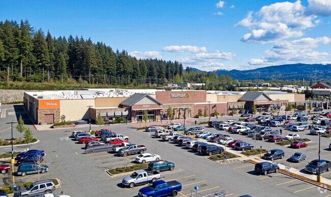
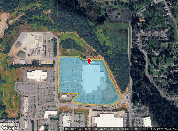
Property Record
19191 N Kelsey St, Monroe, WA 98272
NEARBY LISTINGS FOR SALE OR LEASE
Property Detail
19191 N Kelsey St
280636-004-036-00
SECTION 36 TOWNSHIP 28 RANGE 06 QUARTER SE NEW LOT 1 CITY MON BSP REC AFN 201507215004 & AMEND REC AFN 201605045006 BEING PTN E1/2 SE SD SEC
Storebuilding
Snohomish
X
Washington
53061C1376G
1
2024
17.30 AC
2025
S Snohomish County
052203
Seattle/Puget Sound
156,220 SF
Seattle-Tacoma-Bellevue, WA
DEMOGRAPHICS near 19191 N Kelsey St
1 Mile
3 Mile
5 Mile
2024 Total Population
8,928
28,314
37,809
2029 Population
9,462
29,668
39,466
Pop Growth 2024-2029
+ 5.98%
+ 4.78%
+ 4.38%
Average Age
36
38
39
2024 Total Households
3,136
9,006
12,273
HH Growth 2024-2029
+ 6.12%
+ 5.07%
+ 4.58%
Median Household Inc
$92,449
$108,248
$114,739
Avg Household Size
2.80
2.80
2.80
2024 Avg HH Vehicles
2.00
2.00
2.00
Median Home Value
$601,844
$611,210
$660,477
Median Year Built
1998
1995
1993
Nearby Places
Map Layers
Map Styles
 Street
 Aerial
- Restaurants
- Banks
- Shops
- Fitness
- Groceries
PUBLIC TRANSPORTATION
AIRPORT
Seattle Paine Field International
DRIVE
WALK
Distance
Seattle Paine Field International
35 min
24.1 mi
Freight Ports
Port of Everett
DRIVE
WALK
Distance
Port of Everett
25 min
16.5 mi
Nearby Properties
Address
Land Use
TOTAL SIZE
Lot Size
Zoning
Address
Land Use
TOTAL SIZE
Lot Size
Zoning
595.90 AC
PS
Address
Land Use
TOTAL SIZE
Lot Size
Zoning
41,232 SF
88.74 AC
GC
Address
Land Use
TOTAL SIZE
Lot Size
Zoning
381,991 SF
10.41 AC
MR6000
Address
Land Use
TOTAL SIZE
Lot Size
Zoning
263,812 SF
12.64 AC
LI
Address
Land Use
TOTAL SIZE
Lot Size
Zoning
142,629 SF
8.76 AC
DC
Address
Land Use
TOTAL SIZE
Lot Size
Zoning
9.80 AC
PO
Address
Land Use
TOTAL SIZE
Lot Size
Zoning
79.16 AC
PS
Address
Land Use
TOTAL SIZE
Lot Size
Zoning
108,120 SF
10.33 AC
MR6000
Address
Land Use
TOTAL SIZE
Lot Size
Zoning
153,578 SF
5.56 AC
LI
Address
Land Use
TOTAL SIZE
Lot Size
Zoning
47,357 SF
6.82 AC
LI
Address
Land Use
TOTAL SIZE
Lot Size
Zoning
3,720 SF
46.72 AC
GC
Address
Land Use
TOTAL SIZE
Lot Size
Zoning
139,412 SF
7.08 AC
GC
Address
Land Use
TOTAL SIZE
Lot Size
Zoning
95,685 SF
4.92 AC
LI
Address
Land Use
TOTAL SIZE
Lot Size
Zoning
53,521 SF
10.09 AC
R-5
Address
Land Use
TOTAL SIZE
Lot Size
Zoning
85,045 SF
2.87 AC
UR6000
Address
Land Use
TOTAL SIZE
Lot Size
Zoning
41,896 SF
5 AC
GC
Address
Land Use
TOTAL SIZE
Lot Size
Zoning
49,401 SF
1.69 AC
PO
Address
Land Use
TOTAL SIZE
Lot Size
Zoning
44,337 SF
4.81 AC
LI
Address
Land Use
TOTAL SIZE
Lot Size
Zoning
76,010 SF
3.59 AC
LI
Address
Land Use
TOTAL SIZE
Lot Size
Zoning
75,922 SF
3.31 AC
LI
Address
Land Use
TOTAL SIZE
Lot Size
Zoning
12.07 AC
PS
Address
Land Use
TOTAL SIZE
Lot Size
Zoning
61,900 SF
4.06 AC
GC
Address
Land Use
TOTAL SIZE
Lot Size
Zoning
65,999 SF
3.55 AC
LI
Address
Land Use
TOTAL SIZE
Lot Size
Zoning
80,800 SF
4.26 AC
LI
Address
Land Use
TOTAL SIZE
Lot Size
Zoning
45,434 SF
2.36 AC
MUC
Address
Land Use
TOTAL SIZE
Lot Size
Zoning
45,504 SF
2.67 AC
SC
Address
Land Use
TOTAL SIZE
Lot Size
Zoning
67,200 SF
3.78 AC
LI
Address
Land Use
TOTAL SIZE
Lot Size
Zoning
38,040 SF
1.74 AC
GC
Address
Land Use
TOTAL SIZE
Lot Size
Zoning
62,562 SF
3.14 AC
LI
The World's #1 Commercial Real Estate Marketplace
Connect with us
© 2026 CoStar Group
The information above has been obtained from sources believed reliable. While we do not doubt its accuracy we have not verified it and make no guarantee, warranty or representation about it. It is your responsibility to independently confirm its accuracy and completeness. Any projections, opinions, assumptions, or estimates used are for example only and do not represent the current or future performance of the property. The value of this transaction to you depends on tax and other factors which should be evaluated by your tax, financial, and legal advisors. You and your advisors should conduct a careful, independent investigation of the property to determine to your satisfaction the suitability of the property for your needs.