Property Record
192 Broom Straw Rd, Chapin, SC 29036


NEARBY LISTINGS FOR SALE OR LEASE
Property Detail
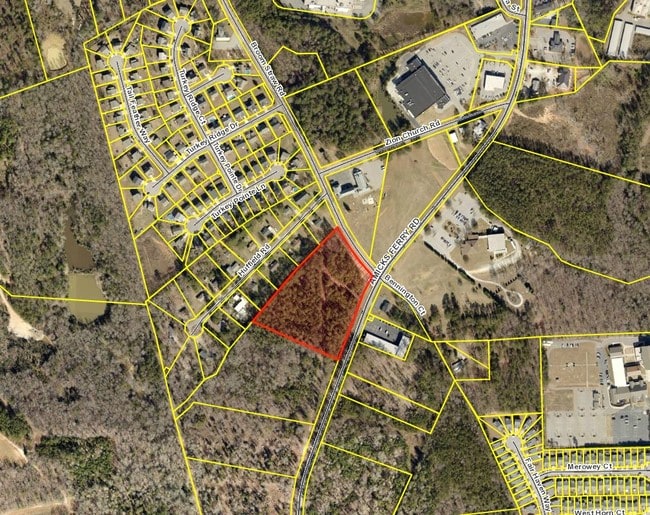
192 Broom Straw Rd
000700-09-012
Plat Prepared For Robert E Wilder
Medicalbuilding
WESTERN PORTION PARCEL 2
X
Lexington
45063C0040J
South Carolina
2025
5.08 AC
2024
Dutch Fork/Irmo
021208
Columbia
8,523 SF
Columbia, SC
DEMOGRAPHICS near 192 Broom Straw Rd
1 mile
3 mile
5 mile
2024 Total Population
1,743
8,999
22,385
2029 Population
1,888
9,800
24,156
Pop Growth 2024-2029
+ 8.32%
+ 8.90%
+ 7.91%
Average Age
39
40
42
2024 Total Households
680
3,388
8,547
HH Growth 2024-2029
+ 8.38%
+ 9.00%
+ 8.05%
Median Household Inc
$66,428
$70,795
$89,659
Avg Household Size
2.60
2.60
2.60
2024 Avg HH Vehicles
2.00
2.00
2.00
Median Home Value
$196,603
$247,747
$297,297
Median Year Built
2001
1999
1999
Nearby Places
Map Layers
Map Styles
 Street
 Aerial
Transit
 Traffic
 Biking
Places
Listings with unknown addresses are not visible on the map
- Restaurants
- Banks
- Shops
- Fitness
- Groceries
PUBLIC TRANSPORTATION
AIRPORT
Columbia Metro
Drive
Walk
Distance
Columbia Metro
45 min
28.7 mi
Freight Ports
North Charleston Terminal
Drive
Walk
Distance
North Charleston Terminal
144 min
125.0 mi
SALE & LEASE HISTORY
LISTING DATE
SALE/LEASE

Sep 24, 2016
For Sale
Jun 09, 2017
For Sale
Feb 22, 2021
For Sale
Feb 01, 2017
For Sale
Nearby Properties
Address
Land Use
TOTAL SIZE
Lot Size
Zoning
Address
Land Use
TOTAL SIZE
Lot Size
Zoning
Address
Land Use
TOTAL SIZE
Lot Size
Zoning
87.84 AC
Address
Land Use
TOTAL SIZE
Lot Size
Zoning
4,824 SF
4.28 AC
RU
Address
Land Use
TOTAL SIZE
Lot Size
Zoning
46,031 SF
12.16 AC
GC
Address
Land Use
TOTAL SIZE
Lot Size
Zoning
88 AC
RU
Address
Land Use
TOTAL SIZE
Lot Size
Zoning
6,368 SF
12 AC
RU
Address
Land Use
TOTAL SIZE
Lot Size
Zoning
4,181 SF
11.12 AC
RU
Address
Land Use
TOTAL SIZE
Lot Size
Zoning
2,638 SF
0.19 AC
PDD
Address
Land Use
TOTAL SIZE
Lot Size
Zoning
3,493 SF
3.08 AC
RU
Address
Land Use
TOTAL SIZE
Lot Size
Zoning
61,972 SF
7.82 AC
GC
Address
Land Use
TOTAL SIZE
Lot Size
Zoning
2,527 SF
0.18 AC
PDD
Address
Land Use
TOTAL SIZE
Lot Size
Zoning
2,174 SF
0.18 AC
PDD
Address
Land Use
TOTAL SIZE
Lot Size
Zoning
2,130 SF
0.20 AC
PDD
Address
Land Use
TOTAL SIZE
Lot Size
Zoning
2,180 SF
0.16 AC
PDD
Address
Land Use
TOTAL SIZE
Lot Size
Zoning
2,220 SF
0.18 AC
PDD
Address
Land Use
TOTAL SIZE
Lot Size
Zoning
2,659 SF
0.29 AC
PDD
Address
Land Use
TOTAL SIZE
Lot Size
Zoning
2,180 SF
0.23 AC
PDD
Address
Land Use
TOTAL SIZE
Lot Size
Zoning
2,032 SF
0.18 AC
PDD
Address
Land Use
TOTAL SIZE
Lot Size
Zoning
2,152 SF
0.23 AC
PDD
Address
Land Use
TOTAL SIZE
Lot Size
Zoning
2,032 SF
0.24 AC
PDD
Address
Land Use
TOTAL SIZE
Lot Size
Zoning
2,247 SF
0.22 AC
PDD
Address
Land Use
TOTAL SIZE
Lot Size
Zoning
1,911 SF
0.17 AC
PDD
Address
Land Use
TOTAL SIZE
Lot Size
Zoning
2,890 SF
3 AC
RU
Address
Land Use
TOTAL SIZE
Lot Size
Zoning
2,199 SF
0.16 AC
PDD
Address
Land Use
TOTAL SIZE
Lot Size
Zoning
3,196 SF
4.28 AC
RU
Address
Land Use
TOTAL SIZE
Lot Size
Zoning
1,709 SF
0.20 AC
PDD
Address
Land Use
TOTAL SIZE
Lot Size
Zoning
1,911 SF
0.17 AC
PDD
Address
Land Use
TOTAL SIZE
Lot Size
Zoning
24.64 AC
Address
Land Use
TOTAL SIZE
Lot Size
Zoning
1,484 SF
18.14 AC
Address
Land Use
TOTAL SIZE
Lot Size
Zoning
1,911 SF
0.19 AC
PDD
The World's #1 Commercial Real Estate Marketplace
Connect with us
© 2026 CoStar Group
The information above has been obtained from sources believed reliable. While we do not doubt its accuracy we have not verified it and make no guarantee, warranty or representation about it. It is your responsibility to independently confirm its accuracy and completeness. Any projections, opinions, assumptions, or estimates used are for example only and do not represent the current or future performance of the property. The value of this transaction to you depends on tax and other factors which should be evaluated by your tax, financial, and legal advisors. You and your advisors should conduct a careful, independent investigation of the property to determine to your satisfaction the suitability of the property for your needs.