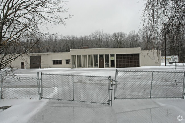
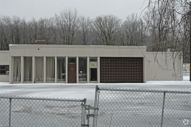
Property Record
192 Plains Rd, Walden, NY 12586

Property Detail
192 Plains Rd
334289-003-000-0001-046.100-0000
Orange
Industrialgeneral
New York
RA-.5
46.10
B and X Area of moderate flood hazard, usually the area between the limits of the 100-year and 500-year floods.
16.10 AC
2024
Orange County
2024
Northern New Jersey
010602
Kiryas Joel-Poughkeepsie-Newburgh, NY
21,221 SF
NEARBY LISTINGS FOR SALE OR LEASE
DEMOGRAPHICS near 192 Plains Rd
1 mile
3 mile
5 mile
2025 Total Population
1,103
12,748
36,285
2030 Population
1,102
12,796
36,650
Pop Growth 2025-2030
(0.09%)
+ 0.38%
+ 1.01%
Average Age
42
41
41
2025 Total Households
411
4,405
12,604
HH Growth 2025-2030
0.00%
+ 0.34%
+ 1.03%
Median Household Inc
$119,999
$100,444
$104,047
Avg Household Size
2.70
2.70
2.70
2025 Avg HH Vehicles
2.00
2.00
2.00
Median Home Value
$382,583
$390,657
$368,166
Median Year Built
1977
1972
1976
Nearby Places
Map Layers
Map Styles
 Street
 Aerial
Transit
 Traffic
 Biking
Places
Listings with unknown addresses are not visible on the map
- Restaurants
- Banks
- Shops
- Fitness
- Groceries
PUBLIC TRANSPORTATION
AIRPORT
New York Stewart International
Drive
Walk
Distance
New York Stewart International
20 min
9.5 mi
Nearby Properties
Address
Land Use
TOTAL SIZE
Lot Size
Zoning
Address
Land Use
TOTAL SIZE
Lot Size
Zoning
109,108 SF
15.60 AC
B2
Address
Land Use
TOTAL SIZE
Lot Size
Zoning
32,505 SF
15.10 AC
I1
Address
Land Use
TOTAL SIZE
Lot Size
Zoning
85,275 SF
70.20 AC
RA-.5
Address
Land Use
TOTAL SIZE
Lot Size
Zoning
18,386 SF
54.70 AC
RA-.5
Address
Land Use
TOTAL SIZE
Lot Size
Zoning
38.80 AC
H-1
Address
Land Use
TOTAL SIZE
Lot Size
Zoning
Address
Land Use
TOTAL SIZE
Lot Size
Zoning
20 AC
Address
Land Use
TOTAL SIZE
Lot Size
Zoning
37.40 AC
Address
Land Use
TOTAL SIZE
Lot Size
Zoning
78,179 SF
30.50 AC
I1
Address
Land Use
TOTAL SIZE
Lot Size
Zoning
35.80 AC
I1
Address
Land Use
TOTAL SIZE
Lot Size
Zoning
34.20 AC
Address
Land Use
TOTAL SIZE
Lot Size
Zoning
51.30 AC
Address
Land Use
TOTAL SIZE
Lot Size
Zoning
51,257 SF
8.50 AC
RM1
Address
Land Use
TOTAL SIZE
Lot Size
Zoning
100.90 AC
RAG-2
Address
Land Use
TOTAL SIZE
Lot Size
Zoning
36,648 SF
3.10 AC
R4
Address
Land Use
TOTAL SIZE
Lot Size
Zoning
23,040 SF
12.10 AC
RA2
Address
Land Use
TOTAL SIZE
Lot Size
Zoning
1,724 SF
23 AC
B4
Address
Land Use
TOTAL SIZE
Lot Size
Zoning
92,537 SF
3.80 AC
H-1
Address
Land Use
TOTAL SIZE
Lot Size
Zoning
32,219 SF
9.40 AC
R3
Address
Land Use
TOTAL SIZE
Lot Size
Zoning
3,664 SF
133.20 AC
RA5
Address
Land Use
TOTAL SIZE
Lot Size
Zoning
63,710 SF
26.30 AC
H-1
Address
Land Use
TOTAL SIZE
Lot Size
Zoning
9,224 SF
3.60 AC
B4
Address
Land Use
TOTAL SIZE
Lot Size
Zoning
38,760 SF
6.70 AC
I1
Address
Land Use
TOTAL SIZE
Lot Size
Zoning
9,768 SF
3.50 AC
B4
Address
Land Use
TOTAL SIZE
Lot Size
Zoning
27,950 SF
3.40 AC
I3
Address
Land Use
TOTAL SIZE
Lot Size
Zoning
6,476 SF
98.90 AC
R2
Address
Land Use
TOTAL SIZE
Lot Size
Zoning
Address
Land Use
TOTAL SIZE
Lot Size
Zoning
4,016 SF
38.90 AC
Address
Land Use
TOTAL SIZE
Lot Size
Zoning
30,294 SF
2.90 AC
R3
Address
Land Use
TOTAL SIZE
Lot Size
Zoning
16,742 SF
1.40 AC
RA-.5
The World's #1 Commercial Real Estate Marketplace
Connect with us
© 2026 CoStar Group
The information above has been obtained from sources believed reliable. While we do not doubt its accuracy we have not verified it and make no guarantee, warranty or representation about it. It is your responsibility to independently confirm its accuracy and completeness. Any projections, opinions, assumptions, or estimates used are for example only and do not represent the current or future performance of the property. The value of this transaction to you depends on tax and other factors which should be evaluated by your tax, financial, and legal advisors. You and your advisors should conduct a careful, independent investigation of the property to determine to your satisfaction the suitability of the property for your needs.