Property Record
192 W Main St, Hancock, MD 21750


Property Detail
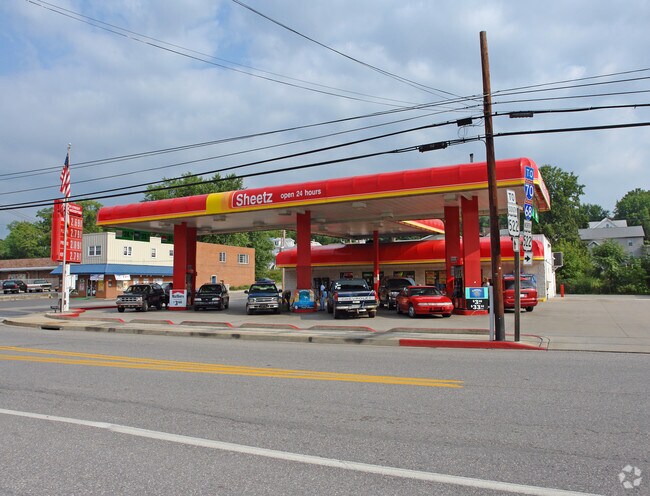
192 W Main St
05-007283
LOT 93X109 192 MAIN ST HANCOCK
Conveniencestore
Washington
U
Maryland
AE The base floodplain where base flood elevations are provided. AE Zones are now used on new format FIRMs instead of A1-A30 Zones.
192
2024
0.23 AC
2025
Washington County
010700
Washington, DC
2,056 SF
Hagerstown-Martinsburg, MD-WV
NEARBY LISTINGS FOR SALE OR LEASE
-
-
View all Hancock listings for sale on LoopNet.com
DEMOGRAPHICS near 192 W Main St
1 mile
3 mile
5 mile
2025 Total Population
1,428
3,020
6,391
2030 Population
1,466
3,080
6,492
Pop Growth 2025-2030
+ 2.66%
+ 1.99%
+ 1.58%
Average Age
43
44
44
2025 Total Households
652
1,332
2,712
HH Growth 2025-2030
+ 2.76%
+ 2.10%
+ 1.66%
Median Household Inc
$45,588
$53,170
$62,924
Avg Household Size
2.20
2.20
2.30
2025 Avg HH Vehicles
2.00
2.00
2.00
Median Home Value
$213,178
$226,726
$226,671
Median Year Built
1960
1971
1978
Nearby Places
Map Layers
Map Styles
 Street
 Aerial
Layers
 Traffic
 Biking
Places
Listings with unknown addresses are not visible on the map
- Restaurants
- Banks
- Shops
- Fitness
- Groceries
PUBLIC TRANSPORTATION
AIRPORT
Hagerstown Regional/Richard A Henson Field
Drive
Walk
Distance
Hagerstown Regional/Richard A Henson Field
41 min
32.9 mi
Nearby Properties
Address
Land Use
TOTAL SIZE
Lot Size
Zoning
Address
Land Use
TOTAL SIZE
Lot Size
Zoning
96,809 SF
44.73 AC
U
Address
Land Use
TOTAL SIZE
Lot Size
Zoning
37,441 SF
16.97 AC
U
Address
Land Use
TOTAL SIZE
Lot Size
Zoning
25,721 SF
18.23 AC
U
Address
Land Use
TOTAL SIZE
Lot Size
Zoning
28,800 SF
52.35 AC
U
Address
Land Use
TOTAL SIZE
Lot Size
Zoning
36,808 SF
31.56 AC
U
Address
Land Use
TOTAL SIZE
Lot Size
Zoning
62,260 SF
54.48 AC
HI
Address
Land Use
TOTAL SIZE
Lot Size
Zoning
89,750 SF
14.04 AC
U
Address
Land Use
TOTAL SIZE
Lot Size
Zoning
3,270 SF
18.82 AC
BG
Address
Land Use
TOTAL SIZE
Lot Size
Zoning
58,599 SF
5.25 AC
BG
Address
Land Use
TOTAL SIZE
Lot Size
Zoning
21,488 SF
0.32 AC
U
Address
Land Use
TOTAL SIZE
Lot Size
Zoning
26,600 SF
1.55 AC
U
Address
Land Use
TOTAL SIZE
Lot Size
Zoning
8,134 SF
18 AC
Address
Land Use
TOTAL SIZE
Lot Size
Zoning
26,214 SF
1.89 AC
U
Address
Land Use
TOTAL SIZE
Lot Size
Zoning
6,060 SF
8.96 AC
U
Address
Land Use
TOTAL SIZE
Lot Size
Zoning
22,590 SF
1.12 AC
U
Address
Land Use
TOTAL SIZE
Lot Size
Zoning
800 SF
146.66 AC
EC
Address
Land Use
TOTAL SIZE
Lot Size
Zoning
18,000 SF
6.41 AC
U
Address
Land Use
TOTAL SIZE
Lot Size
Zoning
113.07 AC
Address
Land Use
TOTAL SIZE
Lot Size
Zoning
8,640 SF
0.32 AC
U
Address
Land Use
TOTAL SIZE
Lot Size
Zoning
2,088 SF
3.50 AC
U
Address
Land Use
TOTAL SIZE
Lot Size
Zoning
7,360 SF
7.35 AC
U
Address
Land Use
TOTAL SIZE
Lot Size
Zoning
15,092 SF
2.02 AC
U
Address
Land Use
TOTAL SIZE
Lot Size
Zoning
5,296 SF
0.22 AC
U
Address
Land Use
TOTAL SIZE
Lot Size
Zoning
2,232 SF
0.41 AC
U
Address
Land Use
TOTAL SIZE
Lot Size
Zoning
2,700 SF
2.80 AC
U
Address
Land Use
TOTAL SIZE
Lot Size
Zoning
12,957 SF
0.50 AC
U
Address
Land Use
TOTAL SIZE
Lot Size
Zoning
2,292 SF
1.69 AC
U
Address
Land Use
TOTAL SIZE
Lot Size
Zoning
183.85 AC
U
Address
Land Use
TOTAL SIZE
Lot Size
Zoning
4,200 SF
0.92 AC
U
Address
Land Use
TOTAL SIZE
Lot Size
Zoning
48,190 SF
5 AC
U
The World's #1 Commercial Real Estate Marketplace
Connect with us
© 2026 CoStar Group
The information above has been obtained from sources believed reliable. While we do not doubt its accuracy we have not verified it and make no guarantee, warranty or representation about it. It is your responsibility to independently confirm its accuracy and completeness. Any projections, opinions, assumptions, or estimates used are for example only and do not represent the current or future performance of the property. The value of this transaction to you depends on tax and other factors which should be evaluated by your tax, financial, and legal advisors. You and your advisors should conduct a careful, independent investigation of the property to determine to your satisfaction the suitability of the property for your needs.