Property Record
192 Windsorville Rd, Ellington, CT 06029
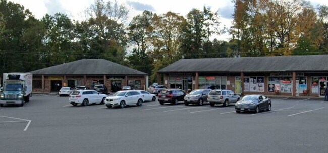

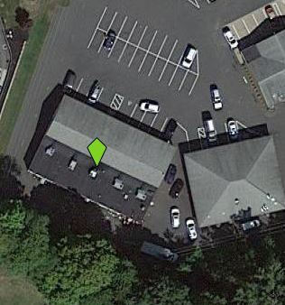
Property Detail
192 Windsorville Rd
ELLI-000009-000066
Capitol
Commercialnec
Connecticut
C
2.40 AC
2025
Tolland County
2025
Hartford
510200
Hartford-West Hartford-East Hartford, CT
NEARBY LISTINGS FOR SALE OR LEASE
DEMOGRAPHICS near 192 Windsorville Rd
1 mile
3 mile
5 mile
2025 Total Population
6,956
42,855
80,567
2030 Population
7,086
43,821
82,313
Pop Growth 2025-2030
+ 1.87%
+ 2.25%
+ 2.17%
Average Age
42
41
42
2025 Total Households
3,307
18,723
34,225
HH Growth 2025-2030
+ 2.00%
+ 2.37%
+ 2.25%
Median Household Inc
$93,335
$93,613
$100,589
Avg Household Size
2.10
2.20
2.30
2025 Avg HH Vehicles
2.00
2.00
2.00
Median Home Value
$268,761
$312,627
$326,425
Median Year Built
1978
1973
1975
Nearby Places
Map Layers
Map Styles
 Street
 Aerial
Layers
 Traffic
 Biking
Places
Listings with unknown addresses are not visible on the map
- Restaurants
- Banks
- Shops
- Fitness
- Groceries
PUBLIC TRANSPORTATION
AIRPORT
Bradley International
Drive
Walk
Distance
Bradley International
39 min
19.3 mi
Freight Ports
Port of New Haven
Drive
Walk
Distance
Port of New Haven
67 min
51.6 mi
SALE & LEASE HISTORY
LISTING DATE
SALE/LEASE

Jun 22, 2022
For Lease
Aug 21, 2023
For Lease
Nearby Properties
Address
Land Use
TOTAL SIZE
Lot Size
Zoning
Address
Land Use
TOTAL SIZE
Lot Size
Zoning
75.65 AC
PDZ GE
Address
Land Use
TOTAL SIZE
Lot Size
Zoning
3,200 SF
31.39 AC
INDUST
Address
Land Use
TOTAL SIZE
Lot Size
Zoning
29.87 AC
PDZ GE
Address
Land Use
TOTAL SIZE
Lot Size
Zoning
63.72 AC
R-22
Address
Land Use
TOTAL SIZE
Lot Size
Zoning
52.04 AC
MF
Address
Land Use
TOTAL SIZE
Lot Size
Zoning
71.60 AC
MF
Address
Land Use
TOTAL SIZE
Lot Size
Zoning
40 AC
MF
Address
Land Use
TOTAL SIZE
Lot Size
Zoning
24.02 AC
COMMER
Address
Land Use
TOTAL SIZE
Lot Size
Zoning
Address
Land Use
TOTAL SIZE
Lot Size
Zoning
188,775 SF
74.13 AC
R-27
Address
Land Use
TOTAL SIZE
Lot Size
Zoning
33.41 AC
MF
Address
Land Use
TOTAL SIZE
Lot Size
Zoning
7.95 AC
DBR
Address
Land Use
TOTAL SIZE
Lot Size
Zoning
29.97 AC
PC
Address
Land Use
TOTAL SIZE
Lot Size
Zoning
85,470 SF
14.11 AC
R
Address
Land Use
TOTAL SIZE
Lot Size
Zoning
11 AC
R-27
Address
Land Use
TOTAL SIZE
Lot Size
Zoning
27.05 AC
COMMER
Address
Land Use
TOTAL SIZE
Lot Size
Zoning
54.80 AC
PRD
Address
Land Use
TOTAL SIZE
Lot Size
Zoning
24.66 AC
C
Address
Land Use
TOTAL SIZE
Lot Size
Zoning
15.89 AC
PRD
Address
Land Use
TOTAL SIZE
Lot Size
Zoning
16.18 AC
COMMER
Address
Land Use
TOTAL SIZE
Lot Size
Zoning
3,200 SF
9.09 AC
COMMER
Address
Land Use
TOTAL SIZE
Lot Size
Zoning
85.13 AC
RW
Address
Land Use
TOTAL SIZE
Lot Size
Zoning
80,487 SF
11.41 AC
DMF
Address
Land Use
TOTAL SIZE
Lot Size
Zoning
31.50 AC
PRD
Address
Land Use
TOTAL SIZE
Lot Size
Zoning
18.49 AC
PRD
Address
Land Use
TOTAL SIZE
Lot Size
Zoning
15.84 AC
R
Address
Land Use
TOTAL SIZE
Lot Size
Zoning
45,666 SF
15.33 AC
RR
Address
Land Use
TOTAL SIZE
Lot Size
Zoning
13.44 AC
RC
Address
Land Use
TOTAL SIZE
Lot Size
Zoning
17.55 AC
COMMER
Address
Land Use
TOTAL SIZE
Lot Size
Zoning
19.38 AC
C
The World's #1 Commercial Real Estate Marketplace
Connect with us
© 2026 CoStar Group
The information above has been obtained from sources believed reliable. While we do not doubt its accuracy we have not verified it and make no guarantee, warranty or representation about it. It is your responsibility to independently confirm its accuracy and completeness. Any projections, opinions, assumptions, or estimates used are for example only and do not represent the current or future performance of the property. The value of this transaction to you depends on tax and other factors which should be evaluated by your tax, financial, and legal advisors. You and your advisors should conduct a careful, independent investigation of the property to determine to your satisfaction the suitability of the property for your needs.